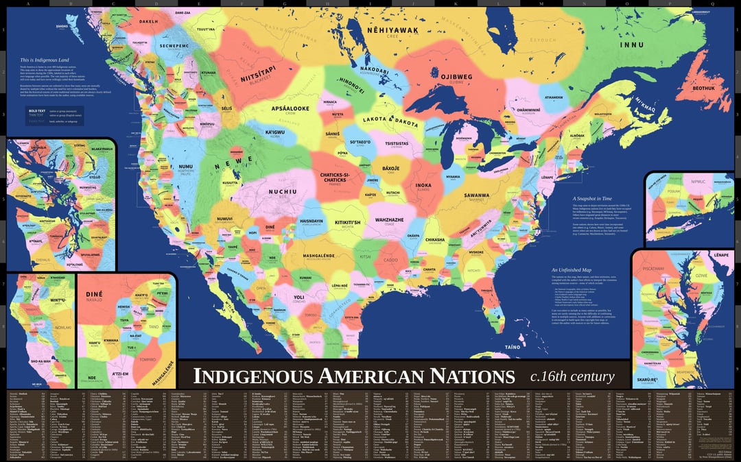
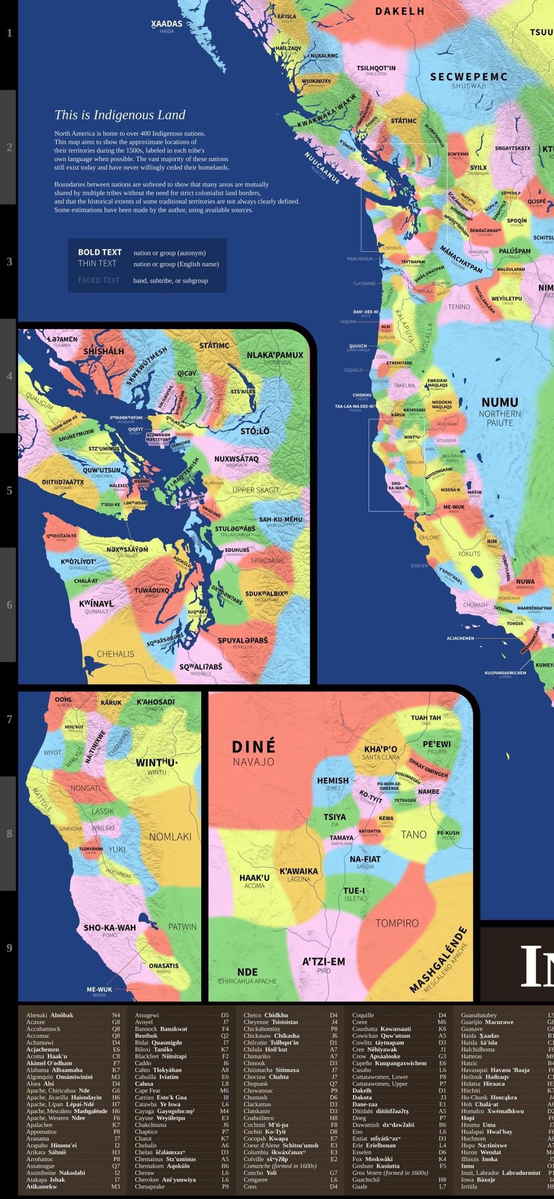
What I find most fascinating about this is how closely some of the tribal territorial divisions are at the US/Mexico border when compared to the modern border.
whilst the map does note that the edges are fuzzy, they are still sharp enough to give off the impression of understood borders, and in some cases it just misses the mark entirely, such as the land of the Miami (myaamia) not including their capitol (kiihkayonki, modern day fort Wayne Indiana).
I wonder if the places that have many names close together have the better resources?
Norwester77 on
Some of these categories (like Kalapuya, Pomo, Miwok, and Yokuts) are actually small language families, not individual tribes/nations/ethnicities.
JohnnieTango on
I get the point of this map and all and appreciate it. However, something to remember is that the idea of a “nation” is a European Enlightenment/19th century concept that has been gradually adopted out by the non-Western world.
Not to be too pedantic, but this is really better thought of as a tribal map.
Key-Medicine733 on
Wut happened?
Beneficial_Foot_436 on
Where is Cherokee? map seems off.
edit: ah found them….map still has their range off according to family
bikes_rock_books on
It really should say “North” American
MagicalTrev0r on
Crazy how this 1500s is so different and more fractured than 1000s America. Truly a collapse of so many great societies, shout out [The Mississippian.](https://en.wikipedia.org/wiki/Mississippian_culture)
They built structures in Souther Illinois the size of the Great Pyramids. Largely forgotten.
bluesmaker on
I would love to see this kind of thing alongside a set of high quality illustrations that show some aspects of life in various tribes. Like our view of native Americans historically is generally pretty flat. So illustrations are an interesting way to convey some of the differences in clothing, culture, way of life and so on.
JudasWasJesus on
What years? Im oneida this is very skewed?
Xanosaur on
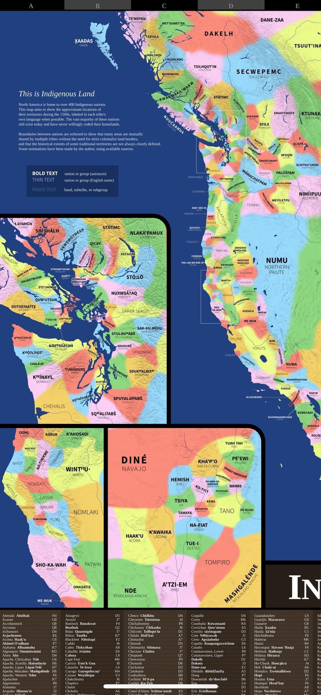
In Vancouver, you have Tsleil-Waututh and Musqueam literally covering Squamish reserves. the map is not very accurate
Graceful_Trekker on
These maps are very wrong.
brigitanti on
Whoa, fuzzy borders make total sense for those fluid tribal histories. Mind blown.
nwbrown on
They are close to real boundaries because they follow natural boundaries and a lot of them are made up.
benjancewicz on
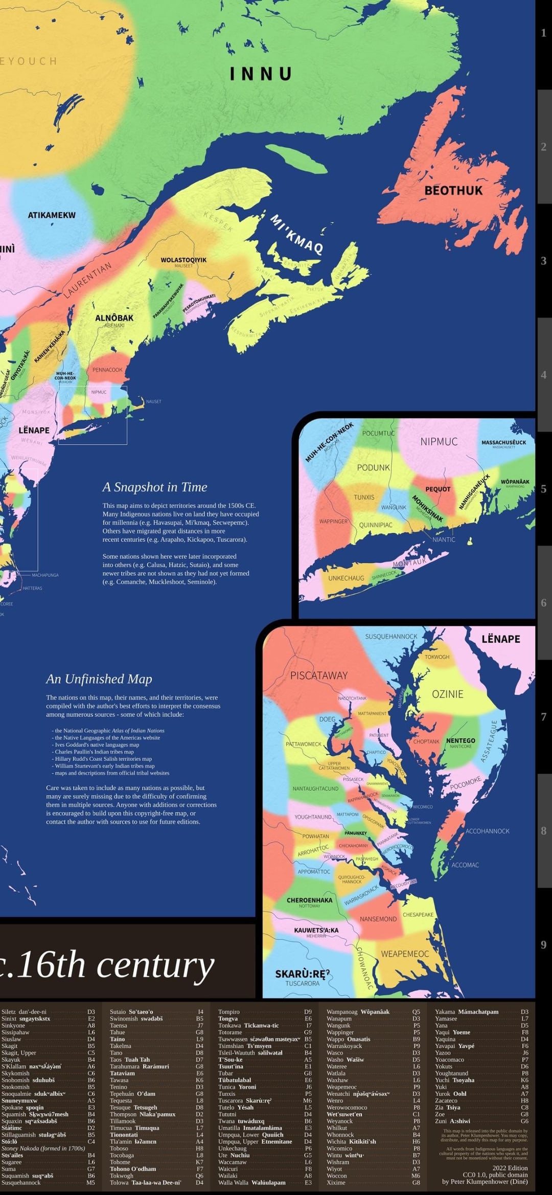
Once again, Naskapi people have been excluded.
GreaterGoodIreland on
> Post says tribes
> Map says nations
Pick one mate 😀
nochinzilch on
It feels disingenuous to just say that some tribes “migrated great distances” when they were death marched off their land.
megalynn44 on
Chattanooga is ALWAYS a boarder town. No matter what map it is.
A_Texas_Hobo on
Comanche? This map is trash.
How do you leave out one of the most dominant and feared tribes in history?
Paratwa on
Neat it actually had my people show up correctly, most maps miss the Ais and Adai.
Commercial-Ad7119 on
Indigenous NORTH AMERICAN Nations!
JacquesBlaireau13 on
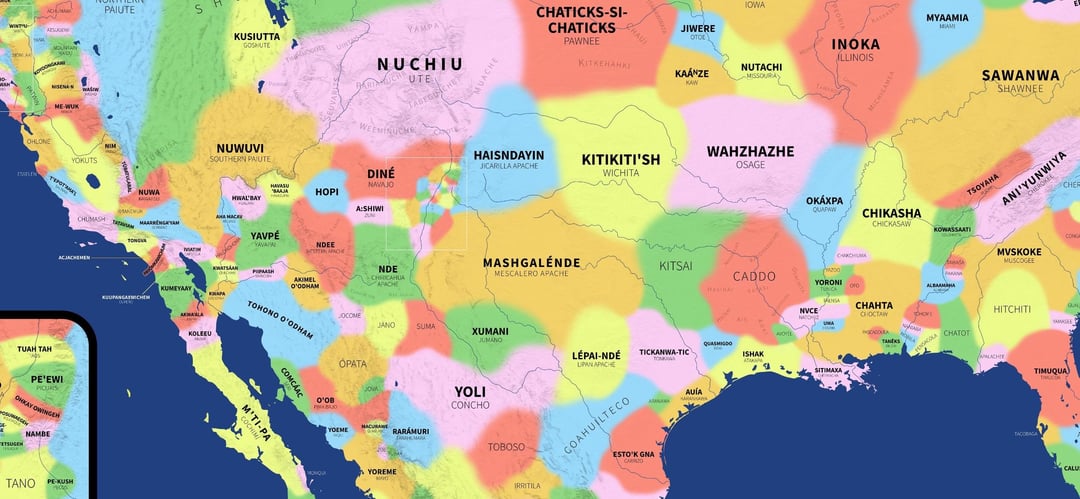
I don’t see the Zuni lands delineated. These were the first people encountered by Coronado in New Mexico propper.
116wins on
Living in Western Washington, it’s interesting to see how virtually all of the tribes listed here have given their name to local towns/counties/landmarks/etc
UrWifesOtherBF on
Shawnee were badasses. Controlled the rich and fertile Ohio River Valley, but never built large villages or towns. Allan Eckert’s the Frontiersman and That Dark and Bloody river are absolutely amazing historical narratives.
dyl73 on
Would my anthropologist gf like a poster of this? How accurate is it?


28 Comments
Make this higher resolution plz
Source?
whilst the map does note that the edges are fuzzy, they are still sharp enough to give off the impression of understood borders, and in some cases it just misses the mark entirely, such as the land of the Miami (myaamia) not including their capitol (kiihkayonki, modern day fort Wayne Indiana).
it’s not *bad*, however
a slightly better map: https://native-land.ca/
Alll gone
I wonder if the places that have many names close together have the better resources?
Some of these categories (like Kalapuya, Pomo, Miwok, and Yokuts) are actually small language families, not individual tribes/nations/ethnicities.
I get the point of this map and all and appreciate it. However, something to remember is that the idea of a “nation” is a European Enlightenment/19th century concept that has been gradually adopted out by the non-Western world.
Not to be too pedantic, but this is really better thought of as a tribal map.
Wut happened?
Where is Cherokee? map seems off.
edit: ah found them….map still has their range off according to family
It really should say “North” American
Crazy how this 1500s is so different and more fractured than 1000s America. Truly a collapse of so many great societies, shout out [The Mississippian.](https://en.wikipedia.org/wiki/Mississippian_culture)
They built structures in Souther Illinois the size of the Great Pyramids. Largely forgotten.
I would love to see this kind of thing alongside a set of high quality illustrations that show some aspects of life in various tribes. Like our view of native Americans historically is generally pretty flat. So illustrations are an interesting way to convey some of the differences in clothing, culture, way of life and so on.
What years? Im oneida this is very skewed?
In Vancouver, you have Tsleil-Waututh and Musqueam literally covering Squamish reserves. the map is not very accurate
These maps are very wrong.
Whoa, fuzzy borders make total sense for those fluid tribal histories. Mind blown.
They are close to real boundaries because they follow natural boundaries and a lot of them are made up.
Once again, Naskapi people have been excluded.
> Post says tribes
> Map says nations
Pick one mate 😀
It feels disingenuous to just say that some tribes “migrated great distances” when they were death marched off their land.
Chattanooga is ALWAYS a boarder town. No matter what map it is.
Comanche? This map is trash.
How do you leave out one of the most dominant and feared tribes in history?
Neat it actually had my people show up correctly, most maps miss the Ais and Adai.
Indigenous NORTH AMERICAN Nations!
I don’t see the Zuni lands delineated. These were the first people encountered by Coronado in New Mexico propper.
Living in Western Washington, it’s interesting to see how virtually all of the tribes listed here have given their name to local towns/counties/landmarks/etc
Shawnee were badasses. Controlled the rich and fertile Ohio River Valley, but never built large villages or towns. Allan Eckert’s the Frontiersman and That Dark and Bloody river are absolutely amazing historical narratives.
Would my anthropologist gf like a poster of this? How accurate is it?