I used to collect these maps back when you could get a little paper pamphlet free from every city you visited.
I would have loved to have that one!
CapKashikoi on
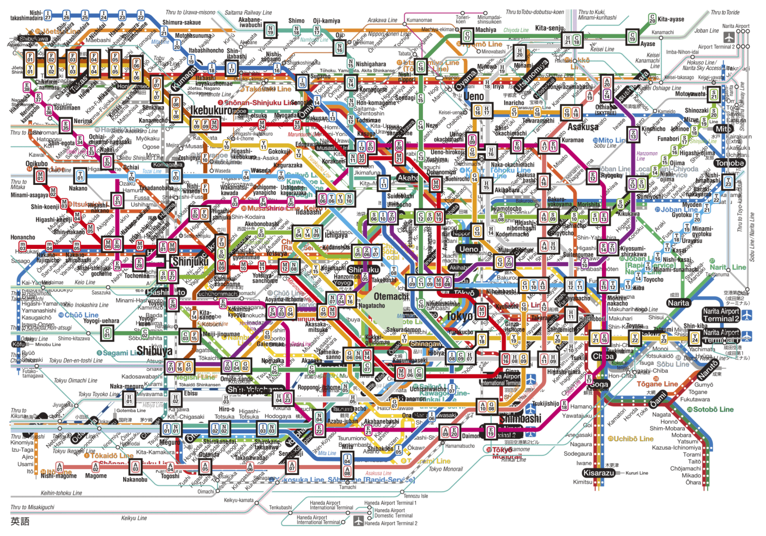
Shinjuku Station in the center has 12 lines passing through it with over 3 million passengers using the station daily. There are 200 exits. Its the busiest station in the world and a madhouse during rush hour.
LinkSeekeroftheNora on
That’s so impressively dense. Kudos to the people who live there, because I know I’d make tons of mistakes trying to navigate this.
BrightCar on
this map looks like someone zoomed in too far on a bowl of spaghetti and just rolled with it
CAMOME_SENSEI on
Eastside of this map includes outside of Tokyo.
While it needs more paper in westside. It is almost a half.
superitem on
It looks like you put two maps together, one showing the subway network and another showing the entire greater Tokyo area.
Freak_Out_Bazaar on
This is two maps that are distorted both in distance and direction stacked on top of each other. It gets less and less accurate as you go further out, like Futako-Tamagawa Station is next to Kofu Station but in reality they are more than 2 hours apart.
Here’s an official map by JR East that’s much more comprehensive


7 Comments
I used to collect these maps back when you could get a little paper pamphlet free from every city you visited.
I would have loved to have that one!
Shinjuku Station in the center has 12 lines passing through it with over 3 million passengers using the station daily. There are 200 exits. Its the busiest station in the world and a madhouse during rush hour.
That’s so impressively dense. Kudos to the people who live there, because I know I’d make tons of mistakes trying to navigate this.
this map looks like someone zoomed in too far on a bowl of spaghetti and just rolled with it
Eastside of this map includes outside of Tokyo.
While it needs more paper in westside. It is almost a half.
It looks like you put two maps together, one showing the subway network and another showing the entire greater Tokyo area.
This is two maps that are distorted both in distance and direction stacked on top of each other. It gets less and less accurate as you go further out, like Futako-Tamagawa Station is next to Kofu Station but in reality they are more than 2 hours apart.
Here’s an official map by JR East that’s much more comprehensive
https://www.jreast.co.jp/e/routemaps/pdf/routemap_majorrailsub.pdf