

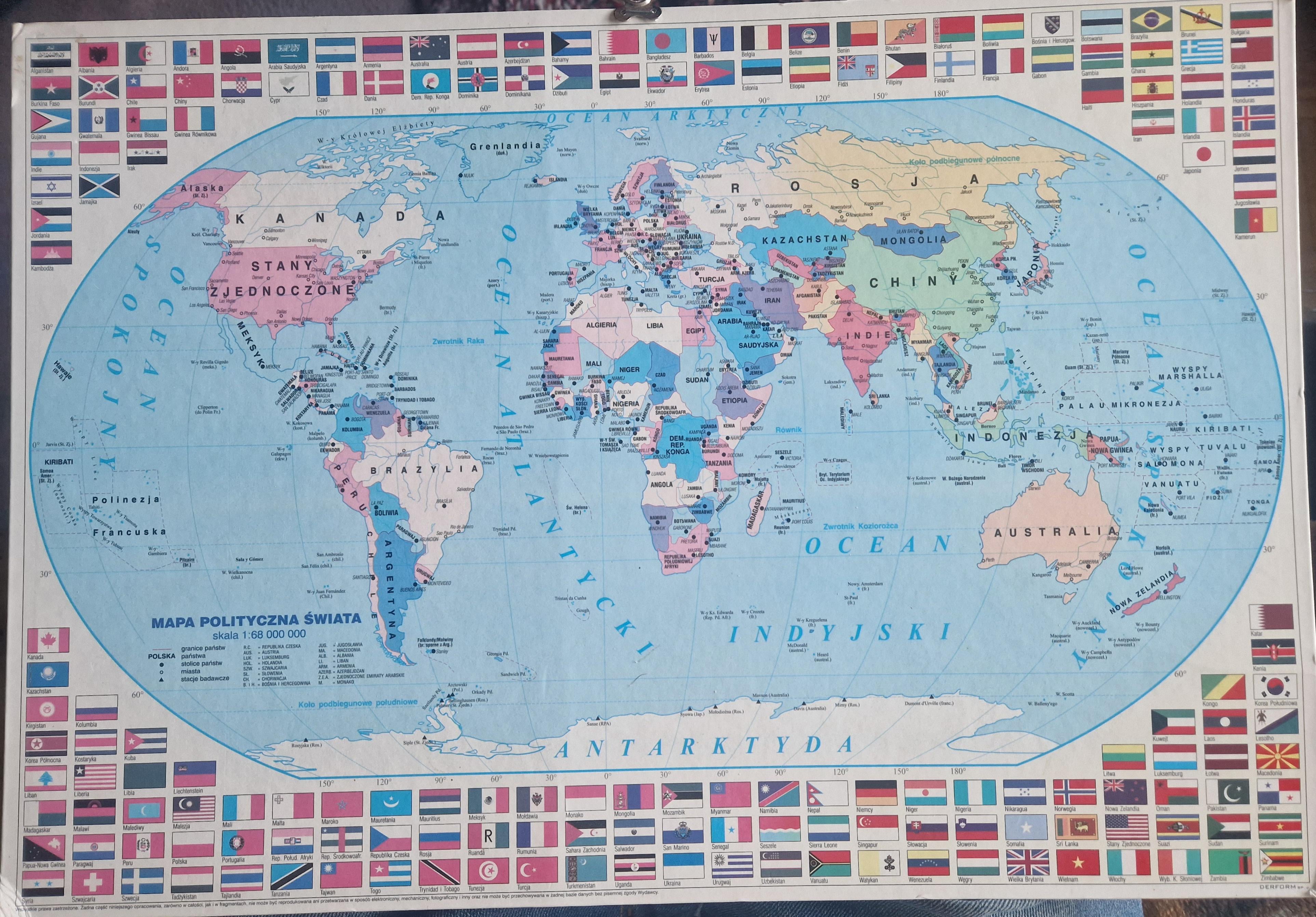
Hi. I came to visit my grandparents for Christmas, and there has always been a world map with flags hanging on the wall here. I have seen many attempts to date various maps and decided to try it myself.
I had no idea what period this map might be from, so I started with the more obvious things.
The first thing that caught my eye was the presence of Yugoslavia (Serbia and Montenegro).
So the map is from before February 4, 2003.
East Timor is marked on the map, which means it's after May 20, 2002.
But wait…
I started looking at the flags, and the first one that caught my eye was the flag of Afghanistan, which was used from April 27, 1992, to December 6, 1992…
So yes… I think this map is at least a little bit incorrect.
As for the flags, I also noticed that there is a non-communist flag of Tajikistan, which was created on November 24, 1992.
The breakup of Czechoslovakia took place in 1993, which is another contradiction.
I don't know what to make of this fact.
Other inaccuracies I noticed include Astana in Kazakhstan being marked in the place of Almaty and the flag of Haiti without the emblem that was used in 1820-1849.
So, ultimately, it seems to me that the map itself is from the period between May 20, 2002, and February 4, 2003, and the flags are from the period between November 24, 1992, and December 6, 1992.
It turned out a bit strange. Maybe someone would like to clarify one or the other. But it is also strange that there is such a discrepancy between the flags and the map.
Posted by TheKrzakkTTV
28 Comments
I had this map when I was around 15 in the early 2000s but in English. I clearly remember the flags around the map
I remember this map from a school atlas I had in the 90s. Perhaps they recycled the old map in new edition, but not everything was updated.
Haha awesome I used to have this map on my desk as a kid
Pick somewhere nice for dinner, work out things that the two of you have in common, wear something decent and you’re good to go.
Best way to rizz up a map:
*Hey baby, I like dem curves!*
Or
*Do you like funny men? Cuz I’m a hill-areas guy!*
These are quite powerful, so use them with caution.
Judging from the Afghan flag, 1992.
Bosnian flag is pre-1998 (1992-1998 to be exact), Mongolian flag is post-1992 (no star in the top left), Macedonian flag is post-1995 (but if there’s any Macedonians in this thread – feel free to correct me), Georgian flag is pre-2003, so around 1996-1997?
Gonna be honest, I think it’s got some ‘personality’ issues going on. I think you can do better. Have some confidence, and get back in to the pool!
The things I first looked for.
South Africa still has the Apartheid era flag (changed in 1994).
Estonia is independent (free in 1991).
Bosnia Herzegovina is independent from Serbia (1992).
Czechioslovakia is separate (1993).
Afganistan’s flag is the one used from 27 April 1992 to 6 December 1992.
So.. I’ll go with 1993 – when the map was actually printed. Maybe. But as you said – there’s stuff that doesn’t make a lot of sense.
End of ‘90
According to the flags, it’s 1992-1994
That flag of Afghanistan was only around in 1992.
[https://en.wikipedia.org/wiki/List_of_Afghan_flags#Historical_flags](https://en.wikipedia.org/wiki/List_of_Afghan_flags#Historical_flags)
well normally i only date women but i guess i can be open minded.
Look at which countries are present and which aren’t, you can date it based on that
what language is that?
It has to be 2002 – just before Yugoslavia transitioned into Serbia and Montenegero, right after East Timor became independent and Rwanda acquired a new flag. The flag of Afghanistan is indeed incorrect but I guess this one is just a mistake.
taiwan shown as part of china, i guess the map is from the future?
I would hold out and try to date an Atlas instead. More variety, for one thing.
All I can add is that it is sometime after February 16, 1965, as the it has the it has Canada’s (or Kanada on the map…) current red Maple Leaf flag.
1990-94
[deleted]
I think Timor Leste is what’s throwing you off. It became independent in 1975 and was annexed by Indonesia a year later. But annexed countries are sometimes still displayed as independent on maps, depending on who makes it (e.g. Crimea is annexed by Russia since 2014 but still shown as part of Ukraine on most maps). With the UN, Timor Leste remained a “non-self-governing territory under Portuguese administration” during the Indonesian occupation. In 1999 it came under UN administration, and it became fully independent in 2002.
The South African flag is from pre-1994 both Czechia and Slovakia flags are there unlike on the map ( I assume the mistake is on the map not flags ) so anywhere between 1 January 1993 and 26 April 1994 ( assuming there’s no other major contradiction )
Clues the map/flags give:
-DRC flag is the Republic of Zaire flag but it being labeled as the DRC (switch happened in 1997 according to the Wikipedia history of their flag)
-Bosnia and Herzegovina flag is the one used from 1992-1998
-Rwanda flag is the one used from 1961-2001
-Dodoma is the capital of Tanzania (officially recognized as such beginning in 1996 according to its Wikipedia page)
-Ethiopia flag doesn’t have the star in it, so it’s probably during the transition period between their communist and current governments (1991-1996 according to their flag history on Wikipedia)
-You mentioned the incorrect marking of Kazakhstan’s capital, and the switch between Almaty and Astana took place in 1997
-You also mention the presence of Timor-Leste, which became recognized as independent in 2002 and
So my guess is it’s probably from somewhere between 1995ish to 2003ish or so, and the makers just didn’t change some of the flags for some reason. The words appear to be in what I’m guessing is Polish, so maybe the Poles just didn’t feel like recognizing certain changes or something?
I had that exact map in my room, it was on a thick carton, shiny. It was in Poland, late 90s.
Astana also means capital in Kazakh. Almaty was the capital of KZ for a brief period from 1991 to 1997, if that helps. So they probably figured out the Astana part, and marked it in the wrong place. It’s just half-assed atlas with a lot of mistakes and inconsistencies. For this particular mistake to happen it has to be post 1997.
OK, this is something between 1995 and 1997, since Belarus already has the flag of Lukashenko, and Rwanda still has the letter R, and Bosnia still has a white flag, and Congo still has the flag of Zaire.
So this is most likely a transitional version of 1994-1995. Since South Africa still has the old flag, but Belarus already has a new one.
UPDATE:
I learned a few interesting things.
The flag of Afghanistan was changed in 1992, but many countries did not recognize the change and continued to use the old flag. East Timor is marked on the map, but Poland did not recognize its earlier annexation in 1976 and even pushed for its independence, so this is not a clue. In addition, the name Zaire is not on the map, only DRC. This change took place in May 1997. In India, Mumbai is written as Bombay, and the old name was used until 1995, but many atlases continued to show the old name for a long time. So I conclude that the map dates from 1997-98. The only inaccuracy at this point is the changed flag of South Africa, but this should be ignored.