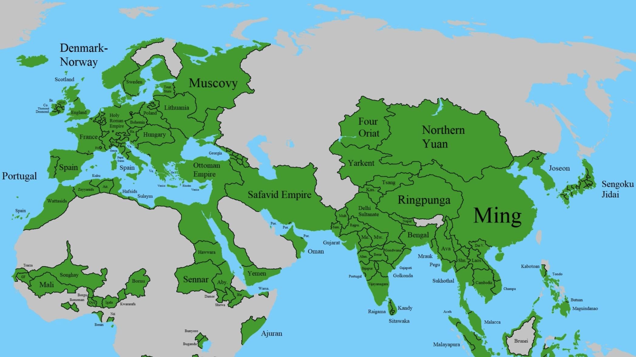
Nice effort. Why did you leave out empty patches in central Asia?
Realistic-Swing1533 on
Sukkhothai has been annexed by Ayutthaya since the 1400s,Laos and Cambodia was also the modern nation state name not the name of the historical civilization, but overall an interesting map!
Mountain_Dentist5074 on
You mean Ming and his vassals??
jhoiboich on
Sengoku Jidai is the name for a period in Japan’s history, not the name of the state at that time
ConstructionOwn2909 on
I think the Indochina Penisula was a bit different back then? The countries known as “Cambodia” or “Laos” didn’t exist, yet. Or at least, the names didn’t…
Though, yeah, you got modern Viet Nam right: sub-divided into Dai Viet and Champa back then. Just don’t ask what happens to Champa
renke0 on
This is awesome! Do you have it in a higher res? Reddit compression blurs a lot of the smaller details
Duanedoberman on
Manchuria, north of China and the Korean peninsula was pretty well known and would soon invade China to overthrow the Ming Dynasty and form the Qing Dynasty
Das_Lloss on
Why did they name a duck after 1500s Russia?
kebusebu on
Sengoku Jidai isn’t a name of a state, but rather the historical time period for Japan at that time. I think more accurate term to use would be “Warring States-Japan”, though I’m sure there are better ways to call Japan at that time.
GustavoistSoldier on
You forgot about multiple polities.
Mahakurotsuchi on
That’s bs for CA. Khanates had clear borders and have been part of silk road for centuries. It’s two centuries too early for oirat (zhonghar) invasion, so you are off by 1000 km to west. That territory is quite literally birth place of Kazakh khanate. Kazakh, Nogai, Uzbek khanates are entirely missing. Despite having hundreds of thousands in population and having territory close to a most of Europe.
I admire the effort, but erosure of clear and written history like this gives breath to the fascist narratives in places like Russia where they claim that nobody around them even had state before they came along. Despite you know, Turkish Khaganate being 5 centuries older than even Kievan Russ, not even talking about Moscovy
ntfcastro on
It’s kind of crazy to see Portugal already established in India, Arabian Peninsula etc. And even then, this map is probably still missing a few smaller forts, trading posts, and islands that were already under Portuguese control. By that point, the Empire stretched from the Atlantic to the Indian Ocean, including places like Goa, Cochin, Diu, Malacca, Hormuz, Cape Verde, São Tomé, and early footholds along the coasts of Angola and Mozambique.
TheRedhood49 on
Sitawaka and Raigama aren’t established as kingdoms until 1521 after the spoiling if vijayabahu, Kandy is peripheral kingdom until 1594. As of 1517 it’s kingdom of Kotte (and Kandyan provinces) and Kingdom of Jaffna.
yanki2del on
Wasn’t Afghanistan part of Safavids at this time?
deepindra on
kumaon and garhwal kingdom are in nepal?
UsedDevelopment4741 on
Yo Lithuania apparently was lit, it wasn’t clear to me that they had such a huge kingdom
engr_20_5_11 on
Oyo is further south than your map laying southwest of Igala (Idah) and west of Edo (Benin). That also places the Igala further west than shown. The Nupe and Gwari (Hausa banza states) were directly west of the Igala. Oyo was bordered to the north by Borgu and Nupe, the east by Edo, South West by the Egu (their sometimes vassals) and north east by Idah
Borgu was much smaller than shown.
None of the 14 Hausa states in your map (Hausa Bakwai and Bakwai Banza)
Nri was much smaller than depicted and further west than shown. A lot of that area shown as Nri were communities loosely affliated with Nri, the twin kingdoms of Ibom and Akwa Akpa, and the remnants of the Ekoi.
None of the Akani in your map
zzoopee on
Hungarian perfection
ChildOfDeath07 on
Brunei’s depiction in this map is highly questionable
While Bruneian historiography claims they held control over the entire island of Borneo, their exact relationship with the other sultanates of Borneo and Sulu is still a subject of debate, though we can confirm they at minimum controlled what is now Sabah and Sarawak
Its also difficult to say if Melaka truly continued to hold control over most of their empire after the city’s fall, especially their northern territories and Pahang, which could be said to have become more like an ally than a subject at the point. We at least know the south continued to remain in their sphere though, as they continued to pay tribute to the rump state in Bintan, and later developed into the Sultanate of Johor

")
20 Comments
Nice effort. Why did you leave out empty patches in central Asia?
Sukkhothai has been annexed by Ayutthaya since the 1400s,Laos and Cambodia was also the modern nation state name not the name of the historical civilization, but overall an interesting map!
You mean Ming and his vassals??
Sengoku Jidai is the name for a period in Japan’s history, not the name of the state at that time
I think the Indochina Penisula was a bit different back then? The countries known as “Cambodia” or “Laos” didn’t exist, yet. Or at least, the names didn’t…
Though, yeah, you got modern Viet Nam right: sub-divided into Dai Viet and Champa back then. Just don’t ask what happens to Champa
This is awesome! Do you have it in a higher res? Reddit compression blurs a lot of the smaller details
Manchuria, north of China and the Korean peninsula was pretty well known and would soon invade China to overthrow the Ming Dynasty and form the Qing Dynasty
Why did they name a duck after 1500s Russia?
Sengoku Jidai isn’t a name of a state, but rather the historical time period for Japan at that time. I think more accurate term to use would be “Warring States-Japan”, though I’m sure there are better ways to call Japan at that time.
You forgot about multiple polities.
That’s bs for CA. Khanates had clear borders and have been part of silk road for centuries. It’s two centuries too early for oirat (zhonghar) invasion, so you are off by 1000 km to west. That territory is quite literally birth place of Kazakh khanate. Kazakh, Nogai, Uzbek khanates are entirely missing. Despite having hundreds of thousands in population and having territory close to a most of Europe.
I admire the effort, but erosure of clear and written history like this gives breath to the fascist narratives in places like Russia where they claim that nobody around them even had state before they came along. Despite you know, Turkish Khaganate being 5 centuries older than even Kievan Russ, not even talking about Moscovy
It’s kind of crazy to see Portugal already established in India, Arabian Peninsula etc. And even then, this map is probably still missing a few smaller forts, trading posts, and islands that were already under Portuguese control. By that point, the Empire stretched from the Atlantic to the Indian Ocean, including places like Goa, Cochin, Diu, Malacca, Hormuz, Cape Verde, São Tomé, and early footholds along the coasts of Angola and Mozambique.
Sitawaka and Raigama aren’t established as kingdoms until 1521 after the spoiling if vijayabahu, Kandy is peripheral kingdom until 1594. As of 1517 it’s kingdom of Kotte (and Kandyan provinces) and Kingdom of Jaffna.
Wasn’t Afghanistan part of Safavids at this time?
kumaon and garhwal kingdom are in nepal?
Yo Lithuania apparently was lit, it wasn’t clear to me that they had such a huge kingdom
Oyo is further south than your map laying southwest of Igala (Idah) and west of Edo (Benin). That also places the Igala further west than shown. The Nupe and Gwari (Hausa banza states) were directly west of the Igala. Oyo was bordered to the north by Borgu and Nupe, the east by Edo, South West by the Egu (their sometimes vassals) and north east by Idah
Borgu was much smaller than shown.
None of the 14 Hausa states in your map (Hausa Bakwai and Bakwai Banza)
Nri was much smaller than depicted and further west than shown. A lot of that area shown as Nri were communities loosely affliated with Nri, the twin kingdoms of Ibom and Akwa Akpa, and the remnants of the Ekoi.
None of the Akani in your map
Hungarian perfection
Brunei’s depiction in this map is highly questionable
While Bruneian historiography claims they held control over the entire island of Borneo, their exact relationship with the other sultanates of Borneo and Sulu is still a subject of debate, though we can confirm they at minimum controlled what is now Sabah and Sarawak
Its also difficult to say if Melaka truly continued to hold control over most of their empire after the city’s fall, especially their northern territories and Pahang, which could be said to have become more like an ally than a subject at the point. We at least know the south continued to remain in their sphere though, as they continued to pay tribute to the rump state in Bintan, and later developed into the Sultanate of Johor
Full of wrongs