Super interesting! Question…I know York factory but those towns on the eastern side of Hudson’s bay/ St James bay…. Were those actual villages with English residents? Because afaik it’s all Cree/ Inuit there currently
bearlybearbear on
That’s a great map.
Chazut on
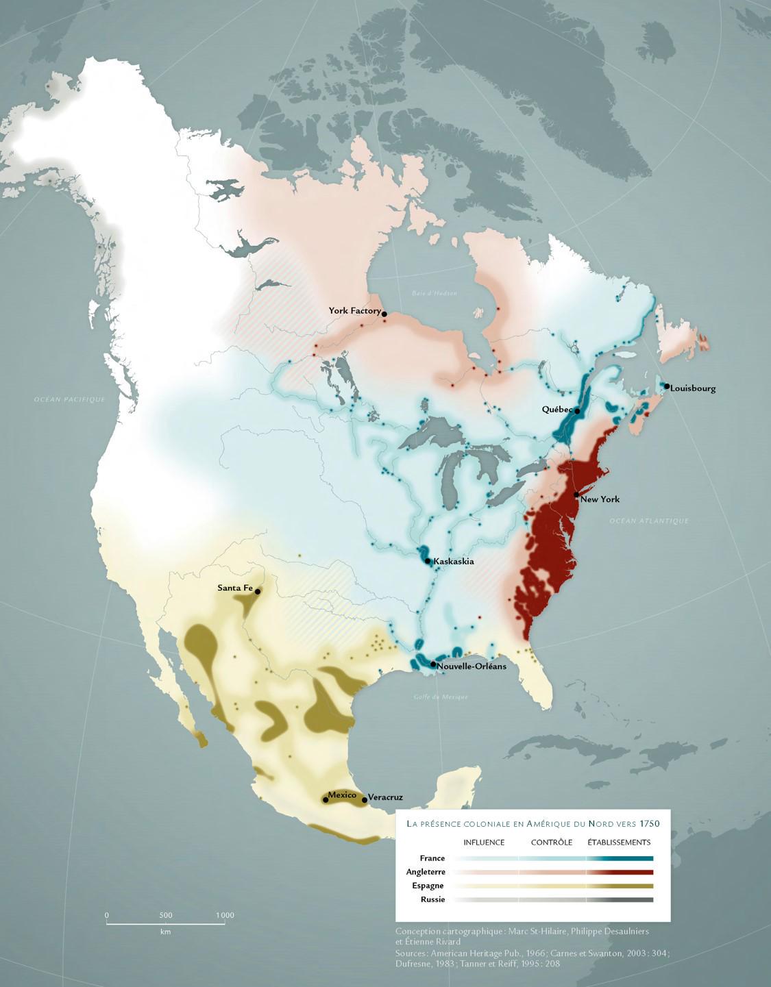
terrible map, why is Mexico shown like that?
previousinnovation on
Very cool, although I think a different color for the Russians would be preferable.
Hefty_Anywhere_8537 on
That’s actually great, it’s not realistic when you see maps of gigantic areas of control when it really wohld have only been a few spots.
Themasterofgoats on
Mexico is quite incorrect on this map- by the 1750 Spanish control over Mexico proper had integrated indigenous peoples into the empire in a centralized system, not counting that here is excluding most of the population really
CigsAndAlcohol13 on
English win again

myfault on
This map is not just “approximate”, it is conceptually misleading.
It mixes three very different things under the same visual language: settlement, military presence, and influence, and by doing so it ends up telling a distorted story of colonial control in North America circa 1750.
The problem is the choice of markers. By privileging forts, trading posts, and coastal enclaves, the map implicitly adopts an Anglo-French frontier logic and then applies it wholesale to Spain, where it simply does not work.
Spanish America was not organized around thin military dots projecting influence into empty space. It was organized around cities, towns, parishes, roads, land grants, and indigenous communities fully integrated into imperial administration. Large parts of what this map renders as weak or diffuse “Spanish presence” were, in reality, densely populated, tax-paying, legally incorporated regions with functioning civil government, courts, and economic systems.
Depicting Spain mainly through presidios while ignoring the interior urban network of New Spain fundamentally misrepresents Spanish territorial control. Indigenous populations in Spanish America were not external allies operating at arm’s length, as in much of the French case; they were subjects of the Crown, embedded in the demographic, political, and economic core of the empire. Leaving them out is not a neutral omission, it erases the very mechanism by which Spanish rule functioned.
As a result, the map visually overstates English control, roughly captures French influence, and drastically understates Spanish power. It presents colonization as a coastal or frontier phenomenon everywhere, when in reality only some empires operated that way.
This isn’t just a cartographic simplification. It’s a narrative choice that reshapes history by omission.
cmn3y0 on
Really illustrates why the “California/Florida used to be part of Mexico/Spain” takes are so braindead
brokenB42morrow on
Never realize the French had so much control of the water ways.
BEBBOY on
Was that French colony in TX?
HurinGaldorson on
Cool map.
What is the French settlement south of Hamilton, Ontario?
Dunkirb on
I don’t know, it rubs me the wrong way how the map shows the British colonies as much more stable, when they were the first to get independence. And the West of Mexico looks too empty.
Mart1mat1 on
Excellent map, and thank you for sharing! I’m doing an alternate history of France post 1763, and this map will definitely help.
FartingBob on
Why was the west coast so sparsely occupied by the spanish when it is such a fertile and habitable climate? Was it just lack of trade options or something else? The hudson bay and Alaskan coastline had more colonial control than California?
JaminATL on
Cool to see Kaskaskia on a map since I’ve been able to trace lineage through there. Along the way, I found some great uncles who crossed the great plains and made their way to Santa Fe 70 years before Lewis and Clark headed west from St. Louis.
hbhfl on
those colonies had mostly assimilated back then and thats why there was demand for union like united states, tho britain was against that and wanted there to still be british territory that would later be known as canada
Dry_Okra_4839 on
Never knew that Kaskaskia (now in Illinois) was a major outpost in French America.
nine_of_swords on
Is that Okfuskee?
Going by the bump in Florida that’s south of the GA/AL line, it looks like that red dot’s in Alabama. In which case Okfuskee’s the only thing that makes sense, but that’s really obscure (not as identifiable as the French forts Tombecbe and Toulouse nearby). It almost makes me wish the Spanish Fort Apalachicola survived to make the influence campaigns over native tribes more blatant in the region.
Traditional-Lab8471 on
After reading „Indigenous Continent“ by Pekka Hämäläinen I find this map rather misleading.
English and French control at the time was way less than shown here.
lewisfairchild on
British control.
hbhfl on
should know that empires were very competitive and borders for territories were constantly fluctuating before united states was created
like there was a time when britain had northwest with new albion
RougeRock170 on
Just gonna put this out there. French control all the way out to Wyoming. Now I’m pretty sure Grand Tetons is a French derivative. However. In French Grand is masculine and Grande is feminine (both pronounced grand as in English). Examples being like Grande Prairie AB, Grande Cache AB. Now I’m pretty sure when those French explorers saw the Tetons and weren’t thinking moobs. That is an egregious change in context and format on the Americans part and they have to correct that contextual signal they are sending.
Just sayin 🤷♂️
erodari on
Would love to see this same approached to colonial Africa in the early 20th Century. I get the impression that European colonial control was extensive but not very deep across much of the continent.
Ozzimo on
I like seeing a free Cascadia up there.
CockroachFew7767 on
Surprised Georgia being one of the original colonies was so split relatively soon before independence, and mostly under French influence despite the lack of French settlements and the solid presence of English settlements on the coast. Also, any ideas what the English settlement near the GA/AL border was or what the two French settlements in central AL were?
SuperPotatoGuy373 on
Awesome map.
Busy_Philosopher1032 on
Fort Ross in Northern California immediately came to mind when I saw the Russian influence on this map.
Wiley_dog25 on
I would like to see Central America and the Caribbean included, particularly Cuba. Otherwise, one of the better maps I’ve seen as of late.


30 Comments
Awesome
Super interesting! Question…I know York factory but those towns on the eastern side of Hudson’s bay/ St James bay…. Were those actual villages with English residents? Because afaik it’s all Cree/ Inuit there currently
That’s a great map.
terrible map, why is Mexico shown like that?
Very cool, although I think a different color for the Russians would be preferable.
That’s actually great, it’s not realistic when you see maps of gigantic areas of control when it really wohld have only been a few spots.
Mexico is quite incorrect on this map- by the 1750 Spanish control over Mexico proper had integrated indigenous peoples into the empire in a centralized system, not counting that here is excluding most of the population really
English win again

This map is not just “approximate”, it is conceptually misleading.
It mixes three very different things under the same visual language: settlement, military presence, and influence, and by doing so it ends up telling a distorted story of colonial control in North America circa 1750.
The problem is the choice of markers. By privileging forts, trading posts, and coastal enclaves, the map implicitly adopts an Anglo-French frontier logic and then applies it wholesale to Spain, where it simply does not work.
Spanish America was not organized around thin military dots projecting influence into empty space. It was organized around cities, towns, parishes, roads, land grants, and indigenous communities fully integrated into imperial administration. Large parts of what this map renders as weak or diffuse “Spanish presence” were, in reality, densely populated, tax-paying, legally incorporated regions with functioning civil government, courts, and economic systems.
Depicting Spain mainly through presidios while ignoring the interior urban network of New Spain fundamentally misrepresents Spanish territorial control. Indigenous populations in Spanish America were not external allies operating at arm’s length, as in much of the French case; they were subjects of the Crown, embedded in the demographic, political, and economic core of the empire. Leaving them out is not a neutral omission, it erases the very mechanism by which Spanish rule functioned.
As a result, the map visually overstates English control, roughly captures French influence, and drastically understates Spanish power. It presents colonization as a coastal or frontier phenomenon everywhere, when in reality only some empires operated that way.
This isn’t just a cartographic simplification. It’s a narrative choice that reshapes history by omission.
Really illustrates why the “California/Florida used to be part of Mexico/Spain” takes are so braindead
Never realize the French had so much control of the water ways.
Was that French colony in TX?
Cool map.
What is the French settlement south of Hamilton, Ontario?
I don’t know, it rubs me the wrong way how the map shows the British colonies as much more stable, when they were the first to get independence. And the West of Mexico looks too empty.
Excellent map, and thank you for sharing! I’m doing an alternate history of France post 1763, and this map will definitely help.
Why was the west coast so sparsely occupied by the spanish when it is such a fertile and habitable climate? Was it just lack of trade options or something else? The hudson bay and Alaskan coastline had more colonial control than California?
Cool to see Kaskaskia on a map since I’ve been able to trace lineage through there. Along the way, I found some great uncles who crossed the great plains and made their way to Santa Fe 70 years before Lewis and Clark headed west from St. Louis.
those colonies had mostly assimilated back then and thats why there was demand for union like united states, tho britain was against that and wanted there to still be british territory that would later be known as canada
Never knew that Kaskaskia (now in Illinois) was a major outpost in French America.
Is that Okfuskee?
Going by the bump in Florida that’s south of the GA/AL line, it looks like that red dot’s in Alabama. In which case Okfuskee’s the only thing that makes sense, but that’s really obscure (not as identifiable as the French forts Tombecbe and Toulouse nearby). It almost makes me wish the Spanish Fort Apalachicola survived to make the influence campaigns over native tribes more blatant in the region.
After reading „Indigenous Continent“ by Pekka Hämäläinen I find this map rather misleading.
English and French control at the time was way less than shown here.
British control.
should know that empires were very competitive and borders for territories were constantly fluctuating before united states was created
like there was a time when britain had northwest with new albion
Just gonna put this out there. French control all the way out to Wyoming. Now I’m pretty sure Grand Tetons is a French derivative. However. In French Grand is masculine and Grande is feminine (both pronounced grand as in English). Examples being like Grande Prairie AB, Grande Cache AB. Now I’m pretty sure when those French explorers saw the Tetons and weren’t thinking moobs. That is an egregious change in context and format on the Americans part and they have to correct that contextual signal they are sending.
Just sayin 🤷♂️
Would love to see this same approached to colonial Africa in the early 20th Century. I get the impression that European colonial control was extensive but not very deep across much of the continent.
I like seeing a free Cascadia up there.
Surprised Georgia being one of the original colonies was so split relatively soon before independence, and mostly under French influence despite the lack of French settlements and the solid presence of English settlements on the coast. Also, any ideas what the English settlement near the GA/AL border was or what the two French settlements in central AL were?
Awesome map.
Fort Ross in Northern California immediately came to mind when I saw the Russian influence on this map.
I would like to see Central America and the Caribbean included, particularly Cuba. Otherwise, one of the better maps I’ve seen as of late.