


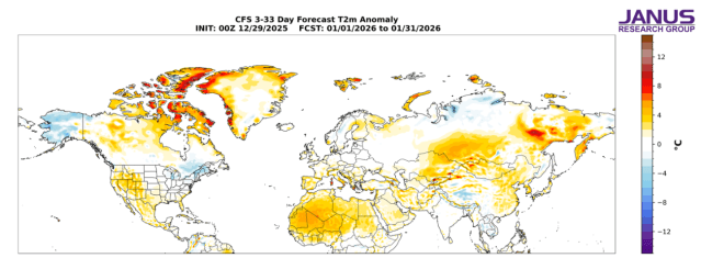
Forecast average surface temperature anomalies across the Northern Hemisphere for January 2025
Goodbye, Seattle of the North
What a difference a few years can make in Alaska.
Five years ago, the New Year’s Eve view from top of the Hotel Captain Cook in downtown Anchorage was that of Seattle today, or maybe a slightly warmer Seattle.
Well after dark at the start of 2020, the Anchorage temperature was still at 45 degrees with rain splattering down on snow-free streets.
Alaska was then enjoying or – depending on one’s view of snow and cold – suffering through a string of unusually warm winters that had a lot of folks talking about Anchorage becoming the Seattle of the North.
Weather patterns over the North Pacific Ocean had changed and warm air from the tropics, those then well-known Pineapple Express, regularly came roaring north across the Gulf of Alaska to slam into the state’s urban underbelly.
Climate scientist Daniel Swain – a postdoctoral fellow in the Institute of the Environment and Sustainability at the University of California, Los Angeles – in 2017 credited this phenomenon to what he labeled the “Ridiculously Resilient Ridge (The Triple R)” above North America’s West Coast, disrupting the normal east to west flow of the so-called jet stream six to nine miles above the planet’s surface.
And Anchorage wasn’t the only hotspot in the 49th state.
As the winter of 2017-2018 began, the residents of the northernmost city in the United States were still cleaning up in the wake of a fall storm that came roaring across a strangely ice-free Arctic Ocean to pound their low-lying community, a community made famous in early October of 1988 because a trio of gray whales got trapped in the ice offshore.
Where the ice was in 1988 a foot thick, there was no ice in 2017.
Swain and his colleagues blamed the Triple R, wihch they first noticed in 2013 and documented regularly for years after.
“Atmospheric pressure patterns similar to the Triple R are now occurring more frequently than they did in previous decades,” Swain wrote in a peer-reviewed paper published in Climatology in 2016, and “the unprecedented magnitude and persistence of recent West Coast ridging can be traced (at least in part) to regionally-accentuated warming of the lower atmosphere.
“To date, the strongest evidence appears to implicate unusually warm ocean waters in the tropical western Pacific, which can trigger a hemisphere-scale wave pattern favoring an enhanced subtropical ridge near California,” he wrote “(But) other work has suggested that unusually warm ocean conditions in the “extratropical” Pacific (i.e. the so-called “Warm Blob” in the Gulf of Alaska) may also be linked to the persistent ridge – though there’s considerable evidence that the atmospheric Triple R caused the oceanic Blob, rather than the reverse.
“Still others have wondered whether the striking loss of Arctic sea ice in recent years may have played a role, though the evidence supporting this connection remains sparse. Finally, it has also been shown that random variations in the atmosphere can occasionally produce an extremely persistent North Pacific ridge. In other words: the Triple R may be at least partially attributable to ‘bad luck.’”
Bye-bye Triple R
There were reasons to believe the Triple R might become the norm. It fit well with early climate-change models that predicted global warming would make Juneau ever more like Seattle and Anchorage ever more like Juneau.
And then along came those damn weather variations that can make one year look whole different from another year by shifting the norm by a seemingly few degrees. This year Anchorage is feeling more like Fairbanks and Juneau more like Anchorage, though the National Weather Service reports the state’s largest city was only about 6 degrees colder than the long-term norm for December.
Then again, there was that pre-Christmas cold snap that left a big impression on everyone with temperatures 21 degrees below normal on Dec. 21 and 22 before warming up to a comparatively balmy 15 degrees below normal on Christmas when the high temperature climbed three degrees above zero for the day.
And some wonder why the country is home to so many global-warming skeptics. It is hard for many to ignore the wide and normal variations in weather, and it the media’s climate change hysteria, which tries to link these variations to global warming, doesn’t help because the planet has been warming.
This is near the lower end of most climate models, but Christy has long been labeled a “climate-change denier,” primarily because of his belief that the forces driving global warming are more complex than sizeable increase in carbon dioxide in the atmosphere since the beginning of the Industrial Revolution.
Christy “disagrees with the use of the term ‘denier,’” the news group said. “(But) Christy argues that reducing carbon emissions would have little impact on climate change and is a critic of efforts to mandate reduction of carbon emissions.”
Spencer takes a somewhat similar view, but has not been nearly as controversial as Christy who some view as a tool of the fossil fuel industry.
That may be true. Then again, it may not. Predicting the future is hard.
As Spencer himself observed in 2016, “there is widespread consensus that humans contribute to…global warming, a position that the vast majority of climate ‘skeptics’ agree with – including myself. I do not know of any climate skeptic researchers who claim that humans have no influence on the climate system. The existence of trees has an influence on the climate system, and it is entirely reasonable to assume that humans do as well.
“(But) the most pertinent questions really are: (1) just how much warming is occurring? (not as much as predicted); (2) how much of that warming is being caused by humans? (we don’t really know); (3) is modest warming a bad thing? (maybe not); and (4) is there anything we can do about it anyway? (not without a new energy technology).”
He argued those are questions that need to be dealt with, but added that “when I have discussed the evidence for natural causes of climate change with ‘consensus’ researchers, they inevitably retreat to the position that ‘we need to get away from fossil fuels anyway.’
“…It should concern us that researchers, who should remain unbiased, are so easily swayed by their perceptions of energy policy that it would affect the way that their science is presented.”
Maybe it should. Maybe it shouldn’t, because obviously the world has to rid itself of fossil fuels at some point. They are, everyone agree, non-renewable resources that can’t last forever, making the argument for a shift to renewable energy sources a wholly reasonable one.
Why? Becuase the eventual end of non-renewable energy is predictable as the water draining out your bathtub when you open the drain. And climate change?
Well, it’s as predictable, or more accurately unpredictable, as the weather Alaska is getting this year. When the national Climate Prediction Center (CPC) issued its winter climate forecast, it called for “warmer-than-average temperatures across much of the East Coast, Southeast, Gulf Coast, Texas, the Southwest, California, and Northwestern Alaska,” with drier-than-average conditions are favored for portions of the Mid-Atlantic, Southeast, Gulf Coast, Texas, the Southwest, California, and southeast Alaska.”
As noted above, Juneau is now digging out from under feet of snowy precipitation, and the the temperatue today in the Northwest city of Kotzebue is 14 degrees below zero and predicted to drop to 26 below by Saturday night.
The long-term “normal” temperatures for Kotzebue call for a high of seven and a low of minus five on New Year’s day. Kotzebue will end the day 19 degrees shy of the normal high, and the overnight low is predicted to come in 14 degrees below the normal low with the temperatures only falling until Sunday when the temperatures start to climb as some snow moves in.
That is expected to bring the temperature up to minus 8 by Monday. That will be about 15 degrees colder than the normal high for the day and three degrees colder than normal low. Judah Cohen, an MIT professor and authority on the polar vortex which whirls above the North Pole and influences winter temperatures and snowfall across the entire northern hemisphere, is predicting below normal temperatures will continue thorugh the month.
But hey, there’s always hope for February, and there is that old Alaska weather rule: Blink twice and the weather is likely to change.
And whatever the case, it appears that any discussions of Anchorage as the new Seattle of the North are now pretty much dead.