
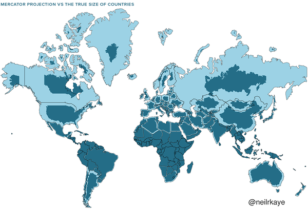
Lately, I’ve noticed that many people have forgotten some of the things from elementary school, and maybe it’s good to remember them, since more and more often people discuss world politics or have conversations about other countries. I am attaching a map of the actual size of the countries, which are mostly deformed on the mercator projection. Of course, everyone probably remembers this from elementary school, but after years of looking at distorted maps, it can still affect a person psychologically.
I’m giving it as a flare 💩post because I don’t want to disrupt important discussions. Please modi don’t download it, it’s important to repeat it and remind your family and friends.
https://i.redd.it/d86vfrczbfbg1.png
Posted by [deleted]
11 Comments
hej no Merkator je dost na picu hlavne pri porovnani Gronska a Afriky…
ale stale jeden z mojich oblubenych geografickych fun factov je ze ked este existoval Sovietsky Zvaz a Pluto bola planeta tak Sovietsky Zvaz mal rozlohu na “planetarnej urovni” (viac km^2 jak povrch Pluta)
r/WeKnowAboutMercator
Kolega bol veľmi smutný, keď som mu ukázal, že Rusko a Čína sú menšie 😀
Antarktída gde?
Urodny pas afriky je vacsi ako cela europa. Ale treba pomahat lebo afrika je tak neurodna
https://thetruesize.com/#?borders=1~!MTU1NDk4MzI.MjE3MTc1NA*MjYwMjg3NjQ(MTMzNzI1MTQ~!CONTIGUOUS_US*MTAwMjQwNzU.MjUwMjM1MTc(MTc1)MQ~!IN*NTI2NDA1MQ.Nzg2MzQyMQ)Mg~!CN*OTkyMTY5Nw.NzMxNDcwNQ(MjI1)Mw
Nový Zéland je, Island je, mapa je v poriadku
Jj, trump chce gronsko lebo pozna len mercatorovo zobrazenie. So huuuge!
Can I get any more of them PIXELS?
[Google earth](https://earth.google.com/web/), nemáte za čo.
To je preto, lebo merkatorove vykreslenie mal účel zachovať uhly pre námorníkov.