

At least six people have died as a severe cold snap hit many parts of Europe with heavy snow, ice, and sub-zero temperatures across Europe starting Monday, January 5.
The Arctic outbreak caused multiple accidents, flight cancellations, and train disruptions across France, the Netherlands, the United Kingdom, and the western Balkans.
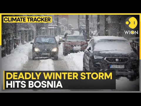
Five fatalities were reported in France following multiple collisions caused by icy roads and black ice, including several crashes in the southwest and in the Paris region. The sixth fatality was a woman who died in Sarajevo, Bosnia and Herzegovina, after being hit by a tree that collapsed under the weight of the snowfall on Monday.


The cold air mass, originating in the Arctic and spreading south through Scandinavia, has brought one of the most significant early-January cold events in recent years.
Temperatures dropped sharply across western and central Europe over the weekend. The United Kingdom recorded lows of −12.5°C (9°F) in parts of eastern England, the coldest so far this winter. Northern and central France registered temperatures near −10°C (14°F), while the Netherlands and Belgium reported night-time lows between −6°C and −9°C (21–16°F).
Heavy snowfalls affected northern France, the Low Countries and parts of Germany, disrupting transport and grounding hundreds of flights.
Paris–Charles de Gaulle and Orly airports operated on reduced schedules as snow removal and de-icing operations continued throughout Monday. Amsterdam’s Schiphol Airport temporarily suspended all departures and arrivals due to poor visibility and frozen taxiways grounding around 600 flights. Train services across the Netherlands were halted early in the day because of ice accumulation on overhead power lines and frozen track switches.
Météo-France maintained cold weather and snow-ice alerts for much of the country and activated additional measures to shelter homeless and vulnerable populations as part of its winter contingency plan. In Paris, emergency shelters extended capacity overnight as wind chill values pushed perceived temperatures well below −10°C (14°F).
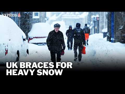
Across the United Kingdom, the Met Office issued yellow and amber warnings for snow and ice across England, Scotland and Wales. Snow accumulations reached up to 20 cm (8 inches) in higher terrain of Yorkshire and the Scottish Highlands. Freezing rain led to localized ice accretion on power lines and trees, resulting in scattered power interruptions. Several mountain roads were closed due to drifting snow and near-zero visibility.
In central Europe, Germany, Poland and Czechia experienced widespread frost and moderate snowfalls. Berlin recorded lows near −9°C (16°F) overnight, with freezing fog and black ice reported across Brandenburg. The Polish Institute of Meteorology and Water Management noted snow depths up to 15 cm (6 inches) in southern and central regions.
In the western Balkans, heavy snow and strong winds disrupted transport and damaged power lines. Sarajevo recorded about 30 cm (12 inches) of snow within 24 hours, while Zagreb measured around 20 cm (8 inches). Snowdrifts blocked mountain passes and caused power outages in several rural communities.
The Arctic wave is associated with cold, stable high-pressure over northern Scandinavia, combined with a trough over the Mediterranean, which maintains persistent northeasterly flow and below-normal temperatures across much of the continent. The resulting temperature anomaly remains 8–12°C (14–22°F) below average in several regions.
Forecasts indicate the cold pattern will persist through mid-week before gradually easing from the west. Météo-France expects continued sub-zero temperatures until at least Friday, with daytime highs in northern France remaining between −3°C and 0°C (27–32°F).
The UK Met Office forecasts further snow showers in eastern England and Scotland through Thursday, followed by a gradual shift to milder maritime air later in the week.
The ECMWF model suggests a weakening of the Arctic high toward the weekend, allowing Atlantic fronts to bring warmer and wetter conditions to western Europe. However, residual cold air over central and eastern Europe may sustain below-average temperatures and intermittent snow through the second week of January.
Authorities continue to advise caution due to persistent icy surfaces and snow accumulations. Traffic restrictions remain in effect in parts of France and the Netherlands, while German and British transport agencies are urging drivers to postpone non-essential travel. Energy consumption has risen sharply as heating demand increases, with utilities reporting peak usage levels for the season.

On January 6, Météo-France officially named the system Storm Goretti, the first European windstorm of the year. The designation applies to the same Arctic outbreak that has brought snow, ice, and sub-zero temperatures across much of the continent since January 5.
As Goretti advanced eastward from the Atlantic, it deepened over northern France and the United Kingdom, producing additional heavy snowfall, freezing rain, and strong winds on January 7.
National meteorological agencies maintained widespread snow and ice warnings, with gusts locally exceeding 130 km/h (80 mph) along exposed Atlantic coasts. Transport disruptions continued in France, the Netherlands, and the UK as the storm’s impacts intensified.
References:
1 At least six dead as cold snap grips Europe with snow and ice wreaking travel havoc – Euronews -January 6, 2026
2 Six people die as snow, ice and freezing temperatures wreak havoc in Europe – The Guardian – January 6, 2026
3 Snow and ice wreak havoc across Europe, causing deadly accidents and travel chaos – AP – January 6, 2026
4 Western Europe braces for another wave of snow and ice – Reuters – January 7, 2026