

As city and state officials monitor the forecast and pre-treat roadways, emergency management officials from Philadelphia, New Jersey and Delaware are encouraging residents to stock up on basic supplies and avoid nonessential driving when possible during the storm.
For those who must, here’s how to best prepare for winter driving, and what to keep in your car.
Philly public schools will be closed Monday
City public schools will be closed on Monday due to inclement weather. Charged Chromebooks will be sent home with students on Friday. After Monday, if needed, the School District of Philadelphia will shift to virtual learning.
Philly archdiocesan schools will utilize ‘flexible instruction’ on Monday
Archdiocesan high school and parochial elementary school buildings will be closed on Monday; those schools will utilize “Flexible Instruction Days,” the Archdiocese of Philadelphia announced Friday.
Students and parents should refer to their local school website for further details.
What’s the latest forecast?
Philadelphia may see its first double-digit snowfall in more than 10 years.
The region could get as much as 18 inches of snow and sleet, according to the National Weather Service’s Mount Holly branch. Snowfall rates near 1-2 inches per hour are expected during the daytime on Sunday.
Precipitation will likely mix with or change to sleet and freezing rain from south to north inland into the I-95 corridor, and potentially as far north as the I-79 corridor starting Sunday afternoon.
Higher snowfall is anticipated farther north. Cities including Philly, Trenton and Wilmington may see snowfall between 8-12 inches. Cape May could see 6-8 inches, and Bethany Beach could see 4-6 inches.
Heavy snow and ice accumulation will make travel dangerous or impossible, the NWS reports. Snowfall, followed by sleet, freezing rain and 20-30 mph wind gusts, could also result in downed trees and power outages.
Ice accumulations may range from 0.1” to 0.3” across the I-95 corridor, South Jersey, and northern Delmarva.
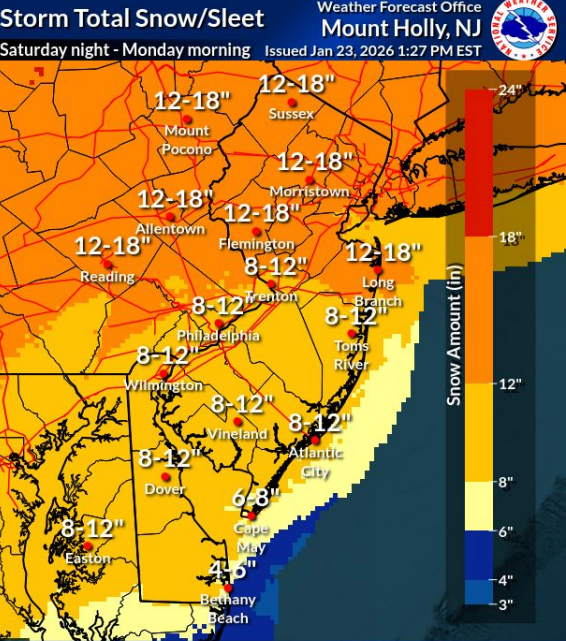 A National Weather Service forecast map shows the Philadelphia region is anticipating heavy snowfall this weekend. (NWS)
Forecasters with WHYY News partner 6abc show more conservative estimates, with Philadelphia expected to see between 8 to 10 inches of snow on Sunday.
After the storm passes, a prolonged period of “well below normal” temperatures is expected to stick around next week, with wind chills in the single digits to below zero each night.
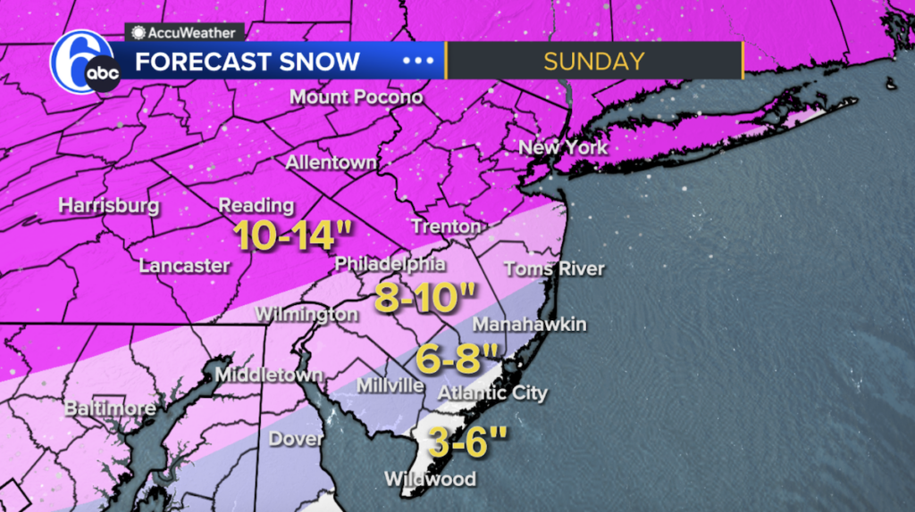 Heavy snowfall is in the forecast for the Philadelphia region. (6abc)
Weather alerts, watches and advisories
A Cold Weather Advisory will be in effect from midnight Friday through 10 a.m. Saturday for the counties below, with “very cold wind chills” as low as 8 below expected, per the National Weather Service.
- Pennsylvania: Delaware, Philadelphia
- New Jersey: Atlantic, Burlington, Camden, Cape May, Gloucester, Cumberland, Ocean, Salem
- Delaware: Kent, New Castle, Sussex
A Winter Storm Warning will be in effect for the following counties from 7 p.m. Saturday through 1 p.m. Monday, with heavy and mixed precipitation expected, along with ice accumulations around three-tenths of an inch.
- Pennsylvania: Chester, Delaware, eastern Montgomery, Philadelphia
- New Jersey: Atlantic, Burlington, Camden, Cape May, Cumberland, Gloucester, Salem
- Delaware: Kent, New Castle, Sussex
Significant ice accumulation on power lines and tree limbs may cause widespread and long-lasting power outages, per NWS, and travel could be “nearly impossible.”
Enhanced Code Blue in Philly
An Enhanced Code Blue is in effect in Philadelphia until further notice.
During extreme cold — when temperatures feel near or below 20 degrees Fahrenheit, or when there is precipitation and the temperature is 32 degrees Fahrenheit or lower — Philadelphia officials will declare a Code Blue.
During a Code Blue event, the city implements special measures to keep people who are experiencing homelessness safe. Those measures include 24-hour outreach to find unhoused people and transport them to safe indoor spaces and opening all available beds within the city’s emergency housing network for those in need.
The 15 warming centers below are open amid the current Code Blue.