

A Nor’easter is expected to hammer parts of Hampton Roads and northeastern North Carolina with heavy winds and icy cold this weekend, but the National Weather Service has adjusted some expected snow totals downward across the region.
A winter storm warning is in effect through 7 p.m. Sunday for Norfolk, Portsmouth, Chesapeake, Virginia Beach, Suffolk, Newport News, Hampton and York County, as well as portions of northeastern North Carolina and areas to the west of Hampton Roads.
As of Saturday afternoon, the expected snow totals dropped in most of Hampton Roads. The weather service says Norfolk, Portsmouth, Suffolk and most of Chesapeake and Virginia Beach is likely to see 3-4 inches of snow.
Northeastern North Carolina is still expected to see the heaviest snow of the region — 7-9 inches or more.
Areas on the Peninsula are likely to receive less snow. The Williamsburg area is likely to see an inch over the weekend, the weather service said Saturday afternoon. Newport News and Hampton are likely to see 2-3 inches.
The highest totals are expected in the far south and southeast, with a sharp cutoff in totals to the north, the forecasters said. Totals could go from 1 inch to 6 inches in less than 50 miles.
National Weather Service meteorologist Andrew Zimmerman said moisture was encountering dry air as it attempted to move north across the region Saturday afternoon.
“We should see some of that moving up, especially into southside Hampton Roads, as we get through the afternoon and evening hours here,” Zimmerman said.
Snow is likely to begin accumulating in Hampton Roads on Saturday afternoon, grow throughout the day and peak early Sunday morning, with snow ending later Sunday morning, according to the weather service.
Areas near southeastern Virginia and northeastern North Carolina could see brief whiteout conditions late Saturday into Sunday.
“This one has so much cold air to work with in the entire column of the atmosphere that we’re looking at a very dry snow, very powdery, which is good for power lines and trees,” meteorologist Roman Miller said Friday. “Winds will potentially be an issue.”
Dominion Energy said Friday it was preparing for “thousands of potential outages” in Hampton Roads and the Outer Banks, said spokesperson Cherise M. Newsome.
In addition to the winter storm warning, the region is under a high wind warning from 7 p.m. Saturday to 4 p.m. Sunday, a cold weather advisory through 1 a.m. Sunday, an extreme cold watch from 1-10 a.m. Sunday, and a coastal flood watch from 4 a.m.-1 p.m. Sunday.
The weather service gives Norfolk a 56% chance of at least 4 inches of snow — down significantly from earlier this week — and about 30-60% for the Peninsula and Eastern Shore. The likelihood of snow increases farther south into northeastern North Carolina — Elizabeth City has a 83% chance of seeing at least 4 inches.
The likelihood of 8 inches or more in most of Hampton Roads has dropped to low. Norfolk has a 21% chance of 8 inches. Parts of Virginia Beach have a slightly higher chance. The Peninsula is unlikely to see that much snow.
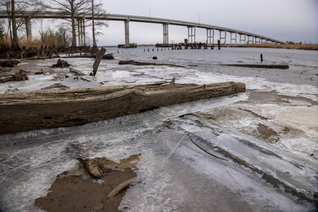 Ice formed on the shore of the North Landing River near the Pungo Ferry Road bridge in Virginia Beach Saturday. (Peter Casey / The Virginian-Pilot)
“Definitely prepare for strong wind gusts, especially right along the immediate coast,” Zimmerman said Thursday.
Maximum wind gusts could reach 58-60 mph in Corolla early Sunday morning. Gusts in Virginia Beach and Cape Charles also are expected to reach near 60 mph. Farther inland, winds will be in the mid-40 mph range, dropping down to the mid-30 mph range in the Williamsburg area.
Wind chills could hit negative degrees in parts of the region. The wind chill in Williamsburg could hit minus-2 degrees, while Hampton and Newport News could see 2 below. Norfolk and Portsmouth’s lowest wind chill projection is 0 while other areas of South Hampton Roads are likely to be in single digits.
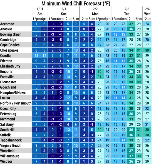 Virginia could see dangerous wind chills on Saturday night and early Sunday morning, according to the National Weather Service. Updated through 9 a.m. Saturday morning, Jan. 30, 2026.
With it being so cold, the snow is likely to linger “for a while,” Zimmerman said, adding that areas still dealing with ice from last weekend will have those impacts prolonged.
Tidal flooding could also have an impact Saturday night into Sunday. Moderate to major local tidal flooding is possible in vulnerable coastal areas, as is beach and dune erosion. Because of the cold, any tidal flooding could freeze on road surfaces.
Virginia Department of Transportation crews began pretreating state-maintained roadways on Thursday.
Due to forecasted strong winds, snow, and potential tidal impacts, the Jamestown-Scotland Ferry may suspend service at points during the storm, VDOT said in a news release.
-

Virginia Beach Public Works employees prepare brine to be spread on the roads prior to this weekend’s impending snow storm. As seen Friday, January 30, 2026. (Stephen M. Katz / The Virginian-Pilot)


1 of 5
Virginia Beach Public Works employees prepare brine to be spread on the roads prior to this weekend’s impending snow storm. As seen Friday, January 30, 2026. (Stephen M. Katz / The Virginian-Pilot)
Gavin Stone, 757-712-4806, gavin.stone@virginiamedia.com