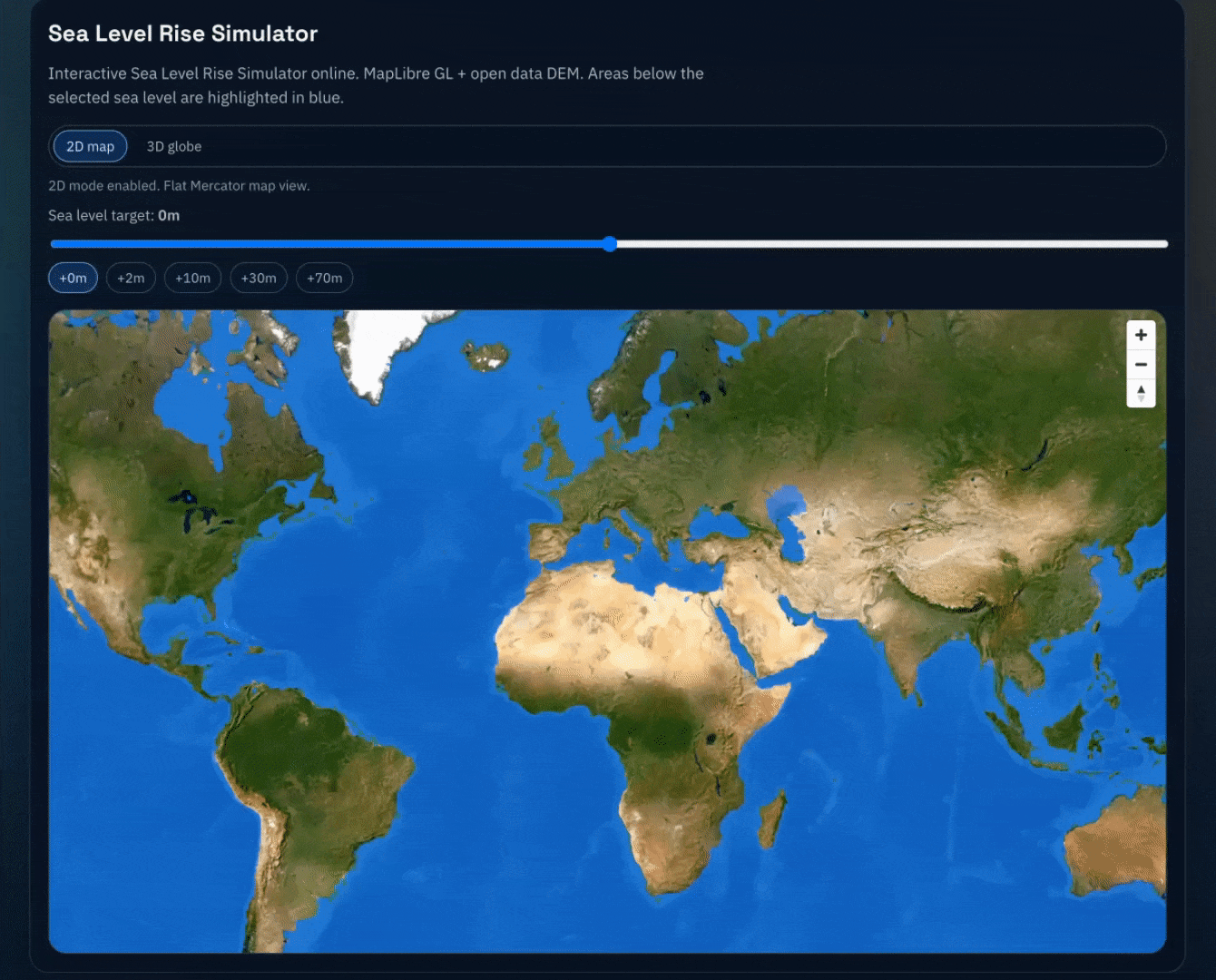
I created an interactive simulator on map allow you to see how the sea level rise/drop will influence on the earth. welcome to have a try.
Posted by Sudden_Beginning_597

![[OC] Sea level simulator visualization](https://www.byteseu.com/wp-content/uploads/2026/02/bpzbkj49q1mg1-1024x825.gif "[OC] Sea level simulator visualization")
I created an interactive simulator on map allow you to see how the sea level rise/drop will influence on the earth. welcome to have a try.
Posted by Sudden_Beginning_597
26 Comments
https://preview.redd.it/a658bpiar1mg1.png?width=2410&format=png&auto=webp&s=1d5b9446d7a8d31ab77ef854d22bcf88acaab478
Just for fun, sea level simulator on Mars
Funny how my country already half disappeared with +0. The concept of water management is probably to difficult to add.
It’s a shame we can’t flood France without flooding the uk. We’ll have to find another way.
How accurate is this though. If you go to 30m, then you end up with a sizeable inland lake in Australia. But I don’t think just having rising sea level would mean that you’d get an inland lake. It looks like they just grew Kati Thanda-Lake Eyre which is an Endorheic lake, which mean that it has no outlet. Would rising sea levels make lakes like this bigger? How would the water get in there?
add and easter egg where netherlands doesnt sink no matter what
Interesting. Sea level need to rise +12m for Stockholm to return to normal. (I’m sure there’s a good and interesting explanation to this, so not a complaint to OP.)
This was done in googles aistudio?
Oooo, it’s very cool how much you can zoom in to see the local effects as well as the global ones.
While fun, I’m pretty sure that there’s nowhere near enough water in the world to raise the level by 1km XD
https://preview.redd.it/6sr2hi8dx1mg1.png?width=2296&format=png&auto=webp&s=ba1531c3a2a9635906770b96476556d8daa1c5d4
The Netherlands is already underwater at 0m 😉
https://preview.redd.it/0u4u5nlqx1mg1.jpeg?width=1179&format=pjpg&auto=webp&s=a9068fa5dbac836eeb38ae7ffb92fa46a976c669
That seems off somehow. The wash is below sea level?
Pull the slider all the way to the right. *(Cue Waterworld Music)*
Whew… My house is good for another 164 m in sea level rise!
I am good up to about 10m rise
Netherlands should never go under water
I just need to wait until we are at 1462 meters rise to get a beach front house.
Something is up with the zoom I think maybe. When I zoom in at the city neighborhood level, land masses seem to rise so there are now dry spots in the nearby river. And then zooming all the way out at the same “sea level,” Greenland gets a lake in the middle.
To save anyone interested from a Google search: if all the ice on earth melted, sea level would be 216 ft/65 m. So any scenario where sea level rises substantially further than that involves the kind of cataclysmic disaster we probably couldn’t survive anyways
https://legacy.geog.ucsb.edu/what-if-all-the-ice-melted-an-interactive-map-from-national-geographic/
Finally the blue planet everybody talked about.
Loved watching my job disappear under the water before my home.
It’s missing some of the Canadian lakes, but it looks cool
FYI estimated sea level rise by 2076 (50 years) is under +1m
I used something like this to decide where to move for retirement.
I like how your waterway identification/management gives Lake Superior an independent upwelling as global levels rise
Woooo! 100m on the dot and I own lakefront property!
As a bit of feedback, give an option to enter numbers manually. The slider is very hard to use for single digit entries. Neat tool though!