

If El Niño were a circus act of death-defying acrobatics, the superlatives gasped by astonished observers would have people queuing up for tickets.
Experts who normally speak in reserved scientific terms have declared it super, unprecedented, remarkable, record-breaking and jaw-dropping.
It’s a Godzilla-like blockbuster, some say, unlike anything in living memory.
But El Niño is no entertainment event, and we are all trapped in its arena, whether or not we want to be there.
Ireland will not necessarily have a front-row seat: those are reserved for countries in Asia, Africa and Central America.
But if this Niño plays out the way it is predicted, nowhere will remain entirely untouched.
The World Food Programme says 50 million people will experience acute hunger as El Niño-related drought and floods kill crops and raise prices in vulnerable regions.
Save the Children updated its forecast for southern and eastern Africa this week, warning eight million children were at risk.
The Climate Impact Lab at University of Chicago has projected that 450,000 people will die of heat-related conditions by next spring.

A Pacific Ocean wave washes up near damaged beach front homes in Danam Point, California. Photograph: MarioTama/GettyImages
The governor of California, Gavin Newsom, declared a state of emergency last Tuesday in preparation for anticipated battering by rain, wind and snow.
Australia’s National Emergency Management Agency, meeting in the past fortnight, warned of increased bushfires in territories where the incoming summer risk is always high to begin with.
The UK government gathered experts to assess the implications and last week produced a list of dozens of potential impacts for which preparations should be made.
Official reaction in Ireland has been muted by comparison.
Labour TD Ciarán Ahern, the party’s climate spokesman, raised the issue in the Dáil when it resumed after the summer break last week but his questions failed to ignite debate.
Taoiseach Micheál Martin, speaking at a side event at the UN General Assembly in New York this week, did at least acknowledge it.
Announcing a programme of supports to combat child malnutrition across Africa, he said: “The escalating food crisis, driven by conflict and the impending super El Niño weather event, has left the world on the brink of a historic hunger emergency.”
Otherwise there has been little indication of Government concern around what the World Meteorological Organisation warns will be the strongest in modern times.
“This exceptional El Niño demands exceptional preparation and response,” WMO secretary general Celeste Saulo said earlier this month.
The Government Taskforce on Emergency Planning, the body that appears best suited to take charge of such preparation, has not met to discuss the issue.
The Department of Housing said, if required, it would co-ordinate a “whole-of-Government response” to severe weather or flooding through the National Directorate for Fire and Emergency Management, which it chairs.
“[The directorate has] also liaised with government departments and agencies to facilitate preparations ahead of the upcoming autumn-winter season,” the department said.
“This was undertaken in close collaboration with local authorities and Met Éireann.”
[ Additional heat from El Niño projected to cause 450,000 deaths in next six monthsOpens in new window ]
Keith Lambkin, head of Met Éireann’s climate services division, says there has been no request to brief any Government grouping specifically on El Niño.
He stresses that does not signal indifference.
“Just because we’re not jumping up and down in Met Éireann shouting about it the whole time doesn’t mean we’re not paying attention to it,” he says.
“It’s just that it is actually captured in the development of the weather systems that we’re already monitoring, which then feed into existing forecasting and warning systems.
“It’s not that we’re ignoring it, it’s that we are already capturing it.”
But what exactly is this monster they are capturing? El Niño is a climate phenomenon that occurs naturally, every two to seven years.

El Niño map
Its hallmarks are heat, its method is chaos and its legacy is damage, primarily by disturbing rainfall, particularly in countries where there are large seasonal shifts in rain patterns.
Monsoon regions are a classic example. They expect prolonged, heavy rains at a certain time of year and build their agriculture, homes, livelihoods and customs around that.
Then along comes an El Niño and the monsoons are shorter and lighter – in some cases, dramatically so.
Rains fail entirely in some countries while others are pounded by devastating floods.
The ripple effect is felt worldwide in disruption to weather behaviour and climate patterns.
These are behaviours and patterns already out of kilter because of the underlying heating generated by burning fossil fuels.
A super strong El Niño on top of a world struggling with climate change make for a lethal combination.
[ How worried should we be about this year’s ‘Super-Duper El Niño’?Opens in new window ]
And yet this extra surge in instability all stems from just one patch of one ocean, the waters of the tropical Pacific that lie roughly between Indonesia and Central America.

Drought in Indonesia: a villager carries a bottle of spring water after collecting it at Gunung Batur village in Cilegon, Banten province, in July. Photograph: Bay Ismoyo/AFP via Getty
Most of the time, the giant trade winds blow from Central America towards Asia, bringing with them warm waters that are replaced by the upwelling of colder waters from the deep ocean.
But in an El Niño, the winds slacken or reverse, the waters become more static and the heat builds up in them.
Michelle McCrystall, a climate scientist and assistant professor at Maynooth University, likens the effect to that of a pot of boiling water.
“When you get a real good pot of boiling water and the whole thing’s bubbling the whole depth of the water, that’s what’s happening with an El Niño,” she says.
If left on the heat, the boiling becomes more vigorous and the lid starts moving around, she says.
The steam might lift the lid completely – up to a point that in real life would be the tropopause, the layer of Earth’s atmosphere where our weather stops.
But the pot is still bubbling so the steam keeps coming and when it can’t push the lid any further, it spreads out all around, eventually steaming up the whole kitchen.
In the same way, this patch in the Pacific spews out huge amounts of heat and energy that interfere with cloud and storm formation and obstruct the normal flow of air and sea currents, with knock-on effects for weather everywhere.
“The pot is relatively small but the force is so large and intense that it’s affecting everything,” says McCrystall.

Michelle McCrystall
The heating of the ocean in this El Niño is extraordinary. The WMO said the main waters were 3.5 degrees above normal temperature but, in some places, were eight degrees higher.
In the natural world around us and the atmosphere above us, a half degree of extra heating can send chemical reactions haywire.
The mayhem eight degrees could cause is hard to fathom, hence the loss of suitably strong scientific words to convey it. “Godzilla” barely covers it.
[ Forecaster predicts strongest El Nino in living memoryOpens in new window ]
But will the monster stomp over Ireland or will we just feel the tail-end of the tremors its rampaging creates?
Previous strong El Niños hint at a pattern. Winter 2023-2024 was, according to Met Éireann records, “mild and wet overall with six named storms”.
Winter 2015-2016, another El Niño period, was also “wetter and milder than normal everywhere, with six named storms”.
The 2009-2010 El Niño was different, coinciding with a big freeze in Ireland.
But the 1997-1998 El Niño, like others, brought mild, wet weather and repeat storms that struck with memorably bad timing over Christmas.
However, it is worth noting that last winter, with no El Niño, was also mild with weeks of nonstop rain and significant flooding in parts.
The WMO says this El Niño will raise temperatures everywhere, but Keith Lambkin prefaces any more detailed forecast for Ireland with a well-worn warning.
The country’s geographic position, as an island stuck out in the Atlantic, leaves our weather exposed to many influences and prone to rapid fluctuations.
“The seasonal forecast in our part of the world, just because it’s so dynamic, usually isn’t brilliant,” he says of the meteorologist’s holy grail: an accurate three-month forecast.
“But what the seasonal forecasts are showing at the moment is a signal for a better-than-average chance of getting wetter, unsettled conditions.
“You still wouldn’t bet your house on it but it’s a stronger signal than we’re used to seeing.”
[ Why is this El Niño set to be so strong and what will its effects be in Ireland?Opens in new window ]
After last winter’s floods and the previous winter’s Storm Éowyn, the National Directorate for Fire and Emergency Management should be prepared for a similar serving from El Niño if that is what transpires.
But El Niño has implications for more than just the national weather.
The UK’s impact report looks at the bigger picture, one that applies equally to Ireland.
“Secondary effects of El Niño on global food supply chains have the potential to reduce yields and drive up prices,” it says.
It highlights rice, coffee, cocoa and olive oil as products likely to be affected but the impacts could be wider.
“Around 50 per cent of food in the UK is imported, including around 80 per cent of fruit and vegetables, often from countries such as Spain and Morocco, where El Niño could exacerbate drought,” it says.
“Supply of affected commodities to the UK will likely continue, but reduced global yields are expected to result in higher prices for consumers.
“Changing weather patterns caused by El Niño could increase global demand for liquefied natural gas (LNG), placing additional pressure on a global market already facing uncertainty from the Ukraine and Middle East conflicts.”
Ireland does not use LNG but any pressure on the fuel will have knock-on effects on the market for conventional gas on which Ireland relies heavily.
Since this assessment, restrictions on traffic through the Panama Canal have been announced as water levels fall due to drought, with implications for international trade.

A man cools off in a public fountain amid high temperatures linked to the El Nino weather phenomenon in Cali, Colombia, on Wednesday. Photograph: Joaquin Sarmiento/AFP via Getty
Derarca Dennis from EY consultants coaches businesses on climate change preparedness and sustainability through EY’s Four Futures programme.
Lately she has been adding El Niño to her workshops.
“It mightn’t be as wild for us as other countries but we will have uncertainty and we will have weather disruption,” she says. “Even if the extreme events are in other jurisdictions we will be disrupted because of our dependence on trade. We are a globalised economy.
“Some sectors are ahead in their thinking on this. If you look at the pharma sector, for example, they are very well advanced, partly because they’re globally traded but also because their goods have significant value.
“Losing a shipment of pharma because of a storm or a hold-up is extremely expensive.”
Dennis says businesses also need to be more aware of local impacts.
“The business community relies on infrastructure to be functional, so if a road is blocked or a train can’t run, that is hugely disruptive.
“Look at what happened in Killarney in August where there was an hour of rain, and – boom – the town’s flooded. El Niño will bring more of this. We have to ask: how will we deal with it?”

Derarca Dennis, head of climate change and sustainability services at EY consultants
She says businesses are gradually becoming more aware of climate-related challenges. Temperatures in the 20s in late September help focus attention.
“We have to see it to believe it. One participant asked yesterday: when are we getting autumn? That’s the kind of change people notice.”
But she thinks the penny has still to drop with many – and maybe ugly potatoes will help.
“We waste a lot of food – we throw out food because it’s not pretty. But we are heading into a winter where we’ll have less food – there’s a shortage of potatoes, for example.
“So the ugly potatoes will be coming on to the table and I like that idea because it will create a conversation. Maybe our ugly vegetables will make us realise that, actually, something’s happened here.”
In Somalia, no such epiphany is needed. The last El Niño, in 2023-2024, came after five failed rainy seasons brought millions to the brink of starvation.
In a rapid and devastating reversal, El Niño brought torrential rains and lethal floods.
“One of the reasons we’re so worried is that Somalia is just coming out of another multi-season drought,” says Richard Nunn, country director with Concern, from Mogadishu.
“We have six million people in emergency food insecurity status and 1.88 million children under five are acutely malnourished, so we’re already at a stage where communities are very vulnerable.
“Crops have been failing, people have been moving, livestock are weak and, given the prolonged dry spell, the ground is packed solid hard.
“When we have normal rainy seasons, communities are able to plant. When you have an El Niño phenomenon, we risk severe flooding and it washes away the crops.
“It can cause people to lose their houses and their belongings, break critical infrastructure, schools can be flooded, health centres can be flooded.
“The last El Niño was in 2023 and we saw quite severe impacts from that, and this one is forecast to be more serious.”
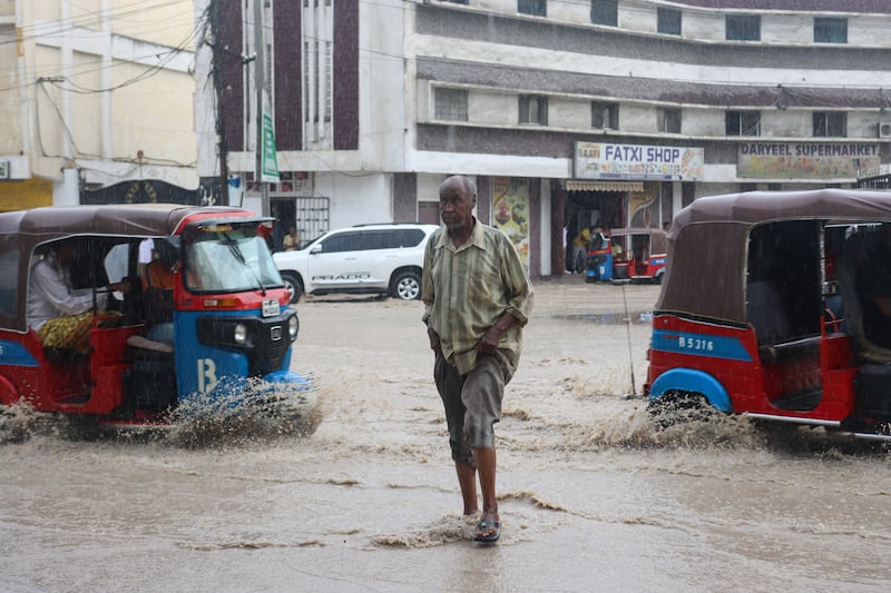
Flooding in Mogadishu, Somalia, 2023. Photograph: Said Yusuf Warsame/EPA
The rains are due in a few weeks, and preparation is under way in case they turn deadly.
“It includes planning for relocation, pre-positioning supplies including health supplies and education supplies, and getting cash.
“We’re helping communities clearing drains, digging channels and putting sandbags in place around critical water infrastructure, but there are limits to the funding available and there are limits to what you can feasibly do.”
Funding is a serious concern. The US previously funded half Somalia’s humanitarian aid, and since Donald Trump cut off assistance, other countries have reduced their contributions.
Irish Aid’s support has remained firm, but it is small compared with the previous large donor countries.
Many of those same countries will seek to put up barriers if desperate people displaced by the twin forces of climate change and El Niño try to escape to more stable regions.
The outlook seems thoroughly alarming and depressing, and Michelle McCrystall doesn’t try to sugar-coat it.
“We as climate scientists are quite shocked at how intense this El Niño is already,” she says.
However, she holds on to hope that, like ugly potatoes, this will spark a conversation that changes mindsets about how we’re treating the planet.
“It is definitely in the public consciousness. In my day-to-day life, without it being known I’ve worked in this area, people are asking, ‘Do you know about this El Niño thing?’” she says.
“A rose-tinted view of mine is that the consciousness of this event, on the back of climate change and the extreme weather of the summer, is getting people in the climate conversation more.
“It’s maybe making climate change a bit more real to people and maybe that will lead to action.”