
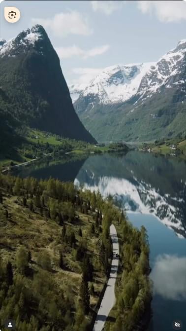
Can anyone help me find the road number that is shown in this photo? I think it is Geirangerfjord but not sure. Other half really wants to drive it in an upcoming trip. I have tried everything from Google Lens to Google Street View and can’t find it. Any help would be appreciated.
https://i.redd.it/6cah0dp4zv3f1.jpeg
Posted by RavenJoolz
6 Comments
My guess is somewhere along this route: [https://www.nasjonaleturistveger.no/en/routes/geiranger–trollstigen/ornesvingen/](https://www.nasjonaleturistveger.no/en/routes/geiranger–trollstigen/ornesvingen/)
If you want to know for sure I guess you can go to street view on google maps and follow it, to see if you find the exact spot from your photo
Where’s the pic from? As in: where did you find the pic?
Definitely not Geiranger. Most likely a fresh water lake we’re seeing
It could be fresh water.
This looks like a picture from a drone, and street view will not look like this.
Try 15 by oppstrynsvatnet, or forget about this. There is too much that looks like this.
You are lucky, I believe I was there last week. I think it is Fylkesvei 5724 by Olden driving southward. You can search for “Sunde Panorama” on google maps.
But it should be around here if you want to check street view: https://maps.app.goo.gl/nXXzeEUwQRqdwQa49?g_st=com.google.maps.preview.copy
This is in Oldedalen, Fv724.
https://maps.app.goo.gl/tjgUVNKZToL84seh6