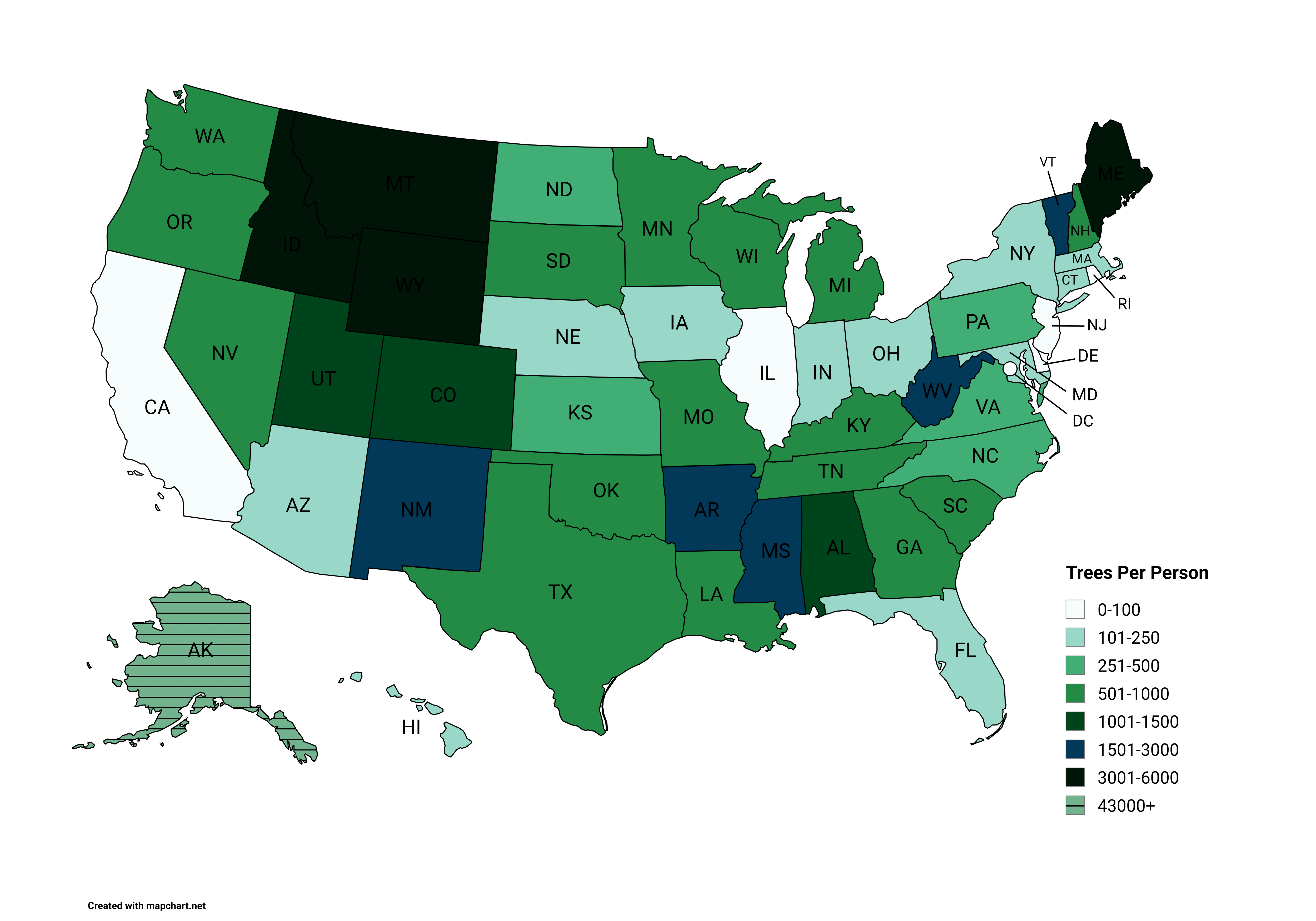
california has way too much people, i dont think illinois and nj and dc have a whole lot of natural trees at all plus big population.
rustyfinna on
Good example of how the low population of Wyoming can really skew stats-
We don’t have many trees here, lots and lots of grasslands, but per person sure makes you think we have lot of trees!
Keep that in mind for other maps
Naive_Inspection7723 on
Fake, Northern California is all trees,
Xrsyz on
Bullshit. Look at Florida on a satellite map. Mangroves are trees. Makeleucas are trees. And palm trees are trees.
gggg500 on
Huh. I would think West Virginia would be much higher since it has a low population and is mostly covered thick mountainous forests.
Quick math: 600 trees per acre (Google search) * 640 acres per square mile * 24,041.2 West Virginia land area /1,769,979 West Virginia population in 2024 = 5,215.77 trees per person. This does not match the color code for the map.
(Wooded forests can have between 200-1,000 trees per acre). West Virginia is very mountainous, but much of its forests are very thick due to inability to build farms, roads, houses, or even easily log for timber. So yes the elevation could play a factor in reducing the number of trees per acre, but this would be offset by the fact that it has very limited human footprint/development.
It makes me fall into question the accuracy of this map. It’s a cool concept for a map, but the data seems off to me.
jnpitcher on
I lived in Illinois for two years and remember missing forests. I’d drive for miles on the highway without seeing any trees – just corn fields to the horizon in every direction.
sirbruce on
The numbers on this map seem low to me.
BOGDOGMAX on
North Dakota 1.72% forest cover
New Jersey 41.72% forest cover
AgeOfReasonEnds31120 on
People live in cities.
frame_3_1_3 on
Who counted these trees?
Specific-Mix7107 on
Thought this was trans persons by state at first and was so surprised haha
timshel_turtle on
Illinois has a National Forest in it. Does that not even out Chicago being such a big city some?
Ytmedxdr on
Someone has New Hampshire miscounted. It’s 83% covered in trees with only 1.4 million people. Yes, it’s small, but it shouldn’t be colored that far different from nextdoor Vermont.
whoopercheesie on
Il is mostly farmland
SufficientBowler2722 on
As an introvert who loves nature this validates my strange attraction to Montana and Idaho
TwentySevenSeconds on
I don’t think I’ve ever seen a natural tree in all of Nevada. TIL!
toe_knee on
The shift from green hues to blue is killing me.
treetopalarmist_1 on
Yeah and some jerk is saying cut baby cut.
Workingclassherois on
Not true for Kansas.
I drove all the way across Kansas. I saw two trees. One was dead from loneliness and wind damage and the other had just arrived, seeking asylum from logging camps in Louisiana, and wishing it had stopped in Arkansas.
JamCom on
Every state must be blue
Igor_InSpectatorMode on
My home of New Mexico having more trees per capita than Colorado, even after our massive wildfires, makes me happy. So many people think we are just a flat desert and have no idea how many mountains New Mexico has or how wooded they are. Colorado only has 1.5 times as many people as New Mexico too. Still definitely skewed by a per capita measure though.
PangolinWorldly6963 on
Hey look, a perfect best place/worse place to live map -signed, an Alaskan
Throwaway-8589 on
I’m vacationing in Alaska right now and that statistic is not surprising at all. Especially when you consider how sparsely populated it is and just how many trees there are on the panhandle alone.


23 Comments
california has way too much people, i dont think illinois and nj and dc have a whole lot of natural trees at all plus big population.
Good example of how the low population of Wyoming can really skew stats-
We don’t have many trees here, lots and lots of grasslands, but per person sure makes you think we have lot of trees!
Keep that in mind for other maps
Fake, Northern California is all trees,
Bullshit. Look at Florida on a satellite map. Mangroves are trees. Makeleucas are trees. And palm trees are trees.
Huh. I would think West Virginia would be much higher since it has a low population and is mostly covered thick mountainous forests.
Quick math: 600 trees per acre (Google search) * 640 acres per square mile * 24,041.2 West Virginia land area /1,769,979 West Virginia population in 2024 = 5,215.77 trees per person. This does not match the color code for the map.
(Wooded forests can have between 200-1,000 trees per acre). West Virginia is very mountainous, but much of its forests are very thick due to inability to build farms, roads, houses, or even easily log for timber. So yes the elevation could play a factor in reducing the number of trees per acre, but this would be offset by the fact that it has very limited human footprint/development.
It makes me fall into question the accuracy of this map. It’s a cool concept for a map, but the data seems off to me.
I lived in Illinois for two years and remember missing forests. I’d drive for miles on the highway without seeing any trees – just corn fields to the horizon in every direction.
The numbers on this map seem low to me.
North Dakota 1.72% forest cover
New Jersey 41.72% forest cover
People live in cities.
Who counted these trees?
Thought this was trans persons by state at first and was so surprised haha
Illinois has a National Forest in it. Does that not even out Chicago being such a big city some?
Someone has New Hampshire miscounted. It’s 83% covered in trees with only 1.4 million people. Yes, it’s small, but it shouldn’t be colored that far different from nextdoor Vermont.
Il is mostly farmland
As an introvert who loves nature this validates my strange attraction to Montana and Idaho
I don’t think I’ve ever seen a natural tree in all of Nevada. TIL!
The shift from green hues to blue is killing me.
Yeah and some jerk is saying cut baby cut.
Not true for Kansas.
I drove all the way across Kansas. I saw two trees. One was dead from loneliness and wind damage and the other had just arrived, seeking asylum from logging camps in Louisiana, and wishing it had stopped in Arkansas.
Every state must be blue
My home of New Mexico having more trees per capita than Colorado, even after our massive wildfires, makes me happy. So many people think we are just a flat desert and have no idea how many mountains New Mexico has or how wooded they are. Colorado only has 1.5 times as many people as New Mexico too. Still definitely skewed by a per capita measure though.
Hey look, a perfect best place/worse place to live map -signed, an Alaskan
I’m vacationing in Alaska right now and that statistic is not surprising at all. Especially when you consider how sparsely populated it is and just how many trees there are on the panhandle alone.