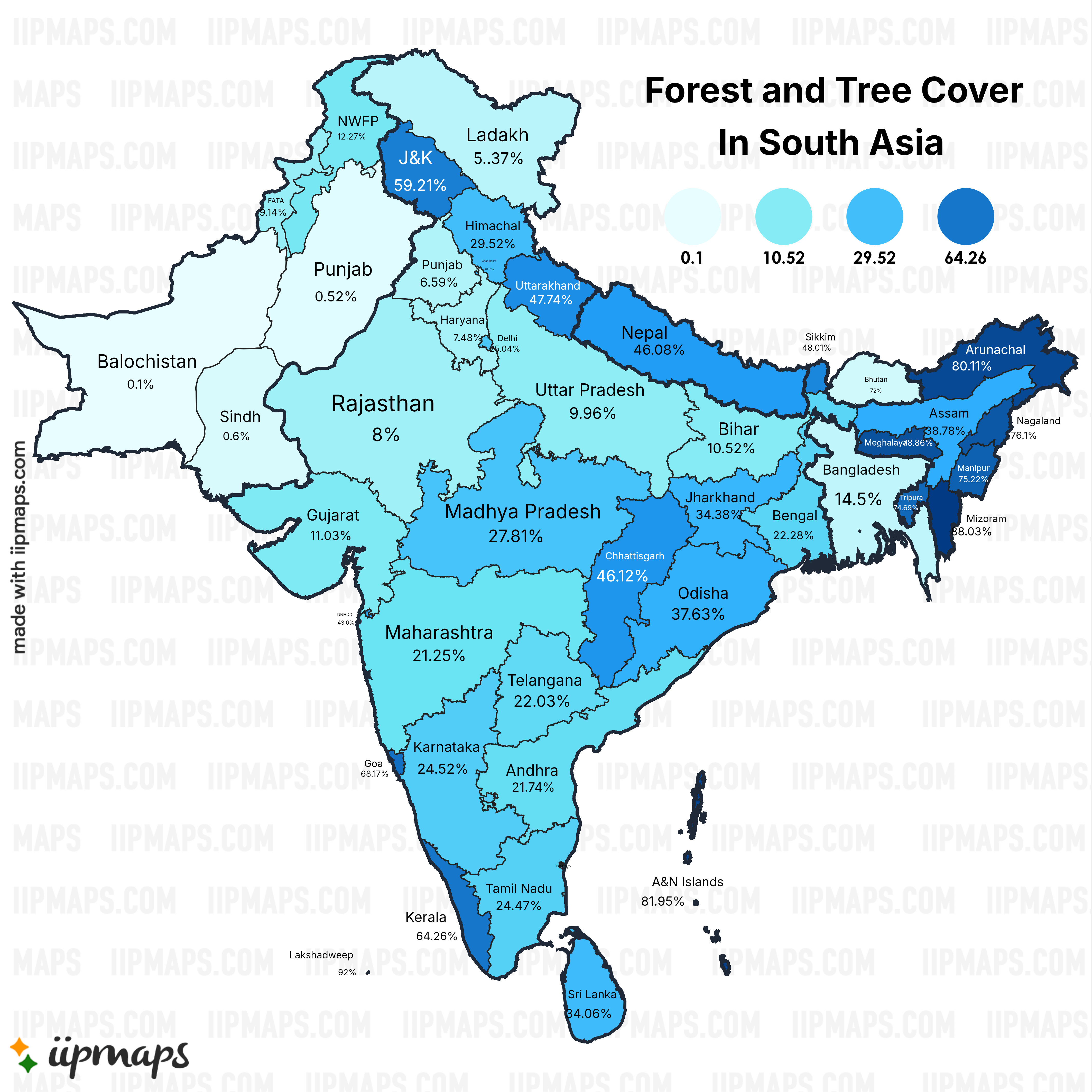
Damn, the difference between Pakistani and Indian Punjab is insane, especially if you include Himachal and Haryana (previously parts of Punjab).
ihavenoyukata on
Wtf is UP doing? Did they just delete forests for agricultural use?
Dios94 on
How is Kerala so high, being the third densest state in India?
946stockton on
Google street view a random spot in India and you’ll see either trash, dirt or a pile of rubble/rocks, or all three.
reedspacer38 on
Bhutan is mis-colored and Ladakh’s percentage has an extra punctuation mark in it
WitELeoparD on
I like that this map was clearly made by an Indian Nationalist since ‘Ladakh’ contains the entirety of Gilgit Baltistan which was controlled by India for what mere weeks before the local Gilgit Scouts under their British commander rebelled and overthrew the government.
It also means the data is wrong, since the authority that surveyed Ladakh never had access to Gilgit so the percentage probably doesn’t accurately represent the region.
Also this map must be at least a decade old since the province of KPK is divided and called NWFP, which changed in 2010.

![[OC] Forest and Tree Cover in South Asia](https://www.byteseu.com/wp-content/uploads/2025/07/dxgxvp2lqoef1-1536x1536.png "[OC] Forest and Tree Cover in South Asia")
6 Comments
Damn, the difference between Pakistani and Indian Punjab is insane, especially if you include Himachal and Haryana (previously parts of Punjab).
Wtf is UP doing? Did they just delete forests for agricultural use?
How is Kerala so high, being the third densest state in India?
Google street view a random spot in India and you’ll see either trash, dirt or a pile of rubble/rocks, or all three.
Bhutan is mis-colored and Ladakh’s percentage has an extra punctuation mark in it
I like that this map was clearly made by an Indian Nationalist since ‘Ladakh’ contains the entirety of Gilgit Baltistan which was controlled by India for what mere weeks before the local Gilgit Scouts under their British commander rebelled and overthrew the government.
It also means the data is wrong, since the authority that surveyed Ladakh never had access to Gilgit so the percentage probably doesn’t accurately represent the region.
Also this map must be at least a decade old since the province of KPK is divided and called NWFP, which changed in 2010.