

02:22 BST
As Donald Trump has just alluded to the possibility of “swapping of territories” between Kyiv and Moscow, let’s take a look at the different stages of Russia’s invasion of Ukraine.
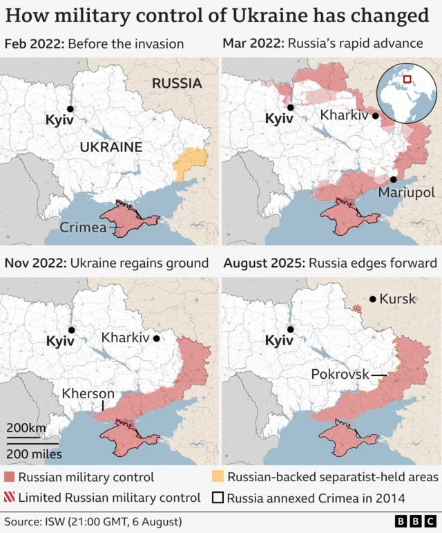
Russia’s full-scale invasion began with dozens of missile strikes on cities all over Ukraine before dawn on 24 February 2022. Its ground troops moved in quickly and, within a few weeks, controlled large areas of Ukraine, advancing to the suburbs of Kyiv and bombarding Kharkiv.
Russian forces had taken territory in the east and south as far as Kherson, and surrounded the port city of Mariupol.
But they met strong Ukrainian resistance almost everywhere and faced serious logistical problems with poorly motivated Russian troops suffering shortages of food, water and ammunition.
By October 2022, the picture had changed dramatically and, having failed to take Kyiv, Russia withdrew completely from the north. The following month, Ukrainian forces recaptured the southern city of Kherson.
Since then, the battle has mostly been in the east of Ukraine with Russian forces slowly gaining ground over many months. In 2024, Ukrainian forces captured parts of Russia’s Kursk region, but has since been pushed back.