Generated in MATLAB by sampling 1,000,000 random points from within US states shapefiles (https://www2.census.gov/geo/tiger/GENZ2018/shp/cb_2018_us_state_500k.zip) then calculating the great-circle distances to every city in the US Cities Database from simplemaps (https://simplemaps.com/data/us-cities). The value shown is the minimum distance, in miles, from each sampled point to any town with more than 1,000 people within the 48 contiguous United States.
FwompusStompus on
Cool, but i hate the colors you chose.
FightOnForUsc on
can we get Alaska and Hawaii?
H_Lunulata on
This map doesn’t include Canada, which is not a whiny Canada comment so much as “It grossly changes some of the yellow parts, like on the slanty bit of Maine because there are plenty of towns over 1000 people on the Canadian side of the border, like Saint Georges, QC (population 32000ish) which is 20 miles from the border right about where the yellow/white spot is on the slanty part of Maine.
You can’t really say you’re remote if you’re within a bike ride from a city of 30k people.
lnsybrd on
1,000 people is a pretty low number to choose. What made you pick that?
__Quercus__ on
Either the title needs to change to closest US city, or Maine needs to be redone to reflect cities of over 1000 people just over the border in Quebec. For example, Saint-Prosper, Quebec, with a population of 3,600, is about 10 miles from the Maine border that that’s shown as nearly 100 miles from the nearest town.
DancingPhantoms on
Im thinking if you chose 5000 or 10000 as your cut off point, this map would be mostly yellow/white.
Isaac_Ostlund on
Can you do it but for cities of 2500, or 5000?
txa1265 on
I feel like a log scale would pop out the distinctions much better … as well as a color scale that looked less like a marshmallow toasted into oblivion.
marcduberge on
northern Nevada looks very different for about a week per year
collin3000 on
I’ve driven through a lot of these places as a traveling entertainer, not famous enough to be working great gigs. Some of them truly are just barren.
There’s one stretch in Nevada you can clearly see on the map that is the most desolate. It has a sign saying no gas for like 130+ miles right before a gas station that’s of course 50% above normal price. I’ve usually found those signs to be lies (it’ll be half that distance), i hadn’t driven it before, and my car said 178 miles estimated range so I kept driving.
It turns out that’s the one sign that’s accurate, and it’s distance is mostly through mountains. There were points where I literally didn’t see another car for 10 minutes. So to make sure I’d make it I had to start using every driving hypermiling technique I know down to eventually, even unplugging my phone charger. Because there was no cell service and it would probably take me half a day hitchhike to the nearest gas station and back with the low traffic.
I coasted down the last mountain in neutral to barely roll into the first gas station I saw as it clicked to zero estimated miles remaining.
I can’t imagine being one of the (literally) few people that wants to live there unless you want to bury a lot of bodies that no one will ever find.
CaptainColdSteele on
Kinda makes me want to move to Nevada
PronunciationIsKey on
Is this the opposite of r/peopleliveincities?
spidereater on
I’ve been to northern New England and it felt pretty empty. I didn’t realize it was so much more remote than Nevada or Arizona or Texas.
Phil517 on
Didn’t realize how remote western Maine was. I’ve been to Maine numerous times but not that part.
percydaman on
Wild west still wild I guess.
LnStrngr on
I would have expected a line going up from New Orleans along the Mississippi.
chiqu3n on
Useless map, try with 10,000 people town
0xCUBE on
A lot of people don’t realize just how rural internal Maine is. If you look at a map of the towns, you’ll notice that a lot of the ones up north are just rectangles with numbers attached to them, as many don’t have anyone living there. It’s quite eerie.
NewChinaHand on
What is it with people posting maps of the United States missing two of the 50 states
LiamTheHuman on
This would be really cool as a video that transitions the number of people required in the closest town up to the size of some of the largest cities.
dohzer on
Crazy that some people live “100” away from towns.
AvariceLegion on
This changing over time would be interesting to see
lucianw on
I love this map! What an inventive idea!
Zagrunty on
1000 is an insanely low number. I’d be more interested at over 10k. Or multiple maps also showing 50k and 100k
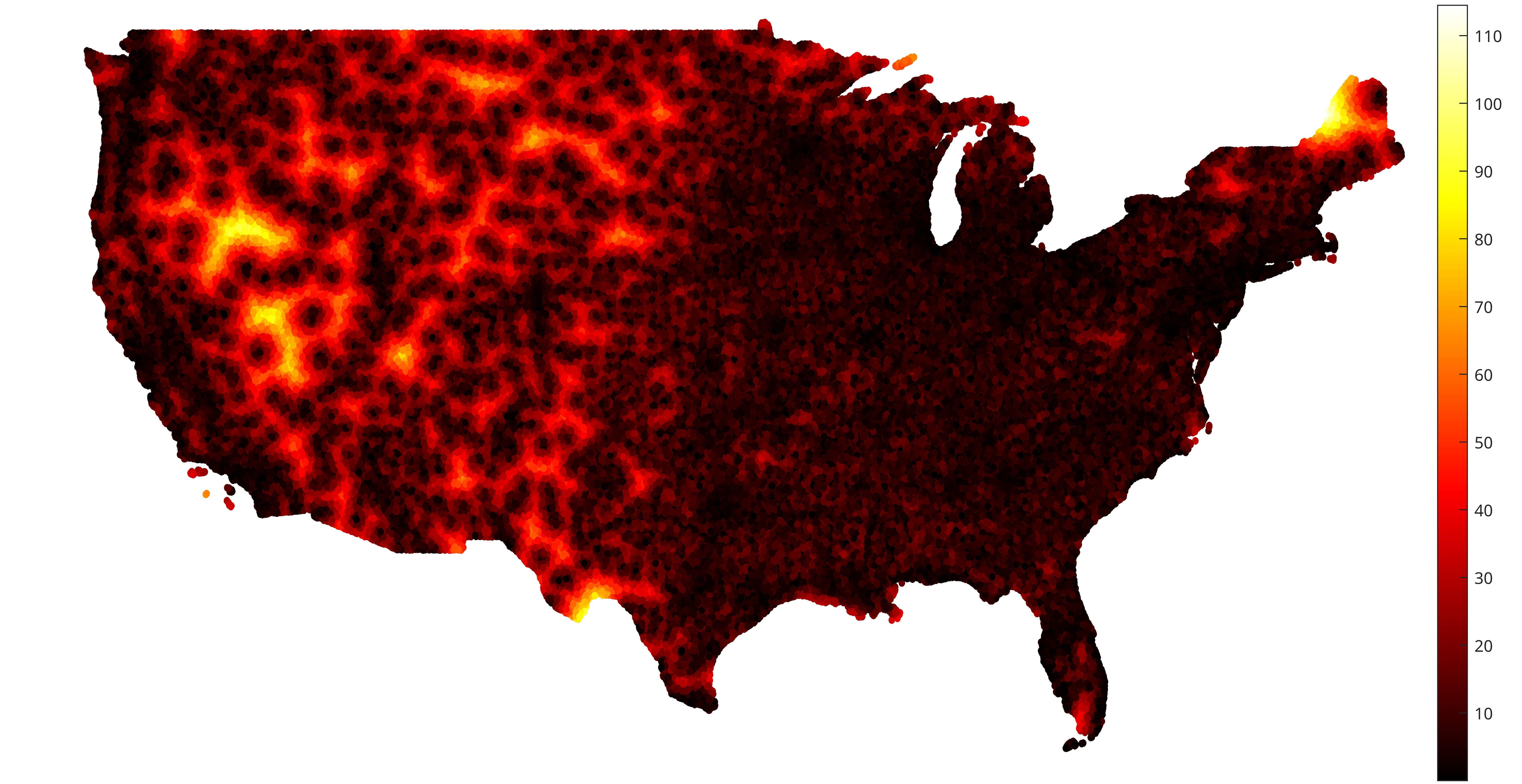

![[OC] Remoteness: distance in miles to the nearest town with more than 1,000 people](https://www.byteseu.com/wp-content/uploads/2025/09/ioxkakrnwypf1-1536x791.jpeg "[OC] Remoteness: distance in miles to the nearest town with more than 1,000 people")
25 Comments
Generated in MATLAB by sampling 1,000,000 random points from within US states shapefiles (https://www2.census.gov/geo/tiger/GENZ2018/shp/cb_2018_us_state_500k.zip) then calculating the great-circle distances to every city in the US Cities Database from simplemaps (https://simplemaps.com/data/us-cities). The value shown is the minimum distance, in miles, from each sampled point to any town with more than 1,000 people within the 48 contiguous United States.
Cool, but i hate the colors you chose.
can we get Alaska and Hawaii?
This map doesn’t include Canada, which is not a whiny Canada comment so much as “It grossly changes some of the yellow parts, like on the slanty bit of Maine because there are plenty of towns over 1000 people on the Canadian side of the border, like Saint Georges, QC (population 32000ish) which is 20 miles from the border right about where the yellow/white spot is on the slanty part of Maine.
You can’t really say you’re remote if you’re within a bike ride from a city of 30k people.
1,000 people is a pretty low number to choose. What made you pick that?
Either the title needs to change to closest US city, or Maine needs to be redone to reflect cities of over 1000 people just over the border in Quebec. For example, Saint-Prosper, Quebec, with a population of 3,600, is about 10 miles from the Maine border that that’s shown as nearly 100 miles from the nearest town.
Im thinking if you chose 5000 or 10000 as your cut off point, this map would be mostly yellow/white.
Can you do it but for cities of 2500, or 5000?
I feel like a log scale would pop out the distinctions much better … as well as a color scale that looked less like a marshmallow toasted into oblivion.
northern Nevada looks very different for about a week per year
I’ve driven through a lot of these places as a traveling entertainer, not famous enough to be working great gigs. Some of them truly are just barren.
There’s one stretch in Nevada you can clearly see on the map that is the most desolate. It has a sign saying no gas for like 130+ miles right before a gas station that’s of course 50% above normal price. I’ve usually found those signs to be lies (it’ll be half that distance), i hadn’t driven it before, and my car said 178 miles estimated range so I kept driving.
It turns out that’s the one sign that’s accurate, and it’s distance is mostly through mountains. There were points where I literally didn’t see another car for 10 minutes. So to make sure I’d make it I had to start using every driving hypermiling technique I know down to eventually, even unplugging my phone charger. Because there was no cell service and it would probably take me half a day hitchhike to the nearest gas station and back with the low traffic.
I coasted down the last mountain in neutral to barely roll into the first gas station I saw as it clicked to zero estimated miles remaining.
I can’t imagine being one of the (literally) few people that wants to live there unless you want to bury a lot of bodies that no one will ever find.
Kinda makes me want to move to Nevada
Is this the opposite of r/peopleliveincities?
I’ve been to northern New England and it felt pretty empty. I didn’t realize it was so much more remote than Nevada or Arizona or Texas.
Didn’t realize how remote western Maine was. I’ve been to Maine numerous times but not that part.
Wild west still wild I guess.
I would have expected a line going up from New Orleans along the Mississippi.
Useless map, try with 10,000 people town
A lot of people don’t realize just how rural internal Maine is. If you look at a map of the towns, you’ll notice that a lot of the ones up north are just rectangles with numbers attached to them, as many don’t have anyone living there. It’s quite eerie.
What is it with people posting maps of the United States missing two of the 50 states
This would be really cool as a video that transitions the number of people required in the closest town up to the size of some of the largest cities.
Crazy that some people live “100” away from towns.
This changing over time would be interesting to see
I love this map! What an inventive idea!
1000 is an insanely low number. I’d be more interested at over 10k. Or multiple maps also showing 50k and 100k