
October 27, 2025
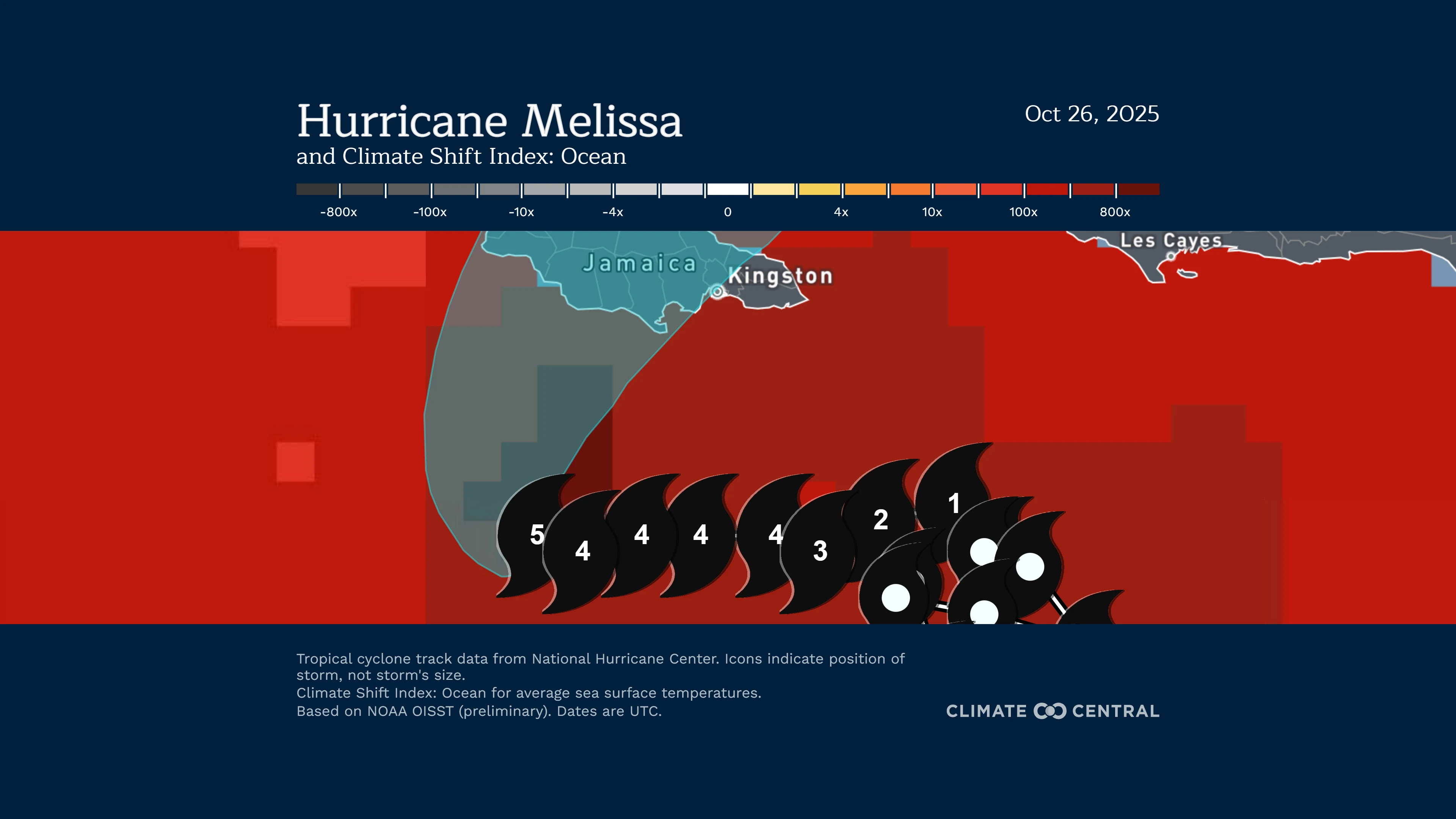
Hurricane Melissa reached Category 4 strength, with winds of 140 mph, between Oct. 25 and 26 after undergoing extreme rapid intensification — an increase of about 70 mph in just 24 hours. The storm further strengthened into a Category 5 hurricane on October 27.
Melissa’s rapid strengthening occurred as it drifted slowly over exceptionally warm ocean waters that were 2.5°F (1.4°C) warmer than average — these conditions were made up to 700 times more likely because of human-caused climate change.
These unusually warm ocean temperatures, combined with overall tropical climate warming, are projected to have strengthened Melissa’s top wind speed by about 10 mph — pushing it to become a Category 5 storm, and increasing its potential damages by up to 50%. Without human-caused climate change, Melissa likely would have been a Category 4 storm at its peak.
For further updates and the latest up-to-date information about how climate change may impact this storm, visit “Hurricane Melissa and climate change”.
Note: This is NOT a storm forecast. Visit the National Hurricane Center for the latest updates and information on how the storm is evolving.
According to the National Hurricane Center, the storm’s slow movement and intensity of this system will create a “multi-day period of damaging winds and heavy rainfall… causing catastrophic flash flooding, numerous landslides, extensive infrastructural damage, long-duration power and communication outages, and potentially prolonged isolation of communities.”
How is climate change influencing this storm?
-
In the Central Caribbean, sea surface temperatures (SSTs) are 1.4°C (2.5°F) above average for mid-to-late October, providing extra heat energy that is fueling Melissa’s strength. These exceptionally warm sea surface temperatures along Melissa’s path are at least 500 to 800 times more likely due to human-caused climate change.
-
Up to 20–30 inches of rain are forecast across much of Jamaica as Melissa approaches and passes the island.
-
Warmer oceans from human-caused climate change are contributing to hurricanes that produce heavier rainfall and greater flooding impacts at landfall.
-
Tropical cyclone rainfall rates are increasing by more than 1% per year, increasing the risk of inland flooding, as storms hold more moisture and maintain their strength longer over land.
-
Tropical cyclone rainfall rates have increased in the Atlantic, with further increases expected as warming continues.
-
What do experts say?
Dr. Daniel Gilford, Meteorologist and Climate Scientist at Climate Central, said:
“Human-caused climate warming is making all of Melissa’s dangers worse: driving heavier rainfall, more damaging wind speeds, and higher storm surge along the coast. Climate-boosted ocean heat helped push Melissa to Category 5 strength, increasing its potential damages by as much as 50%.”
How do we know climate change is influencing this heat?
The Climate Shift Index: Tropical Cyclones (Tropical Cyclone CSI) is grounded in peer-reviewed methodology and high-quality data. It quantifies the impact of human-caused climate change on a storm’s intensity.
The Tropical Cyclone CSI calculates the increase (or decrease) in a storm’s wind speeds because of climate change-warmed ocean waters and tropical climate warming.
This system is built on the foundation of our Climate Shift Index: Ocean (Ocean CSI) tool, which shows daily sea surface temperatures across the globe and quantifies how human-caused climate change has increased (or decreased) the likelihood of those temperatures.
To request an interview with a Climate Central scientist, please contact Abbie Veitch at aveitch@climatecentral.com.