
![[OC] 🏔️Can you really trust your smart watch or GPS tracking app to measure elevation?](https://www.byteseu.com/wp-content/uploads/2025/11/47ytf92kwr1g1-1536x782.png "[OC] 🏔️Can you really trust your smart watch or GPS tracking app to measure elevation?")
TL;DR don’t trust raw GPS elevation gain on smart watches and GPS-based tracking apps. Post-processing often makes it worse. Smoothing helps but can erase real peaks. A hybrid approach (or just using live tracking) gives the most realistic numbers.
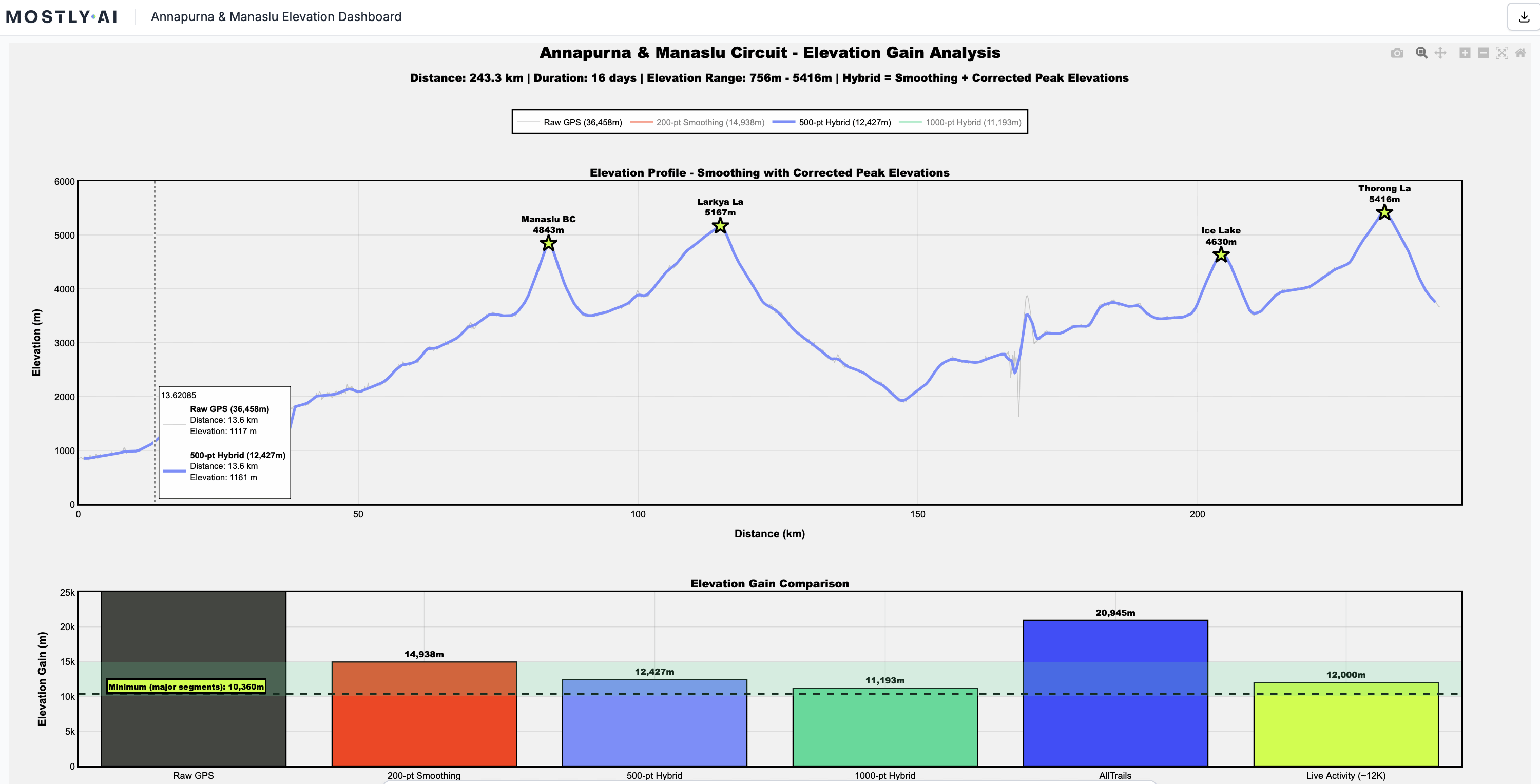
Made with MOSTLY AI. Check out the chart and interrogate the data yourself.
I just finished the Manaslu–Annapurna Circuit in Nepal (243 km, 16 days, two 5,000m+ passes) and found something wild: most GPS apps massively misreport elevation gain. AllTrails showed ~12,000m gain during the trek, but when I exported and combined the GPX files afterward, it suddenly jumped to 20,945m. My own manual calculation of the major climbs gave a minimum of 10,360m. Same app, same data, 75% difference.
So I dug into all 64,982 GPS trackpoints to figure out what was going on. The raw data claimed 36,458m of elevation gain (totally wrong, pure noise). A simple 2m threshold still gave 16,097m. Heavy smoothing (1000-point rolling average) produced 10,685m, which was closer but shaved 50–250m off actual high passes.
The problem is that GPS elevation is insanely noisy: 65.7% of my elevation changes were less than 1 meter, just jitter that artificially stacks up into thousands of meters of fake “gain.”
I built a hybrid smoothing + peak-correction method that preserves real summits while filtering noise, and got 12,427m, which matches the Live Activity tracking almost perfectly.
Pretty wild findings tbh.
Posted by SyllabubNo626
9 Comments
What exactly did you use for recording? What device, which Satellite networks?
It’s not that elevation from GPS is wrong, it just includes noise and you are summing up all that noise. A sort of like the coastline paradox.
I wear a watch with a barometric altimeter while flying small, unpressurized planes. Every time I’ve compared the data after a flight it’s been accurate to within 50ft. While it’s not perfect, if my plane’s altimeter failed during a flight I’m confident it would work well enough to land safely.
What’s the ground truth of the elevation gain on that route? Presumably someone’s measured it with a more accurate device?
The height measurement is highly (hehe) dependent on the accuracy of the measurement oft your position. The more satellites signals you receive and the more free the horizon sight is, the better is the result. But the height of any GPS signal (Navstar*, Galieleo, GLONASS, …) is way worse than your horzontal posititon. And even the horizontal position deviates arount 5-10 metres.
*Navstar is the name for the American GPS.
well you have to smooth somewhat otherwise every little error or rela world bump is ognna count as elevation covered
thats regardless of waht method you use to measure altitude
GPS vertical accuracy is much worse than horizontal, this is why “proper” outdoor tracking devices use a barometric pressure sensor for altitude measurement, and GPS is only used to calibrate it with a lot of averaging and using DEM maps.
This problem has been known since the creation of GPS. I invite you to search for ‘Digital Elevation Model’.
To put it simply, GPS satellites move at a fixed altitude relative to the Earth’s centre of gravity. They move on the surface of a perfect sphere. Except that the Earth is not a perfect sphere, it is an ellipsoid flattened at the poles and it is irregular.
There are many models that allow for the correspondence of coordinates, but they are all quite inaccurate in defining the average sea level (altitude 0).
Due to many technical limitations, altitude estimation has always been very poor with a purely GPS system. With a good modern device, we can get an estimate of +/- 50m, but with the first hiking GPS devices, the data was hidden because it was so poor and could be dangerously misleading.
By way of comparison, a barometric altimeter calibrated at a reference point has an error of +/- 10m, even with significant weather variations.
This is why either the device has a barometric altimeter and calibrates itself automatically using a DEM map and GPS coordinates, or the altitude data is not used and the altitude is recalculated from the DEM during export. This is particularly noticeable when crossing a bridge and the altitude tracker considers that you have passed through the bottom of the valley or canyon.
So either your GPS device has high noise or low resolution and smooths the altitude measurement considerably to avoid displaying an absurd total elevation gain, or its internal DEM model and elevation map have fairly low resolution and it interpolates a lot between points with known altitudes.
TL;DR: GPS devices are useless for determining altitude; barometric altimeters are good, but the most reliable instrument is an elevation chart.
GPS has a radius of confusion, this would naturally be a sphere, but as people mainly use it to find their horizontal position, the horizontal diameter is reduced at the expense of a larger vertical error bar.
So the sphere of confusion turns into a vertical cigar of confusion.