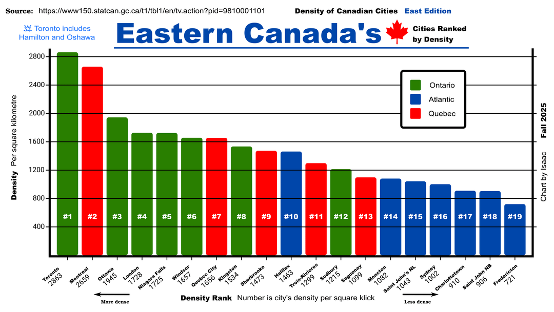
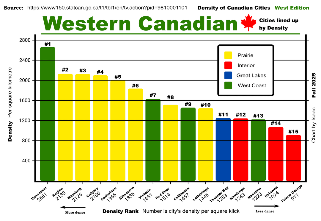
Info is from Statistics Canada and the charts are made in Krita
cre8ivjay on
I wonder if it’s CMA based or city proper.
Vancouver proper is incredibly dense, but places like Surrey would be lower.
Calgary, while still doing better than many on this list is mostly one city with all kinds of density – higher and lower – throughout.
InternationalReserve on
Whatever way they’ve defined “Ottawa” is must not include some of the amalgamated areas for some reason, because otherwise there’s no way the population density is that high. Looking through the data-set it seems like they do indeed count Kanata seperately
nemom on
What’s the definition of “Eastern” and “Western” Thunder Bay is in Ottawa, which is on the Eastern chart.
postwhateverness on
How is Vancouver more dense than Montreal? Which parts of the cities are being included?
simplepimple2025 on
Where did KW-Cambridge go? It’s way bigger than some other cities here.
BigMrTea on
As an Ottawan I’m used to being called dense
uncoolcentral on
The grouping/taxonomy is whack. E.g. Thunder Bay is great “Great Lakes” but Toronto isn’t?
¯\_(ツ)_/¯
Hyack57 on
Do Airdrie Alberta. Holy geez.
2,227. So more than Calgary?
roccerfeller on
The prairie cities being dense surprises me they’re pretty spread out
kksweetz on
Is Regina and Winnipeg really more dense than Calgary? I feel the suburbs of larger downtowns are really fucking this up
mushnu on
Visiting Victoria from Quebec City, I can see now why I felt like it was just about the right size
Krjax on
Small thing, but a little issue in Title consistency.
Eastern Canada’s…
Western Canadian…
drillbitpdx on
* What is the value of separating Eastern and Western Canada? The distributions don’t look any different.
* Where exactly are you drawing the line between Eastern and Western? Thunder Bay, ON is in the “west edition”, while all other Ontario cities are in the “east edition.”
* Why does Toronto include Hamilton and Oshawa, while other cities apparently *don’t* include their suburbs? This’ll completely skew the data.
* Why use the non-standard jargon term “square klick” rather “square kilometre”?
MyPopeSmokesDope on
Y axis is measured in square kilometres, and the x axis is in density rank as measured in square klicks. I don’t know if anyone other than Canadians would recognize klicks as slang for kilometre?
Dudegamer010901 on
Very shocked that Regina is the 2nd densest in Western Canada
MaLLahoFF on
Something is weird with these stats.
Kamloops is absolutely not this dense. The citation only accounts for 70Km^2, but Kamloops has closer to 300^km of space.
They’re likely only measuring the “City Center” and not the “Metropolitan Area”.
But here, that’s like 20,000 people. 15-20% of us live in the wider area, so describing it this densely, doesn’t really capture the feeling of the space. Which is what I assume this graph is for.
Data is fun.
unimatrix_0 on
is this mass-density? Energy-density? Car density? Papal density?

![[OC] Density of Canadian Cities East and West](https://www.byteseu.com/wp-content/uploads/2025/11/mbziqf6a222g1-1024x577.png "[OC] Density of Canadian Cities East and West")
19 Comments
Including Hamilton and Oshawa is skewing the graph. Toronto feels way more dense than Montreal.
Source: [https://www150.statcan.gc.ca/t1/tbl1/en/tv.action?pid=9810001101](https://www150.statcan.gc.ca/t1/tbl1/en/tv.action?pid=9810001101)
Info is from Statistics Canada and the charts are made in Krita
I wonder if it’s CMA based or city proper.
Vancouver proper is incredibly dense, but places like Surrey would be lower.
Calgary, while still doing better than many on this list is mostly one city with all kinds of density – higher and lower – throughout.
Whatever way they’ve defined “Ottawa” is must not include some of the amalgamated areas for some reason, because otherwise there’s no way the population density is that high. Looking through the data-set it seems like they do indeed count Kanata seperately
What’s the definition of “Eastern” and “Western” Thunder Bay is in Ottawa, which is on the Eastern chart.
How is Vancouver more dense than Montreal? Which parts of the cities are being included?
Where did KW-Cambridge go? It’s way bigger than some other cities here.
As an Ottawan I’m used to being called dense
The grouping/taxonomy is whack. E.g. Thunder Bay is great “Great Lakes” but Toronto isn’t?
¯\_(ツ)_/¯
Do Airdrie Alberta. Holy geez.
2,227. So more than Calgary?
The prairie cities being dense surprises me they’re pretty spread out
Is Regina and Winnipeg really more dense than Calgary? I feel the suburbs of larger downtowns are really fucking this up
Visiting Victoria from Quebec City, I can see now why I felt like it was just about the right size
Small thing, but a little issue in Title consistency.
Eastern Canada’s…
Western Canadian…
* What is the value of separating Eastern and Western Canada? The distributions don’t look any different.
* Where exactly are you drawing the line between Eastern and Western? Thunder Bay, ON is in the “west edition”, while all other Ontario cities are in the “east edition.”
* Why does Toronto include Hamilton and Oshawa, while other cities apparently *don’t* include their suburbs? This’ll completely skew the data.
* Why use the non-standard jargon term “square klick” rather “square kilometre”?
Y axis is measured in square kilometres, and the x axis is in density rank as measured in square klicks. I don’t know if anyone other than Canadians would recognize klicks as slang for kilometre?
Very shocked that Regina is the 2nd densest in Western Canada
Something is weird with these stats.
Kamloops is absolutely not this dense. The citation only accounts for 70Km^2, but Kamloops has closer to 300^km of space.
They’re likely only measuring the “City Center” and not the “Metropolitan Area”.
But here, that’s like 20,000 people. 15-20% of us live in the wider area, so describing it this densely, doesn’t really capture the feeling of the space. Which is what I assume this graph is for.
Data is fun.
is this mass-density? Energy-density? Car density? Papal density?