TIL that’s where Alaska and Hawaii are. Had no idea.
never_shit_ur_pants on
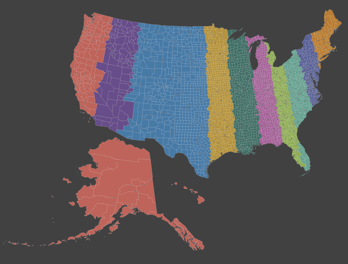
Everything except Florida is perfect here. I wish it were the official states
littlegipply on
Alaska be thiccc
doob22 on
Data?
TheChance on
Red accepts. We’ll take purple, too. See y’all around!
Sprocket_Scientist on
There’s a reason “mid coast” is another name for the Mississippi watershed.
Par_Lapides on
Trade off the teal in Florida for more of the upper section of green, just so we aren’t splitting peninsulas arbitrarily, and this is great. Every decistate has access to an ocean port and the full range of climate. As a Purplestater, I approve.
chezegrater on
I’ve only lived in three, but have been to nine. I’d tell you the color of the one I haven’t been to, but I can’t describe it other than puke green. Beautiful map.
satyrday12 on
Can OP please make a map of how these 10 states voted in 2024?
Norwester77 on
Trying to wrap my head around how a region anchored on Boise, Salt Lake, Phoenix, (EDIT: Las Vegas), San Bernardino, Orange County, and San Diego has as many people as one anchored on Anchorage, Seattle, Portland, San Francisco, LA, and Honolulu.
Hood_Harmacist on
Buffalo and Rochester shouldn’t be split up like that
JNSapakoh on
Wake up babe, new time zones dropped
Epicycler on
Genuinely curious whether this is accurate. I would expect that it would be more weighted toward the east, but I do see that several of the divisions run directly through major metropolitan areas (NYC, Chicago, DFW/OKC) so like… maybe?
Achilles-Foot on
i like this except for whats going on with florida
Big_Metal2470 on
Texas doing a lot of work in that blue section
heyitsmemaya on
**Orange County, CA approves being separate from LA County**
personthatssorandom on
I will name these zones.
From west to east, Los Angeles, Phoenix, Denver, Houston, Chicago, Atlanta, Jacksonville, Charlotte, Philadelphia, New York.
Aont no way red an purple have the same population, right??? Id guess that red would have 5× the population with the entirety of the west coast
Aztecah on
This doesn’t seem very correct
WhoIsYouIIsMeHuh on
There’s no way the lighter shade of purple and dark green are the same.
RadishPerson745 on
Purple can’t possibly be equal with red. Los Angeles alone has more people than most of the states in the purple area. Phoenix and San Diego can’t possibly be big enough to compensate.
Baked4skin on
Ohio and florida being in the same region, I’d avoid that part all together lol.
iamsy on
California has the population of like 20 states, this map is bunk


25 Comments
I refuse to accept this map, smh
TIL that’s where Alaska and Hawaii are. Had no idea.
Everything except Florida is perfect here. I wish it were the official states
Alaska be thiccc
Data?
Red accepts. We’ll take purple, too. See y’all around!
There’s a reason “mid coast” is another name for the Mississippi watershed.
Trade off the teal in Florida for more of the upper section of green, just so we aren’t splitting peninsulas arbitrarily, and this is great. Every decistate has access to an ocean port and the full range of climate. As a Purplestater, I approve.
I’ve only lived in three, but have been to nine. I’d tell you the color of the one I haven’t been to, but I can’t describe it other than puke green. Beautiful map.
Can OP please make a map of how these 10 states voted in 2024?
Trying to wrap my head around how a region anchored on Boise, Salt Lake, Phoenix, (EDIT: Las Vegas), San Bernardino, Orange County, and San Diego has as many people as one anchored on Anchorage, Seattle, Portland, San Francisco, LA, and Honolulu.
Buffalo and Rochester shouldn’t be split up like that
Wake up babe, new time zones dropped
Genuinely curious whether this is accurate. I would expect that it would be more weighted toward the east, but I do see that several of the divisions run directly through major metropolitan areas (NYC, Chicago, DFW/OKC) so like… maybe?
i like this except for whats going on with florida
Texas doing a lot of work in that blue section
**Orange County, CA approves being separate from LA County**
I will name these zones.
From west to east, Los Angeles, Phoenix, Denver, Houston, Chicago, Atlanta, Jacksonville, Charlotte, Philadelphia, New York.
It looks they got this from this website:
https://engaging-data.com/splitting-us-by-population/
It uses 2018 census data
Aont no way red an purple have the same population, right??? Id guess that red would have 5× the population with the entirety of the west coast
This doesn’t seem very correct
There’s no way the lighter shade of purple and dark green are the same.
Purple can’t possibly be equal with red. Los Angeles alone has more people than most of the states in the purple area. Phoenix and San Diego can’t possibly be big enough to compensate.
Ohio and florida being in the same region, I’d avoid that part all together lol.
California has the population of like 20 states, this map is bunk