

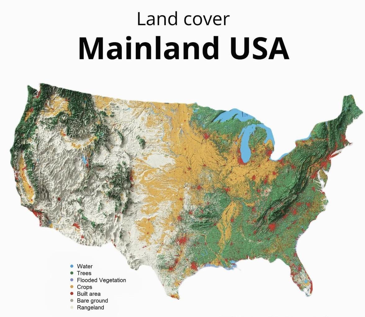
Mainland USA map reveals the hidden patterns that shape daily life: the ribbons of water, the vast forests that cradle the East, the endless crops of the Midwest, the rugged rangelands of the West, and the bright clusters of built areas growing across the country. Every color in this land cover map is a clue to how America breathes, grows, and transforms.
Posted by Radiant-Abroad-4683
21 Comments
Very cool map for demonstrating Atlanta’s strategic location at the southern terminus of the Appalachians.
“Bare ground” is extremely misleading
The area from Ohio all the way to Nebraska really just nothing but farmland?
That seems insane
As someone from the Albany, NY area It’s satisfying to see the sideways T shape of the Mohawk and Hudson so deeply defined with the city at the cross
Gonna be honest, there should be more farmland I think? Especially in the Northeast.
Beautiful
There a hires version of this?
really poor resolution. I can’t even make out Lake Tahoe.
Cool concept for a map, but some notable overlooks: they colored all that water on the East and West coasts wrong!
Despite everything going on in politics; I am truly grateful to live in the US. The geographical diversity and natural landscapes are truly breathtaking. I could spend the rest of my life driving all around the country and I’d never get bored. It really is America, the Beautiful.
Good representation of the topographical features in the country.
This country here has more miles of navigable inland waterways than the rest of the world combined.
So where is the rivers that run thru the crop areas. I dont see any rivers on the map
Dug around for the actual source and found a higher-res version as well:
– Creator: Milos Popovic/Milos Makes Maps ([Twitter](https://x.com/milosmakesmaps), [IG](https://www.instagram.com/milos_makes_maps/))
– Higher-res: [Twitter](https://x.com/milosmakesmaps/status/1989283980378861748?s=20), [direct](https://pbs.twimg.com/media/G5tbO_TX0AAwd7J?format=jpg&name=large)
Basically all of the areas labeled bare ground in the Intermountain West are not in fact bare.
I love being color blind
What’s the light green? Trees interspersed with … crops?
Interesting how the Everglades/Big Cypress are white and not grey
I am struck by the sheer size of the Detroit metropolis (which does not even include Windsor).
There is a high res version of this somewhere. I probably have it stored on an old phone or tablet, somewhere.
Props to whomever can post the higher res version for us.
What’s with all the light green? Is something missing from the legend or is it a mix of trees and crops that just look that way when combined in a lower resolution?