

MADISON, Wis. – With just a few days left of 2025, let’s take a look back at some of the notable weather, climate and space events that occurred across southern Wisconsin throughout the year.
January started off the year with a blast of Arctic air that sent high temperatures into the single digits and sent overnight lows well below zero. This blast of Arctic air began the night of January 18th and lasted through January 23rd.

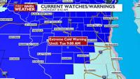
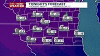
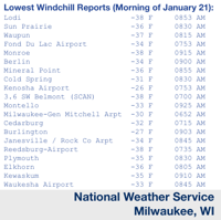
The coldest high temperature during this time was a mere 2 degrees on January 21st with overnight lows dipping between -10 and -15. Additionally, wind chill values were nearing -40 degrees waking up on January 21st.
While the cold temperatures may of made it feel like winter across southern Wisconsin, the strong high pressure systems that brought down and reinforced the cold air kept the snow away. Normally picking up just shy of 14″ of snow throughout January, the Madison area only picked up 1.9″. The lack of snow would help the drought conditions develop later in 2025. January 2025 would go on to be Wisconsin’s third driest on record.
February had not one but two snow storms move through southern Wisconsin within days of each other, which was then followed by a short blast of cold air.
The first snow storm moved through southern Wisconsin February 12th bringing several inches of snow, with some parts of southern Wisconsin picking up 6″ of snow or more. The next snow storm would arrive on February 14th.
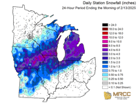
Heavier Snow fell across northern parts of Wisconsin with this latest snow storm; parts of Juneau, Adams, Sauk, Green Lake, Marquette and Waushara counties are estimated to have accumulated between 6-12″ of snow. Other parts of southern Wisconsin picked up between 2-4″. After this, two days of bitter cold as high temperatures dipped into the single digits.
Once again, Arctic air sent high temperatures into the single digits and overnight lows, particularly February 18th, well below zero. Temperatures would climb into the 50s by the following week.
In mid March, strong storms moved through southern Wisconsin and brought strong wind gusts to parts of the communities along the Wisconsin/Illinois border. Over 40 wind related reports were submitted across southern Wisconsin from those storms, with the top wind measuring 75 miles per hour in both Janesville and Edgerton.
maxuser
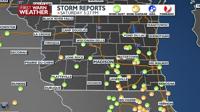
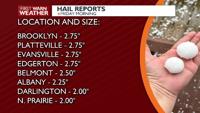
During the morning hours on April 18th, strong storms barreled through southern Wisconsin producing large hail. According to the National Weather Service Milwaukee reports the hail was some of the largest hail recorded since 2022.
A hail stone measuring 2.75″ was reported in Edgerton with a similarly sized hail stone being reported to have fallen in Attica in Green County. A 2.50″ hail stone fell in Albion in Dane County. The storms that produced these hail stones were the first storms to have a “destructive” damage tag with them issued by the National Weather Service Milwaukee.
maxuser
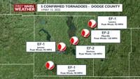
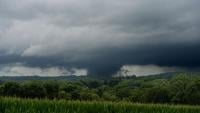
Despite a handful of tornadoes touching down earlier in the year across northern Wisconsin, southern Wisconsin would see its first round of tornadoes on May 15th.
A strong low pressure system began moving through the Midwest during the morning hours and by the late afternoon/early evening, a line of storms developed along the system’s warm front. While there was some embedded tornadoes within this line of storms, discrete thunderstorms ahead of this line also spawned a number of tornadoes.
One county that was hit particularly hard was Dodge County, where six tornadoes touched down on this day. Two EF-2 tornadoes moved through the county; one hitting Juneau and the other hitting Mayville. Two more tornadoes would touch down in Dodge County, in July, making their total tornado count 8. The most tornadoes to touch down in a single county in Wisconsin this year.
Jumping ahead to June, a few folks near Spring Green witnessed a tornado like weather phenomenon; cold air funnels. Unlike tornadoes which occur in warm, unstable air, cold air funnels occur under more stable air, sometimes in rain showers with cold air about a mile above the surface of the ground.
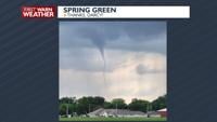
While they do look scary, cold air funnels rarely touch the ground. However, if they do, they can cause EF-0 damage.
In July another round of tornadoes touched down across southern Wisconsin; a total of five tornadoes touched down, two in Dodge County, one in Dane County, one in Juneau County and one in Iowa County.
Possible tornado near Lodi, July 16th, courtesy of Steve Meyer
The strongest rated tornado was an EF-1 tornado that moved through Iowa County, touching down near the intersection of Highway YZ and Z north of Dodgeville before lifting nearly 7 miles later near Knobs Road off of County Road H. Meteorologist Blaise Keller had to warn his mother to take shelter on air as this tornado eventually travelled up her driveway.
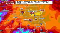
August would prove to be a big month for southern Wisconsin as heavy rains fell across southern Wisconsin, particularly August 9th into August 10th.
Thanks to a moist airmass overhead and a stationary/stalled front that was stretched from east to west, rounds of showers and thunderstorms moved across western, central and eastern parts of southern Wisconsin.
maxuser
Milwaukee and its surrounding suburbs recorded the most rain from this event, with many areas recording at least a half a foot of rain falling. However, one rain gage, on Milwaukee’s northwest side, recorded a 24 hour total rainfall reading of 14.55″. Though it would take months of careful deliberation from a number of weather organizations, the report was found to be credible and would go on set a new record for Wisconsin’s rainiest 24 hours.

While heavy rain fell in the Milwaukee area, heavy rain also fell on the opposite side of the state. Parts of Grant and Crawford counties recorded 24 hour rain fall totals between 6-10″. Boscobel, in particular, was hit by flood waters with some living in the city taking damage to their homes.
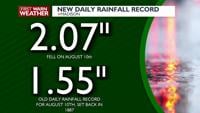
Additionally, Madison set a new daily rain fall record for August 10th, picking up just over 2″ of rain in 24 hours.
maxuser
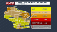
September and October were particularly dry months for Wisconsin, both months missed over an inch of rain statewide. However, Lafayette County claimed the driest county in Wisconsin throughout September with only 0.56″ recorded for the month.
The dry conditions helped expand the drought conditions across the state; the state went from virtually no drought conditions in July to 40% of the state suffering from moderate drought conditions by early November. By early December, nearly 57% of the state was suffering from moderate drought conditions, 13% of the state suffering from severe drought conditions and 98% suffering from abnormally dry conditions.
In the middle of November, a strong solar storm moved across the Earth, creating a strong display of the Northern Lights across southern Wisconsin. On November 11th, many across southern Wisconsin were able to see impressive greens and reds dance across the sky.
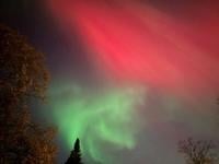
Northern Lights in Verona on November 11th, courtesy of Julie Cline
Nearly all of November was quiet and mild, with a few little snow showers here and there, but it was at the end of November that Wisconsin got its first big snow storm of Winter 2025 – 2026.
A Colorado Low moved into the Midwest November 29th, moving in plenty of moisture into a cold air mass that was sitting overhead. The cold air, the moisture and the size of this low pressure system, meant that heavy snow fell throughout the daytime hours.
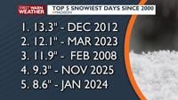
By the time it was all said and done, some parts of Wisconsin picked up 12″ of snow. Madison picked up 9.3″ on the 29th with an additional 2.4″ falling on the 30th. This strong low also ushered cooler, more winter like air, that would stick around through most of December. Because of that, most of the snow that fell the weekend after Thanksgiving was on the ground through Christmas.
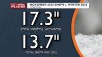
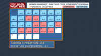
Officially making Christmas 2025 for the Madison area a white one, despite a mild stretch of air overhead beginning December 22nd. Despite the warmer temperatures for nearly a week, December was still cooler than average, at the time of this article, with the average temperature 5.1° degrees cooler than average from the start of the month through December 27th.
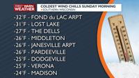
Also at the time this article was written, another large system is set to move through the Midwest Sunday, December 28th, through Monday, December 29th. This system will likely bring another round of heavy snow to north and central parts of Wisconsin along with strong wind gusts. This strong cold front will also cause temperatures to come crashing down throughout the day on Sunday, dropping from the mid 40s to the mid 10s by Sunday night.

COPYRIGHT 2025 BY CHANNEL 3000. ALL RIGHTS RESERVED. THIS MATERIAL MAY NOT BE PUBLISHED, BROADCAST, REWRITTEN OR REDISTRIBUTED.