

Those seeing in 2026 by celebrating outside will need to wrap up warm. Temperatures as low as -17C are forecast, with continued snowfall, though lower wind speeds than we have been seeing in recent days.
A low-pressure system which has been shaping the recent stormy weather in Estonia and led to the appearance of Storm Johannes over the weekend, continued to move eastwards Tuesday. Its western edge remained over the Baltic states through to the end of the day. A narrow ridge of high pressure will next form up over the Baltic Sea, bringing somewhat clearer skies.
The snow showers will continue to shift mainly to eastern Estonia, and the still quite strong winds will gradually continue to weaken. By the final evening of 2025 it will also be clearer in the east, but with this will come a drop in temperatures to see in the New Year.
The snow continued to fall on the mainland overnight Tuesday to Wednesday, driven by northwesterlies. With temperatures below zero everywhere, down to -9C in central Estonia, the dawn will bring even more snow cover than seen Wednesday.
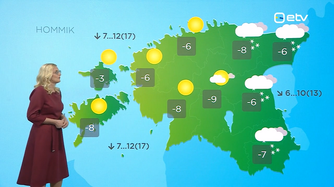 Weather map for the morning of December 31, 2025. Source: ERR
However, the change in dominant weather systems noted above means the western half of Estonia, including Tallinn and Pärnu, will be waking up on December 31 to much clearer skies than seen recently, and little to no snow.
East of a line running roughly from Rakvere to Valga, heavier snowfall will continue in the morning, however. Northwesterly winds will blow at speeds of 5 to 12 m/s, with coastal gusts still reaching a pretty fresh 17 m/s.
Ambient temperature in the morning will remain cold and at the same levels as those seen overnight. Temperatures s low as -9C and even -8C on Saaremaa are due, though immediate coastal areas will have milder conditions at -4 to -2C.
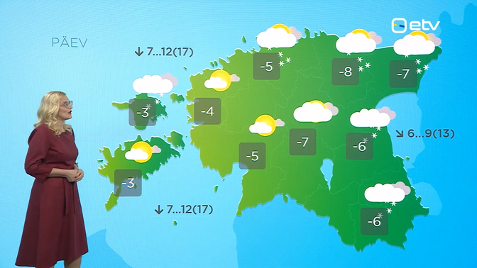 Daytime weather outlook for December 31, 2025. Source: ERR
These temperatures are barely set to rise daytime, save for in the westernmost parts of the country. Subzero conditions remain the order of the day, again as low as -8C, with the same northerlies keeping things feeling even colder. The snow will continue and come back as far west as Tallinn daytime, and will drift in places, so take care when out and about. The skies in the west, while still mostly clear, will see more cloud cover after lunch.
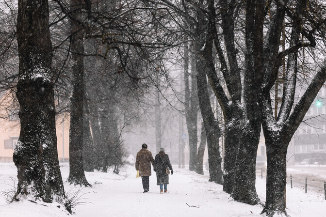 Tallinn had already seen blizzard conditions on the penultimate day of the year, December 30. Source: Ken Mürk/ERR
Heading into the final hours of 2025, snowfall will continue and the temperatures will drop further still, as low as -17C inland and no lower than -8C, save for immediate coastal areas in the west, where it will still be -3C.
On New Year’s Day itself, Thursday, there won’t be much respite from this. Temperatures are forecast to still be −9 to −3C. There may be some local pockets on the islands where the ambient temperature will be as “warm” as around zero. The snow will continue to fall and will also drift, though on the islands there can also be sleet and rain at times when the mercury rises a bit higher. This brings a risk of icy conditions which can make driving hazardous.
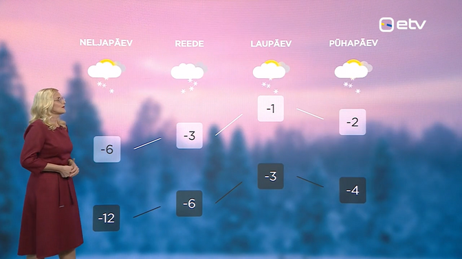 Forecast for the first four days of 2026. Source: ERR
Wintry conditions will persist into the weekend, though the sun will make an appearance from time to time. Average temperatures will be a bit milder, from -6C overnight Thursday to Friday to -3C the following night, and from -1 on average Saturday daytime, slightly chillier Sunday. The snow will continue to fall over the weekend too.
—