

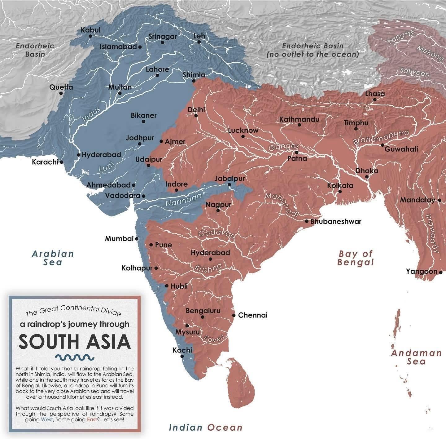
This map shows how South Asia is split by a natural watershed, determining the direction in which rivers—and even a single raindrop—flow.
Blue regions drain westward into the Arabian Sea (Indus, Narmada, Tapi, etc.).
Red regions drain eastward into the Bay of Bengal (Ganga, Brahmaputra, Godavari, Krishna, Kaveri, etc.).
A raindrop falling just a few kilometers apart can end up in entirely different oceans, traveling thousands of kilometers before reaching the sea…
Posted by Familiar-Surround-64
19 Comments
Very cool map. Is there a global version?
Okay, this one is genuinely interesting
Cool map. Rivers Look like veins of a leaflet
Wouldn’t that be a Subcontinental Divide?
Interesting. I’d like to see what that looks like in other areas too!
It’s a nice map but all the water flows to the same ocean – “Great” is a bit overstated. Is there an area where water might flow to either the Indian Ocean or the Arctic, Atlantic, or Pacific? That would be more of a continental divide, and more impressive.
This makes Pakistan/India border make more sense
From a geographic, commercial, and administrative perspective, Jabalpur is in a perfect location. Was it ever a capital to an empire? Big trading city? I legitimately dont know and am wondering if anybody knows
This is not South-Asia.
This helps explain why some of those rivers act the way they do.
Fascinating. Probably can explain a lot of esoterica of history with this map handy.
Hence, Indo-Gangetic plain. I had no idea that only Kabulistan is riparian to the ocean for Afghanistan
The true East vs West divide
Better split than the one Brits did
Nope. The red should reach the eastern side of Lake Manasrovar, as the Brahmaputra flows out of it too (in addition to the Sutlej shown here and the Indus which is cut short on the map but also comes from Lake Manasrovar).
Please credit Perrin Remonté (aka u/mydriase ) and his website Perrinremonte.com
He the creator of this map.
Why did you crop my website and name on the map??? Wtf is wrong with people on Reddit
Shameless repost
The blue section kind of resembles the general area of the Indus Valley Civilization. Most of it was in modern day Pakistan plus a small section in modern day India.
Supposedly if civilization was to start again, the Bay of Bengal is apparently the best place on earth to turbocharge our redevelopment
I’ll have to find the article that said that but i found it fascinating