

Alongside the winds last night there was also a massive temperature spike that’s (probably?) broken the existing overnight record of 30.6. I’m at work and can’t turn on a TV so maybe it’s being covered Please post below if you’ve seen any new stories!
Understandably there are much bigger weather and fire concerns taking place today. Let’s hope we don’t see more records fall.
Be safe out there, and give yourself a little grace if you had a shocker of a sleep!
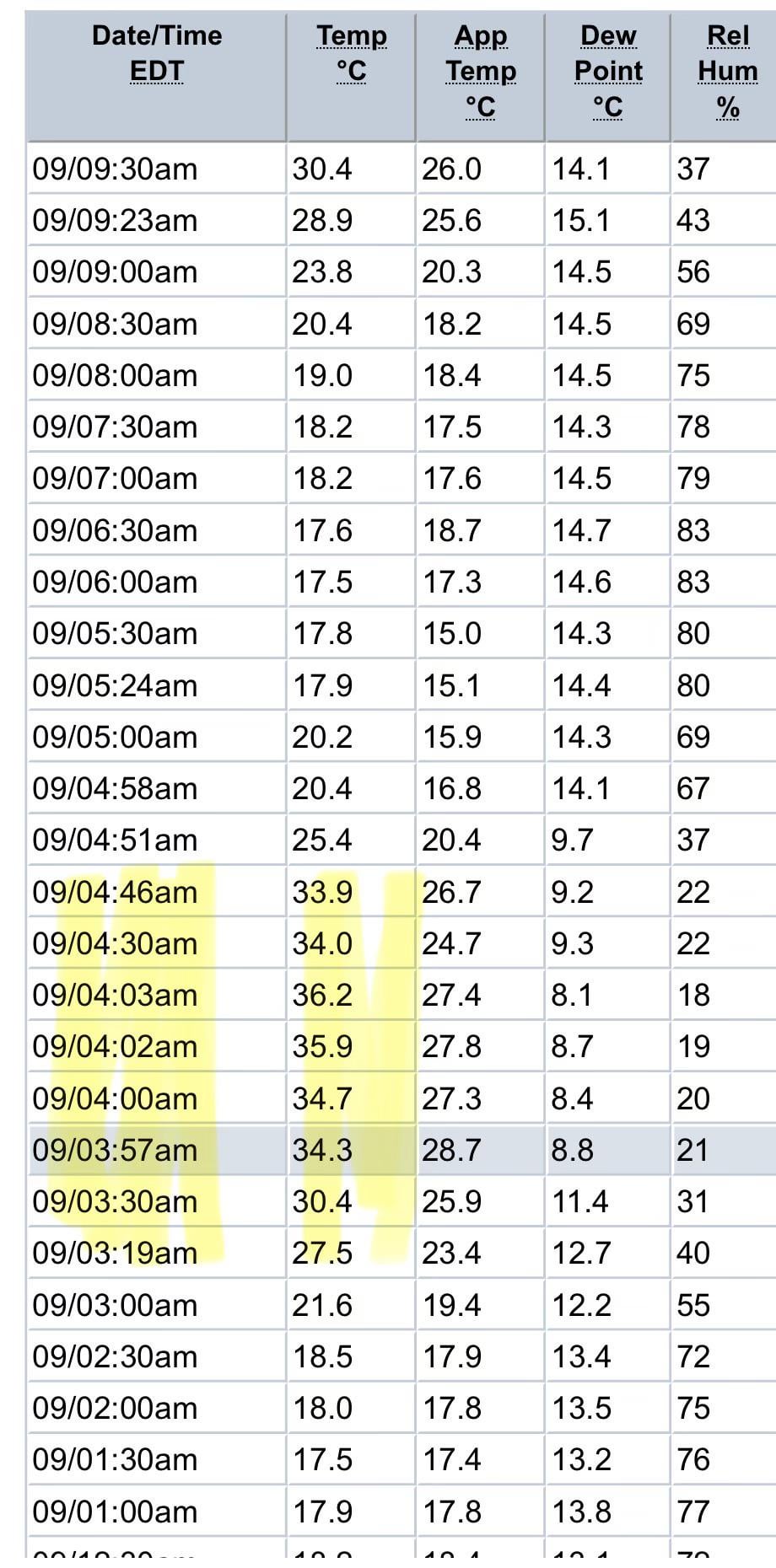
Screenshot from the BOM Melbourne Airport weather station observations page.
Edit: repeated myself 3 times – apologies.
Thank you for the good info, it's not a record because the overnight low was much lower, but certainly a unique weather event!
Also, this didn't impact all of Melbourne. You can check your local weather station below 🙂 https://www.bom.gov.au/vic/observations/melbourne.shtml
Posted by 99ninenine
21 Comments
I do recall a New Year’s Eve back a few decades where it was still 40C at midnight.
Did the sun come out at 3am?
how would this happen? seems incredibly strange but I also have no idea
that explains why i slept like shit
Defs wasnf 36 in my area. If anything was high teens
out in the SE burbs it wasn’t hot at all last night, low 20’s when i walked the dog around 9am.
Well over 30 and a stiff wind now though.
We actually had a cool breeze come through overnight where I am. Was still nice this morning at 9am. I was quite surprised, not looking forward to it warming up.
It won’t be valid for any overnight temperature records, the airport still dropped to 17.5° on either side of the spike and 17.2° before the spike which is what the overnight temperature will be recorded as, but it’s certainly an unusual occurrence.
As for why it happened, it was essentially a [heat burst](https://www.weather.gov/abq/localfeatureheatburst ) under the down-drafts of the high based storms that were passing through at the time.
The air at ~1km in altitude was blowing a brisk northerly and was much warmer than the air at the surface thanks to a shallow temperature inversion pushing in a cooler southerly wind at ground level.
The hot and gusty elevated northerly wind got dragged down to the surface in the down-drafts of the thunderstorms that passed through earlier in the morning which is when the temperature got pushed up to 36° with wind gusts approaching 90km/h at Tulla.
As the storms subsided and moved further out towards the east, the hot northerly down-drafts were replaced at the surface with the cooler southerly sea breeze and storm outflow, pushing the temperature back down towards 20º.
Going from 18 at 2am to 35.9 at 4am back down to 18 by 5:30am is wild
Your data source looks weird. I’m looking at data on the BOM website and temp was around 19 – 21 degrees during your time range.
i woke up due to the wind at around 4am, i stood outside and the heat was unbeliveable.
I’d call this an anomaly, but Essendon Airport just up the road did see a sudden rise and fall in temperature at this time.
It was 21.2 at 04:30, 29.5 at 04:33, 22.8 at 04:44 and then hitting the teens by 04:51.
[Latest Capital City Observations Essendon Airport](https://www.bom.gov.au/products/IDV60901/IDV60901.95866.shtml)
Yea is low-key cooked and the surrounding areas 🙏
I was out on my balcony at 1am last night, and that 17.5 with a breeze was so beautiful. Lapped it up knowing what was to come. Weird to see temperature go up again at that time though(?).
Seemed pretty cool in melton
**For some clarity**: this is a storm surge that pushed across from the north west, through Taylors Lakes and the Airport, across the northern and north-eastern suburbs and then split around the Dandenongs, hitting places like Healesville and Belgrave on either side. Spikes like this were recorded at Mel Airport, Essendon Airport Viewbank, Scoresby, Coldstream, and Ferny Creek (just outside Belgrave).
Essentially big wind gusts came through with huge temp increases over the course about 45-60 mins and then dropped off again. None of the CBD or weather stations geographically south of there were impacted.
Brunswick West here getting weather from Essendon Airport. I was awake and outside during this time and the temp DID NOT spike like this. I was wondering myself what had happened. Figured something went wrong
The minimum was lower, which is what’s recorded.
Weird, my at home (and clearly unofficial) gauge had a slight increase from 17 to 21 degrees at that time, but nothing like that.
To be fair I’m opposite site of Melbourne to the airport.
Official Melb temps (since it moved from Vic Pde) are at Olympic Park anyway [https://www.bom.gov.au/products/IDV60901/IDV60901.95936.shtml](https://www.bom.gov.au/products/IDV60901/IDV60901.95936.shtml)
I saw that spike on my outdoor thermometer last night when I was looking at it this morning and thought it was some glitch with the system. Wild to see it replicated by official data! The humidity also plunged by over 25% at the same time.