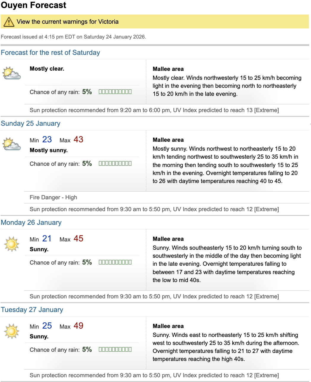
49º, if the forecast holds, would see us break the current all time Victorian maximum temperature record of 48.8º set at Hopetoun during the Black Saturday heatwave.
Bringing it back to Melbourne, we’re also currently forecast to see maximums up to 45º on Tuesday, with the highest temperatures expected across the north side of the city, spanning from the Melton area in the west all the way across to the Templestowe and Doncaster region in the east.
Interestingly, this heatwave is at least partly being driven by Tropical Cyclone Luana that’s currently making landfall across the northwest Kimberley Coast in WA. There’s a bit of technical dynamics to it but it’ll essentially help to strengthen the ridge of high pressure in the upper levels of the atmosphere which slows down the atmospheric circulation and allows the heat from the interior of the country, as well as the warm air flowing out of the top of the cyclone, to spread across the southeast of the country and stagnate for an extended period of time.
It was actually a very similar process that brought the widespread heatwave conditions of Black Saturday while Cyclone Dominic hit the WA coast near Onslow in the days before the fires broke out. Thankfully though, the winds aren’t looking quite as bad this time compared to 2009, but it’ll still be a week of dangerous fire conditions with emergency warnings for the Otways fire already being reissued this afternoon after it jumped containment lines.
While Tuesday should be the last day that the upper level ridge has an influence on our weather in Melbourne, it will likely persist over inland regions for the entire week, with parts of northern Victoria and western NSW possibly seeing temperatures in the mid-high 40s continue through to the start of February.


15 Comments
49º, if the forecast holds, would see us break the current all time Victorian maximum temperature record of 48.8º set at Hopetoun during the Black Saturday heatwave.
Bringing it back to Melbourne, we’re also currently forecast to see maximums up to 45º on Tuesday, with the highest temperatures expected across the north side of the city, spanning from the Melton area in the west all the way across to the Templestowe and Doncaster region in the east.
Interestingly, this heatwave is at least partly being driven by Tropical Cyclone Luana that’s currently making landfall across the northwest Kimberley Coast in WA. There’s a bit of technical dynamics to it but it’ll essentially help to strengthen the ridge of high pressure in the upper levels of the atmosphere which slows down the atmospheric circulation and allows the heat from the interior of the country, as well as the warm air flowing out of the top of the cyclone, to spread across the southeast of the country and stagnate for an extended period of time.
It was actually a very similar process that brought the widespread heatwave conditions of Black Saturday while Cyclone Dominic hit the WA coast near Onslow in the days before the fires broke out. Thankfully though, the winds aren’t looking quite as bad this time compared to 2009, but it’ll still be a week of dangerous fire conditions with emergency warnings for the Otways fire already being reissued this afternoon after it jumped containment lines.
While Tuesday should be the last day that the upper level ridge has an influence on our weather in Melbourne, it will likely persist over inland regions for the entire week, with parts of northern Victoria and western NSW possibly seeing temperatures in the mid-high 40s continue through to the start of February.
Further reading on the dynamics of WA tropical cyclones being connected to heatwaves across southeastern Australia: [https://apac.dtn.com/energy/how-tropical-cyclones-and-heatwaves-are-connected/](https://apac.dtn.com/energy/how-tropical-cyclones-and-heatwaves-are-connected/)
Thanks for this OP. Any chance the max temperature could get downgraded or is it looking like a firm prediction?
Check out Mildura’s run. I doubt they’ll break their record of 12 consecutive days over 40 from 2009, but it’s still a tough week.
https://preview.redd.it/3tlh6jcmv8fg1.jpeg?width=1125&format=pjpg&auto=webp&s=51821d0b9ce8f849d48b70aca8e2760917b218d3
Sweet Jesus, I’ve never seen a BOM forecast like that. Take all precautions for you and your furry friends, my dude.
“Sunny.”
What does 49° even *feel* like? I can’t even imagine.
Cool and normal
Really hoping I don’t look in the comments and see the ‘it’s just summer’ type replies.
Just want my normal grey sky, 13C days back.
Yeah, but, it’s the humidity that hurts.
Good day to go to the Ouyen pool
No thank you
Jesus fuck
Insane.
Think Hopetoun (Black Saturday) nearby holds the VIC record.
Melbourne (same day) holds the capital city record.
Sunny