
Posting here because it's been a day and no one's replying to it under the general questions area. I've seen variations of this questions being asked ~10 years ago with barely a response, so I wanna kick it up again.
I’ve personally always seen the Earth as Blue, Green, and White, but I only think so because I’ve seen photographs of the Earth from the 1960s and 70s. I’ve looked into depictions of Earth before this time, and they all seem to be really dull, with the landmasses slightly colored to distinguish the separation between countries.
Taking this into account, it kind of makes sense why people were so optimistic that other celestial civilizations existed, like people on the moon or Mars, despite their odd color. Maybe it’s because they had no frame of reference.
Found a cool article on it as well: What Did People Think Earth Looked Like Before We Actually Saw It?
TLDR: The article says that people pretty much had the colors and stuff right even before the photographs. Booooo boring answer, but I suppose it makes sense. I don't know if they got the white clouds right though.
But if anyone wants to share their two cents, that'd be greatly appreciated.
And if you happen to have only seen pictures of the Earth until you were older in life (late teens or twenties), I’d love to hear your perspective! Or ask someone who does (maybe a parent / grandparent)
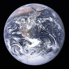
https://i.redd.it/7e6vl0lf12hg1.png
18 Comments
I mean you don’t need to go into space to see that clouds are white, oceans are blue and areas covered in plants are green
There were globes for centuries before anyone photographed earth. I don’t think anyone was shocked by earth’s appearance when we finally photographed it. I think the only thing that changed was the appreciation of how alone and fragile it looks just sitting there in the black of space.
Look at a desktop globe made before 1950. That. Plus clouds, they knew there were clouds too.
e.g. [https://www.reddit.com/r/MapPorn/comments/t9pknx/i_found_a_globe_from_the_late_1940s/](https://www.reddit.com/r/MapPorn/comments/t9pknx/i_found_a_globe_from_the_late_1940s/)
Maybe like this: [https://static.wixstatic.com/media/03249d_73cbf4b66af044429b5ea28fcfd5df22~mv2.png/v1/fill/w_438,h_329,al_c,q_85,usm_0.66_1.00_0.01,enc_avif,quality_auto/03249d_73cbf4b66af044429b5ea28fcfd5df22~mv2.png](https://static.wixstatic.com/media/03249d_73cbf4b66af044429b5ea28fcfd5df22~mv2.png/v1/fill/w_438,h_329,al_c,q_85,usm_0.66_1.00_0.01,enc_avif,quality_auto/03249d_73cbf4b66af044429b5ea28fcfd5df22~mv2.png)
They assumed it looks exactly the way it does. You don’t need a lot of imagination to figure out how your own planet looks like from its orbit.
With weather balloons and airplanes with aerial cameras, they probably had a good idea by the 1940s. Before 1900 might be more interesting to see how accurate the landmasses were illustrated.
The first picture of earth was made [October 24th 1946](https://en.wikipedia.org/wiki/Timeline_of_first_images_of_Earth_from_space).
So we needed arts or maps before this date.
Why wouldn’t they get the white clouds right? Most days you can just look up and see them after all.
Those who thought the earth was flat had hand-drawn maps. The Library of Congress has an interesting collection here: [https://blogs.loc.gov/maps/2025/03/unconventional-theories-about-the-earths-shape-both-ancient-and-modern/](https://blogs.loc.gov/maps/2025/03/unconventional-theories-about-the-earths-shape-both-ancient-and-modern/)
Not sure what people today do when they say they believe the earth is flat. It’s sad.
the oldest known globe of earth dates to 1490..
https://en.wikipedia.org/wiki/Erdapfel
There’s too many people here confusing what a map is and what an illustration of the planet as seen from space is.
Most of the early artistic images of the earth as imagined from space tended to forget about the visual impact of clouds. They usually showed the land masses as clearly defined when, in fact much is hidden behind clouds. They also usually overestimated the amount of green yet imagined the blue of the oceans to be a lot lighter.
Eratosthenes attempted to measure Earth’s circumference and even its axial tilt in the 3rd century BC, and his measurements were not far off from modern values. By Roman times it was common knowledge. We can all see what the world looks like around us with its land, clouds and vast oceans, so it makes sense that these features extended across the entire planet.
I’m always surprised by how dominant the clouds are in all the pictures of earth.
Well you could go watch 2001: A Space Odyssey. That movie famously depicts earth in full profile but was actually made before we got back any actual pictures of earth from space. So Kubrick basically gave it his best guess.
The movie “2001 A Space Odyssey” was made before they were sure what the earth looked like from space. I’d say that they [got it pretty close](https://static.wikia.nocookie.net/2001/images/c/c4/68BF5430-D018-4175-B750-7B3B597BFC8C.jpeg/revision/latest/scale-to-width-down/1000?cb=20190122035632), all things considered.
This [wikipedia article](https://en.wikipedia.org/wiki/Timeline_of_first_images_of_Earth_from_space) will also help.
The whole irony is there are morons who think the earth is flat even after this picture
“See! That thing looks pretty flat to me!”