

Iran may be using a Chinese satellite navigation system to target Israel and United States military assets in the Middle East, intelligence experts say.
Former French foreign intelligence director Alain Juillet told France’s independent Tocsin podcast this week that it is likely that Iran has been provided access to China’s BeiDou satellite navigation system because its targeting has become much more accurate since the 12-Day War with Israel in June.
“One of the surprises in this war is that Iranian missiles are more accurate compared to the war that took place eight months ago, raising many questions about the guidance systems of these missiles,” Juillet, who served as the director of intelligence for the General Directorate for External Security from 2002 to 2003, told Tocsin.
In response to the US-Israeli attacks that began on February 28 and the killing of top Iranian figures, including Supreme Leader Ali Khamenei, Iran has launched hundreds of ballistic missiles and drones towards Israel and US facilities in Gulf nations.
Although Israel and Gulf nations have intercepted many of these incoming missiles, several have breached the countries’ defences, causing significant damage and casualties.
While the US can jam or deny access to the US government-owned Global Positioning System (GPS), which Iran’s military previously relied on, it cannot do much to interfere with China’s BeiDou system if that is what Iran is using. Iran has not confirmed or commented on this.
Here is what we know about BeiDou and whether Iran’s potential use of it could mark the end of the US monopoly on real-time satellite intelligence in the battlefield.
What is the BeiDou Navigation Satellite System (BDS)?
China launched the latest version of its satellite navigation system, billed as rivalling GPS, in 2020. Chinese President Xi Jinping officially commissioned the system in a July 2020 ceremony at the Great Hall of the People in Beijing.
China began development of its own satellite navigation system after the 1996 Taiwan crisis because it feared Washington could restrict access to GPS in the future.
According to the Chinese government website for BeiDou, the aim of the system is to “serve the world and benefit mankind”.
Crucially, China’s system uses far more satellites than other navigational systems. According to data gathered by Al Jazeera’s AJ Labs data team, while the US GPS system has 24 satellites providing it with data, the Chinese system relies on 45. The two other main global navigation systems are Russia’s GLONASS and the European Union’s Galileo system, each of which have 24 satellites.
The BeiDou website said the system is comprised of three segments – a space segment, a ground segment and a “user” segment.
“The BDS ground segment consists of various ground stations, including master control stations, time synchronisation/uplink stations, monitoring stations, as well as operation and management facilities of the inter-satellite link,” the website said.
“The BDS user segment consists of various kinds of BDS basic products, systems, and services as well as those compatible with other navigation systems, including basic products such as chips, modules and antennae, terminals, application systems and application services.”
Like other satellite navigation systems, BeiDou, which offers worldwide coverage, works by transmitting timing signals from satellites to receivers on the ground or in vehicles. By measuring the time it takes for signals from several satellites to reach the receiver, the system can calculate a precise geographic position.
“Accuracy varies depending on the level of service,” Brussels-based military and political analyst Elijah Magnier said. “The open civilian signal generally provides positioning accuracy of around five to 10 metres, while restricted services available to authorised users can offer much higher precision.”
Could Iran be using BeiDou?
Iran has not confirmed this. It is also unclear whether systematically switching military operations to a different satellite navigation system would even be possible in such a short space of time since the June war with Israel last year.
Following that conflict, Iran’s Ministry of Information and Communications Technology stated that Iran uses “all existing capacities in the world and does not rely on a single source of technology”.
However, Juillet told Tocsin that a switch to China’s BeiDou system is a realistic explanation for how Iran has improved its targeting accuracy so much since last year.
“There is talk about replacing the GPS system with a Chinese system, which explains the precision of Iranian missiles. … Significant targets have been hit.”
How could using BeiDou improve accuracy in targeting?
The BeiDou system could be used to guide Iran’s ballistic missiles with much greater accuracy than before.
Magnier explained that until now, Iranian missiles and drones have been widely believed to rely primarily on inertial navigation systems. “These systems determine a weapon’s position by measuring acceleration and motion through onboard sensors such as gyroscopes and accelerometers. Inertial navigation offers the advantage of being self-contained and resistant to external interference,” he told Al Jazeera.
“However, it has a significant limitation: small measurement errors accumulate over time and distance, progressively reducing accuracy. Satellite navigation signals address this issue.”
Magnier added: “Typically, a missile uses inertial navigation to maintain its general trajectory while satellite signals refine the path and enhance targeting precision. This approach results in a substantial improvement in accuracy.”
He said it would make sense for Iran to use multiple navigation systems, rather than just relying on one.
“Simultaneous use of multiple satellite systems provides an additional advantage: resilience against jamming or signal disruption,” he explained. “In contested environments, navigation signals may be deliberately interfered with. If a weapon depends on a single satellite system, disruption of that signal can degrade accuracy. However, guidance systems capable of receiving signals from multiple constellations are more resistant to complete navigation denial. Furthermore, access to more satellites improves signal geometry, thereby enhancing positional accuracy.”
The Chinese navigation system is believed to have a “margin of error” of less than 1 metre (3.3ft), which means it is highly precise. It can also automatically correct target directions if they move, analysts said.
Furthermore, it will likely help Iran to get around Western jamming systems used by Israel during the 12-Day War last year. They successfully deflected Iranian drones and missiles – which were using GPS signals to navigate – in 2025. Jamming techniques include tricking incoming drones with false coordinates. The BeiDou system can filter out such interference.
Military analyst Patricia Marins told the news outlet bne IntelliNews this week: “Unlike the civilian-grade GPS signals that were paralysed in 2025, BDS-3’s military-tier B3A signal is essentially unjammable.”
The system uses “complex frequency hopping and Navigation Message Authentication (NMA), which prevents ‘spoofing’”, she added.
BeiDou also has a short message communication tool that allows operators to communicate with drones or missiles as far away as 2,000km (1, 240 miles) while they are in flight. This means they can potentially be redirected after launch, Marins said.
If it has it, Iran’s access to BeiDou technology is a game-changer, analysts say.
“The evolution of satellite navigation has transformed the landscape of modern warfare,” Magnier said. “Precision strike capability, once the preserve of a handful of advanced military powers, is increasingly shaped by the availability of global navigation infrastructure. As long-range weapons become more accurate and more resilient to interference, systems such as BeiDou will continue to play a significant role in the technological foundations of contemporary conflict.”
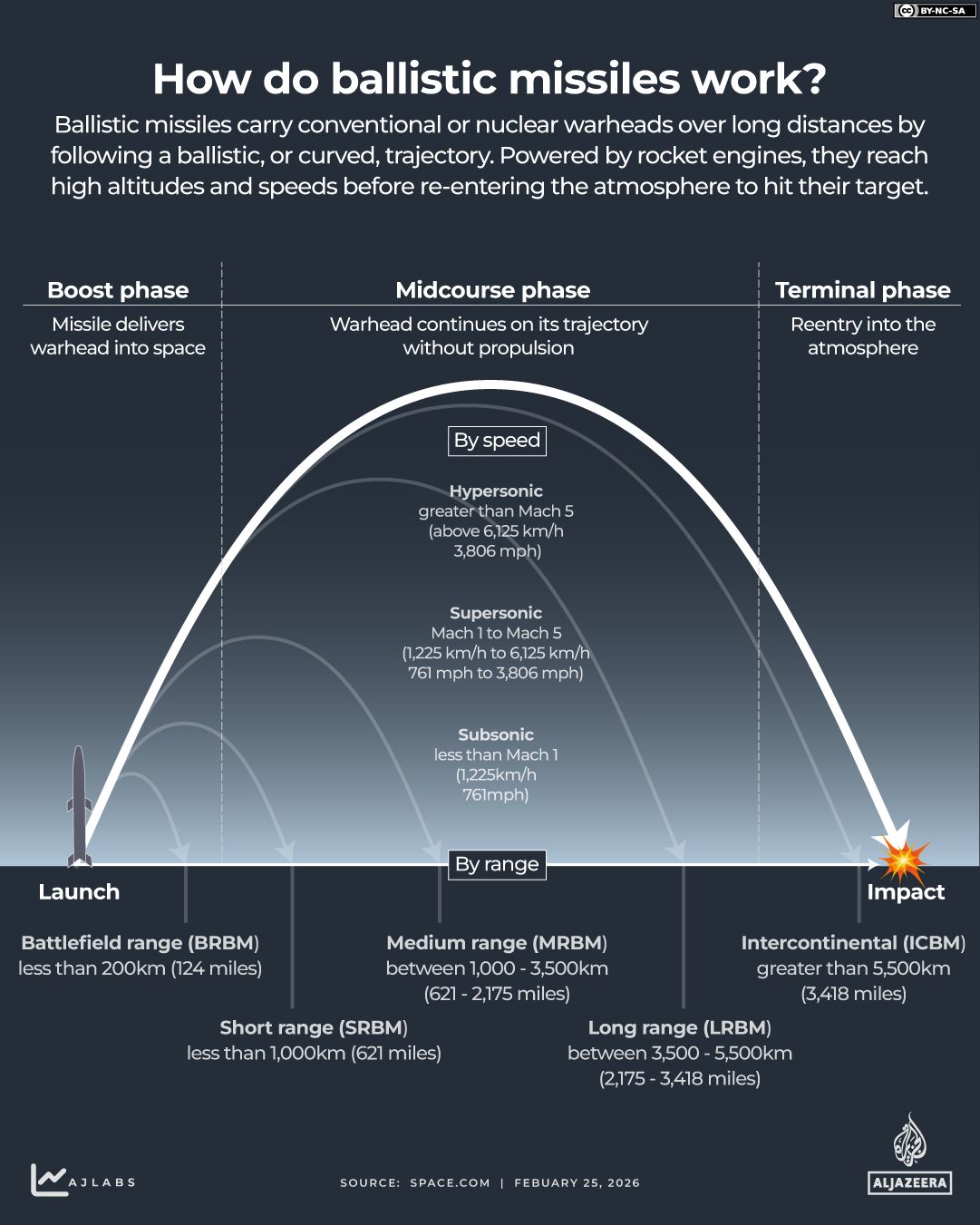
How many ballistic missiles does Iran have?
While the exact size of Iran’s ballistic missile arsenal is not known, it is widely considered one of the largest and most advanced in the region. Ballistic missiles can travel distances ranging from a few hundred kilometres to more than 10,000km (6,200 miles) across continents.
Juillet told the Tocsin podcast that while the Israeli and US air forces claimed to have destroyed all identifiable targets in Iran, the exact number and distribution of Iranian missiles is unknown.
“Iran is three times the size of France, and the missiles are mounted on trucks dispersed across the country. How can one track these trucks in such a vast area?”
He added that it is likely that Iran is deploying its missiles more “judiciously” than it did in the 12-Day War in anticipation that the current war may be prolonged.
In the meantime, there are concerns on the US side that its store of expensive interceptor missiles could be depleted by taking down cheap Iranian Shahed drones before Iran even has to use many of its ballistic missiles.
For this reason, US President Donald Trump’s administration has asked Ukraine, where Russia is using Iranian-made Shahed drones, to share the interceptor technology it has developed and mass-produced.