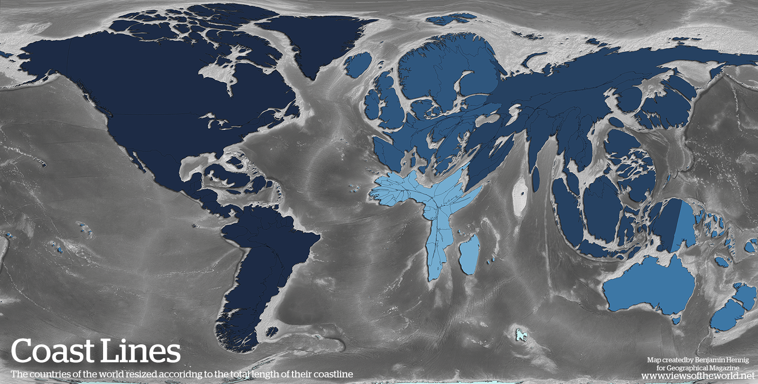
Europe is a peninsula of peninsulas. There’s nothing else like it
Toastaexperience on
I for one like thiccc New Zealand.
Hached200 on
New Zealand’s thick
lNFORMATlVE on
Is this really true or has Africa’s coastline simply not been mapped to such a fine degree (and has then just been linearly interpolated) in readily accessible data because it is typically forgotten/ignored in a worldwide economic sense?
Emotional-Ebb8321 on
The fractal sampling errors in this map are rather obvious.
Danskoesterreich on
what are those colors? what are they showing?
adrianb on
Benoit Mandelbrot would like to chat
Arctic-Rumble on
Ooooh finally Thicc Norway
ctothel on
~~This is super interesting but isn’t it a bit confusing to base it on the Mercator projection?~~
Edit: I could be wrong. I’ll edit again if OP clarifies
WIZZZARDOFFREESTYLE on
Can someone explain to dumbass me what exactly is this showing?
DrainZ- on
One great feature with this map is that countries with long perimeter relative to their size being bloated up makes it more visible how jagged their shoreline is. Especially Norway.
EggoSkrr on
This has had a massive effect on trade and economy in the history of humans.
Longer coastline means more harbours and cover, protecting societies and easier to station and protect ships for trade and navy. Linear coastlines are difficult to anchor and breach. This knock on effect is one of the reasons Europe historically prospered (at least in the post-shipbuilding era) and Africa has struggled economically. Also explains why the mass European migration to North America was easier in terms of the actual travel and why creating colonial settlements was so easy.
Idk if it’s this black and white but certainly played a part.
Skeledenn on
Thanks I hate this
platinum_192 on
Chile no longer stringy
Quiet-Wing5230 on
Canada and Norway looking swoll
No-Statement2736 on
African geography is hard mode
Ok-Temperature1516 on
Doesn’t the US have a massive coastline on the east coast? Why is this not represented here?
Illustrious-One5348 on
Greece and Croatia be like:

AcanthisittaBorn8304 on
I love how Australia is basically… just Australia.
Impressive_Term_9248 on
Obviously, the blue part is land.
ClearlyCylindrical on
Chesapeake bay seems underrepresented, must have a relatively low resolution
cpteric on
thick zealand over tere
Fortheweaks on
Australia be like : are you guys ok ?
FabienPr on
Big day for Chile
jantoxdetox on
Philippines turned from Small Dog Lying Down to Thicc Beaver Lying Down
jhs172 on
Thanks, Slartibartfast!
gpolk on
I love how Australia just looks pretty much the same. And Thicc New Zealand next door.
Ike358 on
All coastlines are infinitely long
Defiant_Size5991 on
It’s wild how that fractal coastline effect makes Europe seem so much larger than it is on a map. The “peninsula of peninsulas” thing is a perfect way to describe it. It really makes you think about how much detail gets lost in a simple outline. That’s probably why cartographers have such a tough job.
ScoffSlaphead72 on
idk what this map is but BBW New Zealand is sending me wild.
malev89 on
Dude, what happened to New Zealand. She was so thin when they filmed TLOTR there… now. Does anybody know what happened to her? Bad break up?
REALtirefire on
Post is about Europe but I’m stuck on Indonesia
Triepott on
But arent coastlines like fractals and therefore unlimited long?
DasFreibier on
is that actual true or a product of map resolution differences?
cnzmur on
Is this the case, or is it partly that European countries are just surveyed to a much higher precision than African ones?
mitaciolanu on
What the hell am I even looking at
King_Ethelstan on
Controversial, but its one of the reasons why Africa is poor. Few and shallow coastlines prevent maritime trade
Six_Six_Six_Is_r3d3t on
My brother in Christ, why have you done Maine dirty like this?
Jaymac720 on
I’m very confused by this map
SaintBobby_Barbarian on
Africa is such an interesting continent geographically. Basically one large plateau, so many rivers that see water falls that impede traditional riverine navigation, rift valley mud volcanoes, the Sudd swamplands of the upper nile that impeded ancient travelers from getting deeper into Africa
Slartibartfast39 on
You’re welcome Norway.
Zippytiewassabi on
Is this just saltwater coastline or does this include freshwater coastline? For example in the US, are the Great Lakes doing some heavy lifting for the US projection?
Jeppep on
🇳🇴
rab777hp on
Nonsense. How “long” a coastline is is a function of how much money you spend on measuring it. So of course Europe will seem to have more.

 is huge. Africa on the other hand has a very linear shoreline")
46 Comments
Every coastline is essentially infinite.
Africa be like

Europe is a peninsula of peninsulas. There’s nothing else like it
I for one like thiccc New Zealand.
New Zealand’s thick
Is this really true or has Africa’s coastline simply not been mapped to such a fine degree (and has then just been linearly interpolated) in readily accessible data because it is typically forgotten/ignored in a worldwide economic sense?
The fractal sampling errors in this map are rather obvious.
what are those colors? what are they showing?
Benoit Mandelbrot would like to chat
Ooooh finally Thicc Norway
~~This is super interesting but isn’t it a bit confusing to base it on the Mercator projection?~~
Edit: I could be wrong. I’ll edit again if OP clarifies
Can someone explain to dumbass me what exactly is this showing?
One great feature with this map is that countries with long perimeter relative to their size being bloated up makes it more visible how jagged their shoreline is. Especially Norway.
This has had a massive effect on trade and economy in the history of humans.
Longer coastline means more harbours and cover, protecting societies and easier to station and protect ships for trade and navy. Linear coastlines are difficult to anchor and breach. This knock on effect is one of the reasons Europe historically prospered (at least in the post-shipbuilding era) and Africa has struggled economically. Also explains why the mass European migration to North America was easier in terms of the actual travel and why creating colonial settlements was so easy.
Idk if it’s this black and white but certainly played a part.
Thanks I hate this
Chile no longer stringy
Canada and Norway looking swoll
African geography is hard mode
Doesn’t the US have a massive coastline on the east coast? Why is this not represented here?
Greece and Croatia be like:

I love how Australia is basically… just Australia.
Obviously, the blue part is land.
Chesapeake bay seems underrepresented, must have a relatively low resolution
thick zealand over tere
Australia be like : are you guys ok ?
Big day for Chile
Philippines turned from Small Dog Lying Down to Thicc Beaver Lying Down
Thanks, Slartibartfast!
I love how Australia just looks pretty much the same. And Thicc New Zealand next door.
All coastlines are infinitely long
It’s wild how that fractal coastline effect makes Europe seem so much larger than it is on a map. The “peninsula of peninsulas” thing is a perfect way to describe it. It really makes you think about how much detail gets lost in a simple outline. That’s probably why cartographers have such a tough job.
idk what this map is but BBW New Zealand is sending me wild.
Dude, what happened to New Zealand. She was so thin when they filmed TLOTR there… now. Does anybody know what happened to her? Bad break up?
Post is about Europe but I’m stuck on Indonesia
But arent coastlines like fractals and therefore unlimited long?
is that actual true or a product of map resolution differences?
Is this the case, or is it partly that European countries are just surveyed to a much higher precision than African ones?
What the hell am I even looking at
Controversial, but its one of the reasons why Africa is poor. Few and shallow coastlines prevent maritime trade
My brother in Christ, why have you done Maine dirty like this?
I’m very confused by this map
Africa is such an interesting continent geographically. Basically one large plateau, so many rivers that see water falls that impede traditional riverine navigation, rift valley mud volcanoes, the Sudd swamplands of the upper nile that impeded ancient travelers from getting deeper into Africa
You’re welcome Norway.
Is this just saltwater coastline or does this include freshwater coastline? For example in the US, are the Great Lakes doing some heavy lifting for the US projection?
🇳🇴
Nonsense. How “long” a coastline is is a function of how much money you spend on measuring it. So of course Europe will seem to have more.