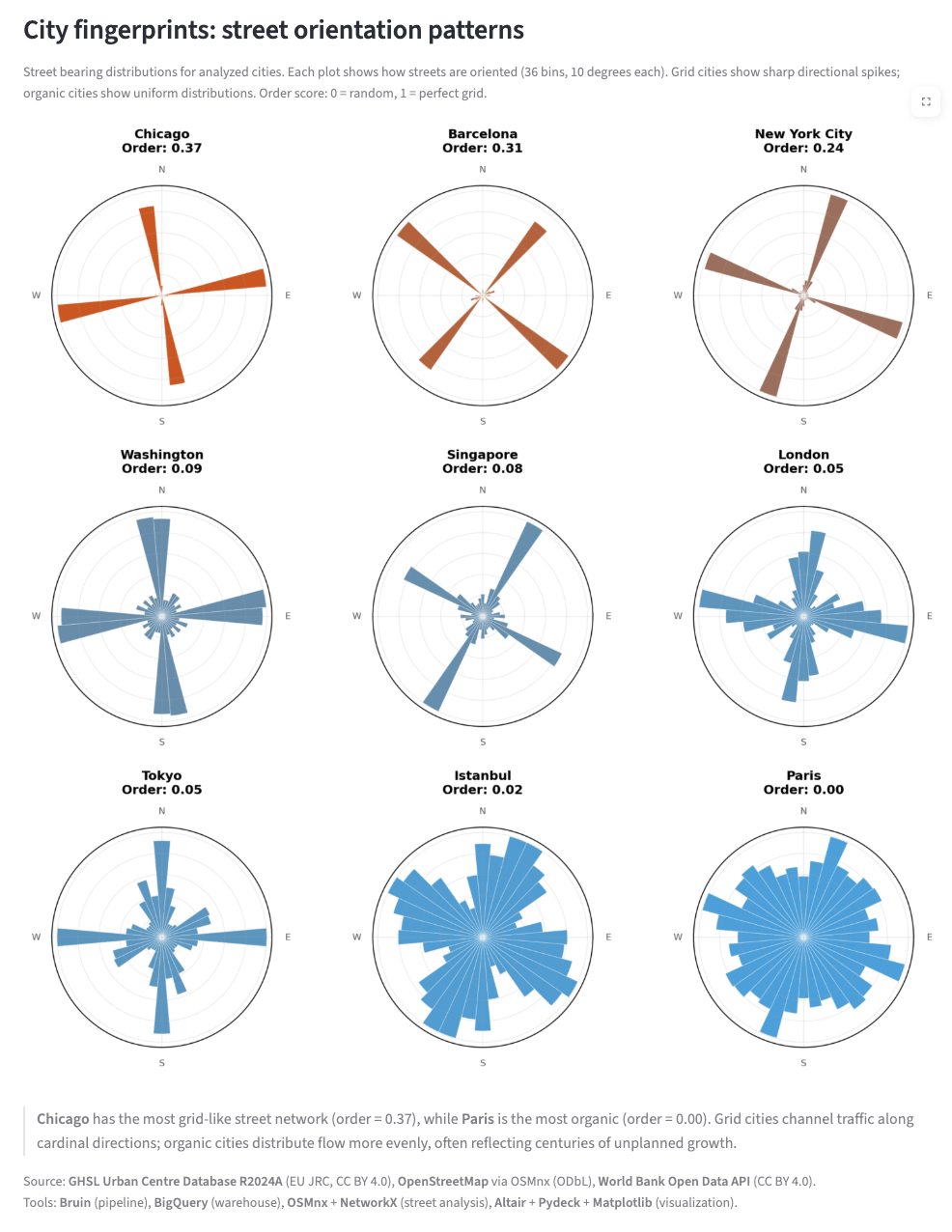
Source: GHSL Urban Centre Database R2024A (EU JRC, CC BY 4.0), OpenStreetMap via OSMnx (ODbL), World Bank Open Data API (CC BY 4.0).
Tools: Bruin (pipeline), BigQuery (warehouse), OSMnx + NetworkX (street analysis), Altair + Pydeck + Matplotlib (visualization).
Posted by uncertainschrodinger

![[OC] Cities' Street Grid Score](https://www.byteseu.com/wp-content/uploads/2026/04/icapijy626vg1-791x1024.png "[OC] Cities’ Street Grid Score")
34 Comments
Source: **GHSL Urban Centre Database R2024A** (EU JRC, CC BY 4.0), **OpenStreetMap** via OSMnx (ODbL), **World Bank Open Data API** (CC BY 4.0).
Tools: **Bruin** (pipeline), **BigQuery** (warehouse), **OSMnx** + **NetworkX** (street analysis), **Altair** + **Pydeck** + **Matplotlib** (visualization).
I’m sure Londoners will disagree, but in this instance I actually think London came out coolest looking
New York: 0.24
Pairis: 0.00
Rome: *EYYYYYYYY!*
In Seattle, two guys argued about what the orientation of the streets should be. Downtown is N-S, but a little north of downtown, you hit the Denny Triangle and the streets orient along the shore (IIRC). If you have a minute and the data, that might be an interesting one to try.
Now I want to see Boston. As a new Yorker, I’m certain it will look like a beach ball because no two Boston streets run parallel because the city was planned by my drunk Irish greatgrandfather.
France: “Ahhh shit. I’m le lost.”
“New York City” appears to be only Manhattan here. Other parts of the city have grids with different alignments.
Having grid-like zones in cities (such as Barcelona’s Ensanche or NYC’s Manhattan) is not inherently bad.
Barcelona is interesting because you can see the Eixample and the main cross and then the smaller cross is Diagonal, a massive road that breaks the grid patter at 45 degrees to the rest of the city!
https://preview.redd.it/t2dn6qt396vg1.jpeg?width=960&format=pjpg&auto=webp&s=85c37d6e165e11609c7afe1e3902807276f83c6f
Some more cities
What is going on with Washington, DC’s slightly off the cardinal direction street orientations? The cardinal directions make sense with DC’s grid and the smaller spikes are the avenues, but the large second angle close to the cardinal directions seems like a data issue.
I’m questioning the scale of the order values a bit. How can Paris be a flat 0.0, if there are still 4 orthogonal directions that have visibly more streets than the other directions? Shouldn’t 0.0 be reserved for a hypothetical place where every road direction appears equally?
Would love if this were an interactive map. Want to test a few cities out
Are these weighted by # of lanes or traffic? Should they?
Please, if you want your city to have an orthogonal grid, made it at 45º, like Barcelona’s. It’s the way every house will have a similar amount of sun.
Surprised London is so gridular here, sure doesn’t feel it. Guess it’s a big ass place and there’s gotta be enough griddy bits to even out
What if a street bends? Like a ring road? Does that make a bunch of little sections of each orientation?
How did you account for the fact that while New York is strongly gridded, it’s not a unified system and there are multiple grids that go in different directions?
Now do Salt Lake! Should get an amazing score!
Can you cross reference their 4 most used directions with their latitude?
the grid score seems kinda fucky, chigago is .37 out of 1? it seems indistinguishable from a 1
Chicago was originally built on a grid in the 1830’s and then rebuilt on the same grid after the Great Fire.
I wonder what kind of a score SLC, UT would get.
Chicago is like when I open Cities Skylines and fill in the entire street grid first
Chicago’s grid is perfectly north south east west oriented. This data is incorrect.
How do you calculate that parameter?
Fyi, that’s not NYC’s. That’s just Manhattan.
This is 100% Manhattan not NYC
It’s incredible that La Plata (Argentina) isn’t listed.
https://preview.redd.it/0t3b8u7ze7vg1.png?width=980&format=png&auto=webp&s=7f7f96d1f0e7b22c110f5aca4ab466f6b73fc8b9
Would be kind of you to credit Geoff Boeing who both developed the methodology and packages you are using to replicate his work…
When I was living in NYC my favorite part of the city was the financial district, because it’s the one that was the easiest to navigate for my Parisian ass.
In the straight avenues I was always confused which avenue I was in. In the random streets between Wall Street and the tip of Manhattan it felt easier. Random streets are more unique and easier to remember for me.
Salt Lake City is probably the most gridded large city, right?
Istanbul would be even closer to Paris if it wasn’t for the 3 major bridges between two continents and the collectors directed towards those + coastal roads along west-east direction.
Chicago should show at least some radial streets toward the west like Milwaukee, Lincoln, Ogden/Rte 66, Grand, Archer. And the two radial Interstates, I-55 and I-90.