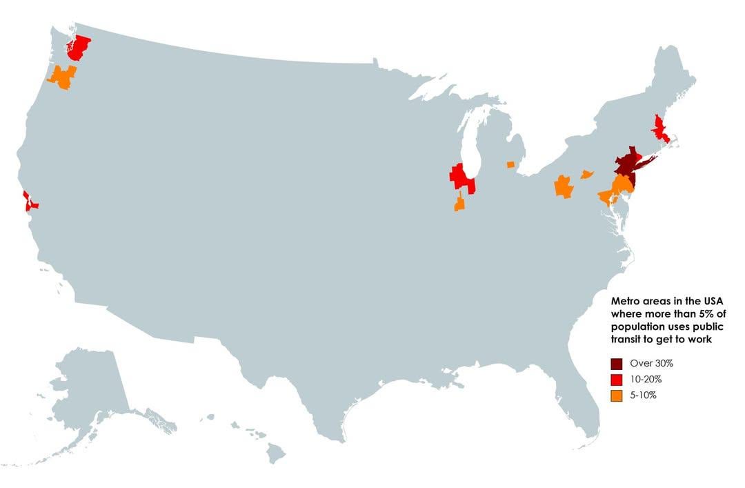
Ann Arbor showing up on these maps will never not be funny to me
Montaigne314 on
Giant wasteland of urban sprawl
Ok_Grape8420 on
Numbers for DC seem inaccurate to me – what’s your data source?
Greedy_Syrup3516 on
Considering how dense and populated both Florida and Texas are, it really shows how strong car culture is in North America.
cobaltjacket on
The number would be higher in Chicagoland, but:
* COVID reduced the number of commuters, and some moved to the suburbs.
* There’s a fair number of people who drive, irrationally, due to some perceived need for control or due to misconceptions about safety (Chicagoland public transit in quite safe overall.)
Dragontastic22 on
I doubt what this map considers “metro areas.” North of Seattle to south of Olympia and out into the forest and mountains? Portland to Corvallis and out nearly to Bend? There’s simply not enough transit infrastructure in many of those more rural areas for more than 5% of the population to take public transit. Including such large areas in with the cities’ transit rates surely skews the data.
Independent-Cow-4070 on
This is not a serious country lmfao
MyPublicFace on
DC where you at?
JustAGuy3772 on
Baltimore > DC area? No way. DC/Northern VA gotta be at least 5%.
petterri on
No data source? No credibility 🚮
Pitiful_Objective682 on
Crazy thing is if you showed this map in the early 1900s, it would be totally the opposite. We had so so many public transit options.
hollyrose_baker on
Always surprised New Orleans isn’t higher. The transit system is pretty good
redstarjedi on
Wow those 30% are all socialists who hate the personal freedom of an automobile. They hate our freedom, and I hope trump does something about it. So they can get a job and buy a car like a good American.
Sadly I know people that actually believe that.
blacknix on
Wait what color is 20-30%?
ToastyBedsheets on
This is quite sad. When my family was on holiday in Switzerland, we did not even bring a car seat. All travel via trains (90%) and busses. Everything was clean, the people were nice, nobody was strung out on drugs or causing a scene. It was wonderful. Although the smoking could be cut back a bit.
Less than 5% of people in Buffalo use public transit to go to work? I take it all the time
neelvk on
I hoped Iowa City would be on the map
yzerman88 on
Los Angeles

WhyAreYallFascists on
God damn look at Portland Metro! I did not know it was *that* big lol. Doesn’t feel like it.
zubie_wanders on
Is the bit south of Chicago Urbana Champaign?
Narrow_Ship_1493 on
I’m curious, do Americans all drive to work, or do they use airplanes more often?
tvtb on
LOL at Atlantic County NJ being colored in. There is a train that goes from Philly to AC, and some busses in AC, but it seems laughable to me to suggest that greater than 5% of people in the whole county are taking them.
esperantisto256 on
Is Northampton PA on this?
maxsimile on
Where’s DC?
Conyan51 on
In all fairness that’s like 60ish% of America’s population.
phoenix823 on
As someone who grew up in the grey but moved to the dark red 25 years ago, it’s really difficult to understate just what a positive impact this has on your life. Even if you own a car.
quothe_the_maven on
There is absolutely no way this map is accurate unless it’s only counting white collar workers.
Riptide360 on
No wonder MAGA doesn’t get it.
dustinpdx on
The “metro area” in Oregon makes no sense at all.
lucasl23 on
By design.
enfly on
Now do EU.
Sophia_Y_T on
Now do europe
[deleted] on
Spent 20 adult years not having to own a car at all, and it was so amazing I decided it’s a requirement for my retirement. 13 years in Manhattan and 7 Hawaii. Quality of life was amazing.
*owned 9 motorcycles in my life so it’s not like I don’t love engines.
Morlock19 on
God thats depressing
bigeasy19 on
Seattle area about to jump up now that the light rail from the eastside finally got finished going over the lake
sgt_oddball_17 on
To get Manhattan in the NY Metro area, you almost have to.


37 Comments
Ann Arbor showing up on these maps will never not be funny to me
Giant wasteland of urban sprawl
Numbers for DC seem inaccurate to me – what’s your data source?
Considering how dense and populated both Florida and Texas are, it really shows how strong car culture is in North America.
The number would be higher in Chicagoland, but:
* COVID reduced the number of commuters, and some moved to the suburbs.
* There’s a fair number of people who drive, irrationally, due to some perceived need for control or due to misconceptions about safety (Chicagoland public transit in quite safe overall.)
I doubt what this map considers “metro areas.” North of Seattle to south of Olympia and out into the forest and mountains? Portland to Corvallis and out nearly to Bend? There’s simply not enough transit infrastructure in many of those more rural areas for more than 5% of the population to take public transit. Including such large areas in with the cities’ transit rates surely skews the data.
This is not a serious country lmfao
DC where you at?
Baltimore > DC area? No way. DC/Northern VA gotta be at least 5%.
No data source? No credibility 🚮
Crazy thing is if you showed this map in the early 1900s, it would be totally the opposite. We had so so many public transit options.
Always surprised New Orleans isn’t higher. The transit system is pretty good
Wow those 30% are all socialists who hate the personal freedom of an automobile. They hate our freedom, and I hope trump does something about it. So they can get a job and buy a car like a good American.
Sadly I know people that actually believe that.
Wait what color is 20-30%?
This is quite sad. When my family was on holiday in Switzerland, we did not even bring a car seat. All travel via trains (90%) and busses. Everything was clean, the people were nice, nobody was strung out on drugs or causing a scene. It was wonderful. Although the smoking could be cut back a bit.
This is a repost from [three years ago](https://www.reddit.com/r/MapPorn/comments/16dyq57/metro_areas_in_the_usa_where_more_than_5_of/), with a couple word changes to the title, and maybe that was a repost from earlier. No data source was cited, but r/MapPorn doesn’t require maps to reflect reality, they just need to meet aesthetic standards.
Less than 5% of people in Buffalo use public transit to go to work? I take it all the time
I hoped Iowa City would be on the map
Los Angeles

God damn look at Portland Metro! I did not know it was *that* big lol. Doesn’t feel like it.
Is the bit south of Chicago Urbana Champaign?
I’m curious, do Americans all drive to work, or do they use airplanes more often?
LOL at Atlantic County NJ being colored in. There is a train that goes from Philly to AC, and some busses in AC, but it seems laughable to me to suggest that greater than 5% of people in the whole county are taking them.
Is Northampton PA on this?
Where’s DC?
In all fairness that’s like 60ish% of America’s population.
As someone who grew up in the grey but moved to the dark red 25 years ago, it’s really difficult to understate just what a positive impact this has on your life. Even if you own a car.
There is absolutely no way this map is accurate unless it’s only counting white collar workers.
No wonder MAGA doesn’t get it.
The “metro area” in Oregon makes no sense at all.
By design.
Now do EU.
Now do europe
Spent 20 adult years not having to own a car at all, and it was so amazing I decided it’s a requirement for my retirement. 13 years in Manhattan and 7 Hawaii. Quality of life was amazing.
*owned 9 motorcycles in my life so it’s not like I don’t love engines.
God thats depressing
Seattle area about to jump up now that the light rail from the eastside finally got finished going over the lake
To get Manhattan in the NY Metro area, you almost have to.