
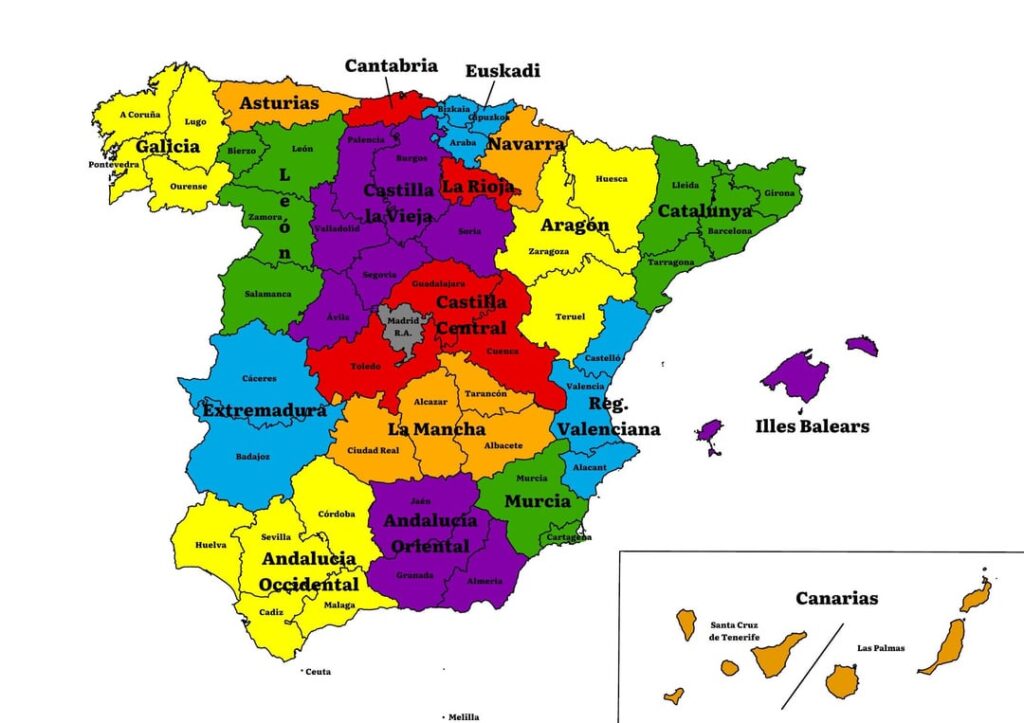
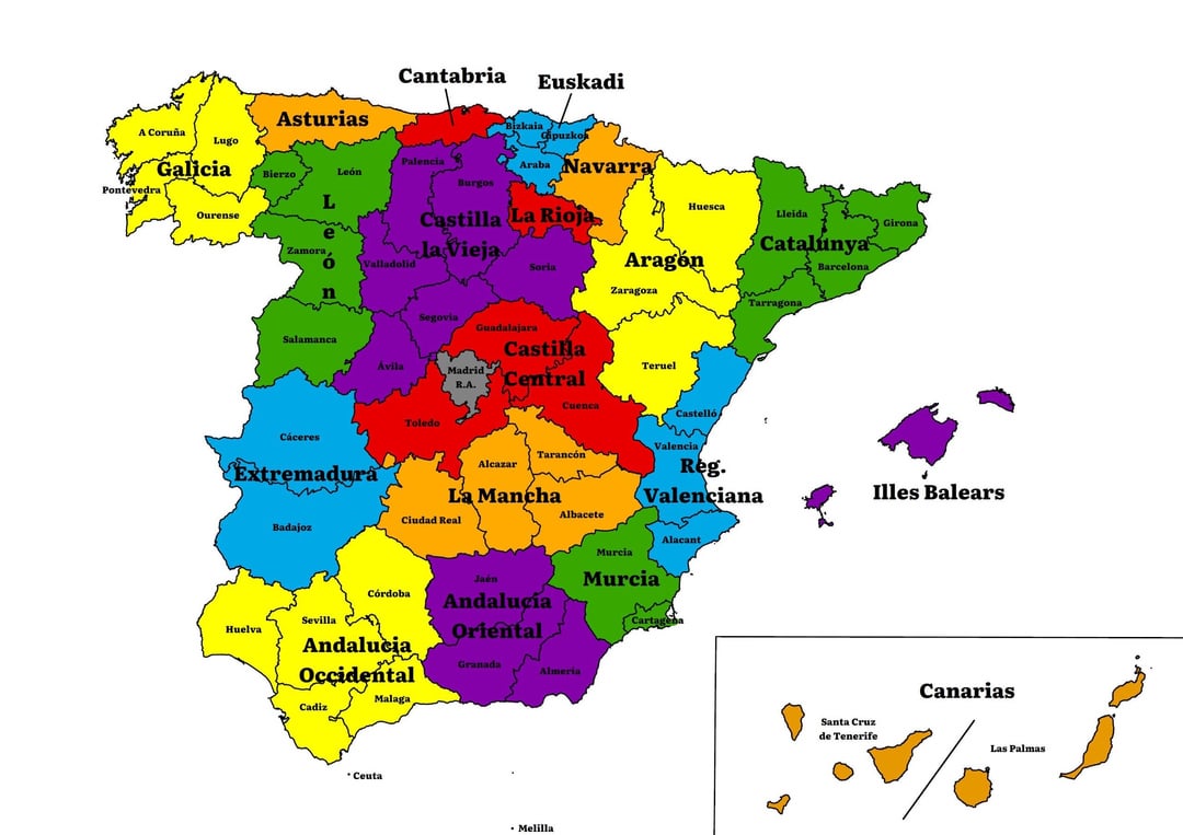
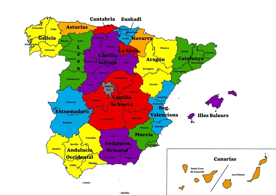
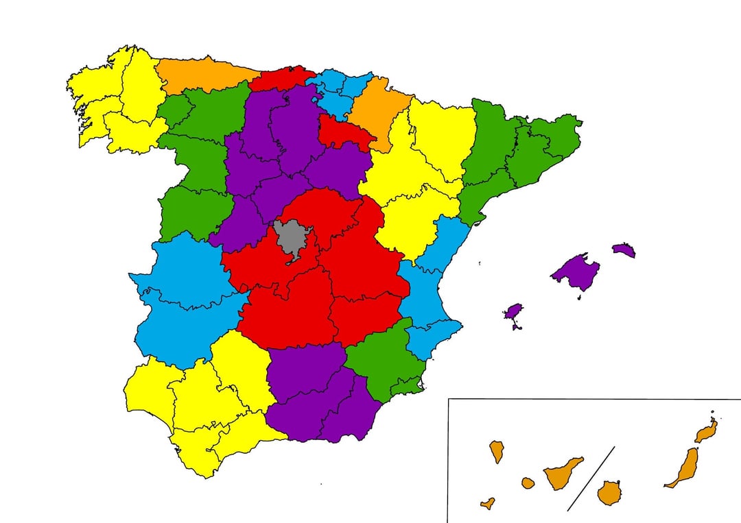
Hello, as a continuation of the post I made yesterday putting a map of Spain with some changes in the current territorial division and asking people their opinion about it, I have made these two maps.
Just like in the previous post, I’m asking you the same question today, so what do you think?
In the same way, one of the main problems that we encountered, beyond which province belongs to such community or to that other, was the current provincial division itself, coming from 1833, and the lack of adjustment of some provinces to the territorial reality.
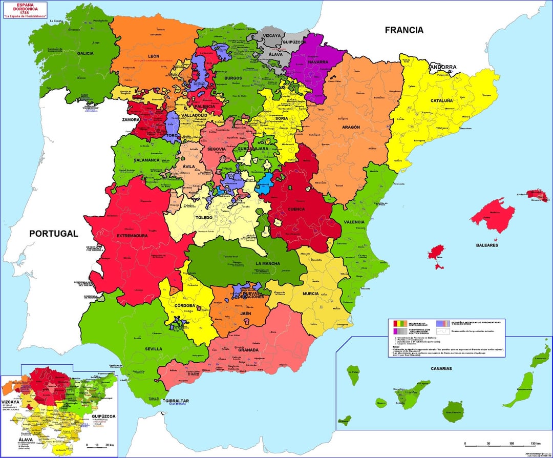
Thus, based on the debate in the comments, the current provincial division (1833), and the map of Floridablanca’s municipalities (1785), I have prepared the attached maps.
The changes I have made have been: – Separation of León as CCAA – Creation of El Bierzo as province of León – Division of Cantabria, annexing the territories of the Campoo-Los Valles region to the province of Palencia. – Splitting of La Rioja de Castilla, forming Old Castilla: Palencia, Burgos, Soria, Valladolid, Segovia and Avila. – Splitting of Albacete from the typically Murcian municipalities of the province, annexing it to the Region of Murcia. – The formation of the urban area of Madrid as an autonomous region/city (based on some studies that I will later cite), annexing the remaining territories of the province of Madrid to the provinces of Guadalajara and Toledo, following as far as possible the model of 1785 by Floridablanca. In this case, the majority of the population remains within the autonomous region, with the other provinces distributing the municipalities with smaller populations, avoiding demographic imbalances. – In Murcia the creation of the province of Cartagena and the annexation of the Vega Baja region (split from Alicante). As well as annexation of the Murcian municipalities of Albacete. – Reduction of exclaves and enclaves (such as the Condado de Treviño that passes to Euskadi or the Rincón de Ademuz that passes to Castilla) – The return of Requena, Utiel and surrounding areas to Castilla. – Division of Andalusia into two, Western and Eastern, responding to demands for differentiation between both regions. – In what was New Castile, total reconfiguration of the provinces adapting the Floridablanca model of 1785 to the current provincial reality.
And what else can be talked about besides Andalusia and Madrid:
On the first map – The Autonomous Community of La Mancha, not only responding to those who claim the region as its own entity, but also providing a solution to the existing problems in Castilla-La Mancha between the provinces of La Mancha and those that are only Castilian . Thus this new CA appears made up of 4 provinces: Ciudad Real (made up of the territories of Ciudad Real, the Almagro District and Campo de Calatrava, with capital in Ciudad Real), Alcazar (made up of the territories controlled by the orders of Santiago and San Juan, as we can still see in the toponymy of the place, with territories of the current Toledo, Ciudad Real and Cuenca, and with capital in Alcazar de San Juan), Albacete (made up of the Castilian territories of the province of Albacete and the Alcaraz District, with capital in Albacete) and Tarancón (made up of the La Mancha territories of the province of Cuenca, differentiated from the mountain area, and with capital in Tarancón) – The Autonomous Community of Central Castilla, made up of Toledo (which has lost La Mancha and has gained the municipalities of Alcarria Madrileña and the foot of the mountains (similar to the division of Floridablanca in 1785), Guadalajara (losing the Señorío de Molina but gaining the municipalities of the east of Madrid and the Sierra North (Guadalajara thus taking a form similar to the one it had in 1785)) and Cuenca (which loses La Mancha but gains the Señorío de Molina and Requena/Utiel (taking a new form, a mixture of my La Mancha reality and the situation with the division of Floridablanca of 1785)). And that responds both to the Castilian part of Castilla-La Mancha and responds to the urban reality of Madrid, surrounding the autonomous region of the capital and forming part of its most remote metropolitan area (as may be the case of Maryland and Virginia for Washington DC in the United States). The only part that is far from this urban reality is the province of Cuenca, limited to the surroundings of the Serranía in general.
In the second map: – The creation of Castilla la Nueva with an important provincial reconfiguration, with Toledo, Guadalajara and Albacete in the same way as the first map; with Cuenca irrigating the part of La Mancha (province of Tarancón on the first map); and with the provinces of Ciudad Real and Alcazar from the first map uniting into one and forming the province of La Mancha.
I know it’s controversial, but that’s the fun of it in a way, being the result of the debate of several people from different parts of Spain and trying to adjust to the history of the territories in a way that is perhaps better than the current territorial division. current.
What has been said, I know that it can give rise to a lot of debate and controversy, so please, there is peace, that everything can be debated with respect and in order to form a better vision of the current territoriality in Spain.
Whoever wants to comment, I will be happy to read and respond, since it is a topic that is of special interest to me, both for its social, historical and geographical implications.
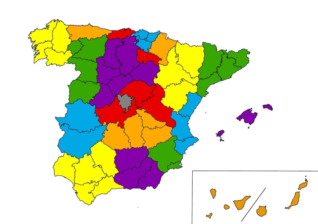
I attach the maps both with and without the toponymy to facilitate the view of the borders between regions. As well as adding the map of Floridablanca from 1785.
As I say, out of respect and curiosity for the subject, I am delighted to read what you think about it.
https://www.reddit.com/gallery/1dj6j9x
Posted by IntroductionShort338
2 Comments
Adjunto las fuentes que he utilizado para establecer la Región Autónoma de la ciudad de Madrid (que por cierto se asemeja en cierta medida igual que sus vecinos, a la forma que tenía en la división de Floridablanca de 1785):
– [https://www.researchgate.net/publication/328923196_El_area_urbana_funcional_de_Madrid_1991-2011_Metodologia_y_resultados_de_una_propuesta_de_delimitacion_y_caracterizacion_multicriterio](https://www.researchgate.net/publication/328923196_El_area_urbana_funcional_de_Madrid_1991-2011_Metodologia_y_resultados_de_una_propuesta_de_delimitacion_y_caracterizacion_multicriterio)
– [https://www.ub.edu/geocrit/sn/sn-420.htm](https://www.ub.edu/geocrit/sn/sn-420.htm)
Para las subdivisiones que he hecho en La Mancha me he basado tanto en la provincia de La Mancha que vemos en Floridablanca en 1785 como en la definición de la región por parte de Madoz en 1848, pero además y sobre todo en el mapa de las ordenes presentes en la región, que adjunto a continuación.
https://preview.redd.it/n3bjbtipnf7d1.jpeg?width=1284&format=pjpg&auto=webp&s=ab1842f6279f5ebeab7b4da2616a58bd5ad39158