

Digitally agile Estonia is well known for implementing many technological solutions that other countries are still struggling with, e.g. secure and unified data exchange system in public sector. This article focuses on Geo3D, the new masterplan for spatial data production and usage for the Estonian public sector, led by the Estonian Land and Spatial Development Board. After implementing the action points, it will result not only in cheaper data production for the mapping agency but also better open data, tools and services for innovative products – such as digital twins and map-based AI systems – in the public and private sectors.
In the early 2020s, several technological advancements (e.g. the rise of GeoAI, and better photogrammetry and Lidar sensors) and ever-decreasing funding from public budgets made it necessary for national mapping agencies in many countries to develop new, futureproof products and ways to continue the production of existing maps and geospatial data. In those pivotal years, the Estonian Land Board (the predecessor of the Estonian Land and Spatial Development Board, ELSDB) spent a considerable share of its internal resources on brainstorming the key areas for its future strategy. The strategy was eventually launched, named Geo3D to underline the importance of 3D data for data-driven decisions in the future.
Creating the strategy
When creating the Geo3D strategy, the following focus areas were identified:
- Modernization of the existing data acquisition platform
- Creating a 3D competence centre that would coordinate the production of 3D data and digital twins in Estonia
- Research and development of GeoAI in various contexts, especially for semi-automated mapping
- Developing a new generation map portal for a unified presentation and integration of 2D and 3D data
Based on these starting points, a comprehensive analysis was carried out in 2023 with the help of Ernst & Young Baltic and Alphagis. More than 20 existing and prospective users were interviewed, their needs analysed, and strategic goals formulated and validated with Estonian and international experts.
New devices for better data
Activities for moving on with implementation of Geo3D started right after finishing the analysis. Getting the strategy formulated on paper was a necessary first step, but not necessarily the biggest hurdle. Problems with acquiring the required financing and reorganization of the agency caused slight delays in the intended schedule. However, the strategy is now being implemented step by step and is inching towards the desired results.
One of the biggest gaps that the strategy document outlined was the need for better data. As the agency responsible for mapping the whole (albeit small) country, the ELSDB had a long history of using airborne sensors to acquire geospatial data. In 2024, new sensors were installed for the aircraft. According to the principles laid out in the Geo3D strategy, a new IGI UrbanMapper 2 EVO aerial camera now provides both nadir and oblique images, and a new RIEGL VQ-1460 Lidar scanner accompanies the images with a dense point cloud. The aircraft used by ELSDB has two apertures, so the camera and Lidar collect data at the same time, making it easy to use both datasets for training AI models.
The first flights with the new devices were completed in spring 2025, when the short window after the snow had melted and before the first leaves appeared on deciduous trees offered the best conditions for aerial mapping flights. The data is still being processed, but the initial datasets look very promising.
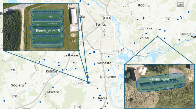
Figure 1: GeoAI in action – detected solar parks near Tartu, Estonia.
GeoAI: the colleague of tomorrow
Automated mapping and feature extraction from aerial imagery has been (and still is) the goal for many mapping companies and agencies around the world. Geo3D formulated it as one of the action points of the strategy that would help the ELSDB to produce maps and geodata more efficiently, especially ensuring shorter renewal cycles for clients. A model for detecting new solar farms was successfully built in-house, but wider scale implementation (e.g. detecting changes in buildings) have not yet been successful.
Ironically, the main obstacle is the effectiveness of human detection, especially for features such as buildings and roads that are abundant in densely populated areas. In areas like Estonia with up-to-date existing map data, the output of the AI algorithm must be of exceptional quality (F-score of at least 0.97-0.98) to be more effective than a human. A lower-grade output just means that the combined approach (machine with human inspection and correction) would result in slower production cycle than using human resources only.
Nevertheless, the ELSDB is continuing research in the field and feels hopeful that the technological advances mean that AI-powered solutions will soon be able to perform the most tedious change detection and digitizing tasks. It is likely that the main responsibilities of cartographers will shift from manual digitization to creating better training data for machine learning algorithms.
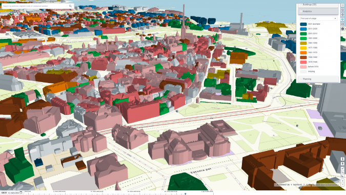
Figure 2: 3D buildings in Tallinn, Estonia, coloured by first year of usage in e-construction 3D digital twin.
3D data production
In 2021, the agency tested and successfully completed the automatic 3D modelling of every building in Estonia using Lidar point clouds and topographical data. In addition to accurate geometry, each model also included attributes and links to national registries. The enthusiasm for and competence with 3D geodata at the ELSDB kept growing, leading in the Geo3D analysis to the strategic goal of becoming the national 3D competence centre. Fast-forward to 2026 and the progress is clearly visible. The ELSDB offers 3D models for several man-made features, including bridges, tunnels, greenhouses and various other constructions, like galleries and wind turbines.
In addition, the agency has taken its first experimental steps to model natural phenomena. Locations and basic parameters – like height, diameter of canopy, deciduous or coniferous tree type – are detected from airborne Lidar point clouds and imagery. Generic 3D models are then used to visualize the result.
All the 3D datasets are published as open data. They have proven interesting and useful for both Estonian and international users, which range from researchers to companies to hobbyists. The new Lidar sensor will undoubtedly boost the geometric accuracy of generated models, and the higher-density point clouds will hopefully help in modelling additional features of the 3D reality, such as for more realistic noise propagation analysis.
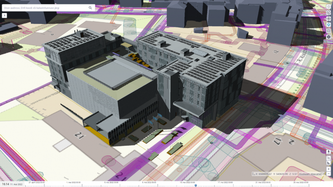
Figure 3: The e-construction 3D digital twin combines many data sources, including a BIM model of planned building work, 3D models of existing buildings, a 2D basemap and a 2D view of underground utility networks.
X-GIS 3D
When the ELSDB was created in 2025, the 3D content creators from ELB and one of the biggest users of the 3D data – the e-construction digital twin – were merged into one team. Their increased collaboration could be felt in the development of the X-GIS 3D platform.
X‑GIS 3D is the code name for a new universal map platform with 2D/3D capabilities, which is being built on decades of experience in creating web map systems with open‑source components at the ELSDB. The user interface will be based on the national design framework called TEDI, to which a map design module is now being added. This module will define the visual appearance and user experience of the map window (e.g. location of address search bar or icons and the behaviour of action buttons).
The web map design that X-GIS 3D implements will let users display either 2D or 3D data, or optionally enjoy both views in parallel. Basic data editing and filtering will be included as well, with the possibility of adding more complex behaviour later. Besides the smart user interface, X-GIS 3D will also include a modern cloud-based backstage, serving geospatial data to front-end web users and also to other systems needing map data.
The launch of X‑GIS 3D and its first use cases at the ELSDB is planned for 2027. The source code will be released under a permissive licence afterwards. The longer-term goal is to apply the TEDI design for all public-sector information systems that need a map window. This will create an opportunity to reduce development and licensing costs and also provide a unified user experience across numerous systems.
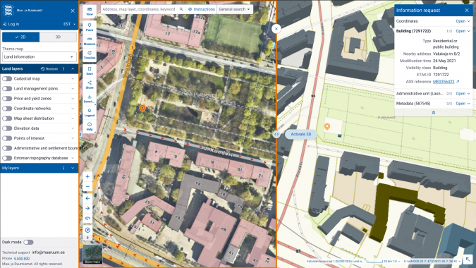
Figure 4: X-GIS 3D showing 2D and 3D view in parallel.
Towards the future
Recognizing the need to stay up to date with the changing technological and organizational demands, in 2026 the ELSDB will create a new institutional strategy document that will include and amend other strategies, like Geo3D. The new strategy will define a single computing platform that brings all of the ELSDB’s currently separate solutions (land cadastre and other registries) together into one coherent and cloud-based system, orchestrating numerous services with the help of X-GIS 3D. As for data production, even more focus will be put on (semi)automatic mapping to provide up-to-date maps. These major steps, along with many more minor ones, will improve public services within and outside of the ELSDB.
About the ELSDB
The Estonian Land and Spatial Development Board (ELSDB), the country’s national mapping and cadastral agency, was founded on 1 January 2025 by merging the former Estonian Land Board with several other governmental organizations and adding new responsibilities. Today, the ELSDB is the competence centre for all land-related activities in Estonia: strategic spatial planning (development of uniform policy and information systems for planning), spatial data (from geodetical networks to national registries), land use and management (including land cadastre) and land improvement (coordinating and ensuring the functioning of land improvement systems). It is a government agency which is funded from state budget, providing data and services to other public-sector organizations as well as to businesses and citizens. The ELSDB’s responsibilities span the administrative sector of four ministries: Economic Affairs and Communications, Climate, Regional Affairs and Agriculture, and Culture.
Further reading
Estonian Land and Spatial Development Board: https://maaruum.ee/en
Geo3D business analysis: https://geoportaal.maaruum.ee/eng/spatial-data/geo3d/geo3d-business-analysis-p928.html
3D digital twin of the e-construction platform: https://livekluster.ehr.ee/ui/ehr/v1/3d
TEDI design framework (in Estonian): https://tedi.ee/