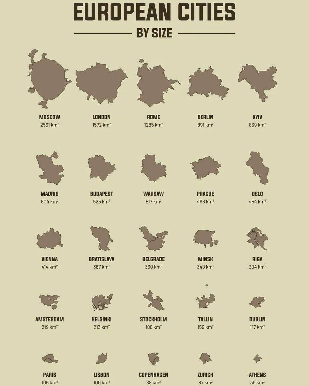
The standard issue with this kind of map is that it uses the administrative borders of the city, instead of the shape of the actual urban sprawl, which would make much more sense
SuperSnowflake3877 on
No Paris?
No-Brief-347 on
That’s not Oslo though thats the municipality. The city itself is just the 15 districts + city centre
Emotional_Fan239 on
When I think of Berlin I imagine it much smaller, like Madrid sized
sexy_snake_229xXx on
No Istanbul?
Finn_on_reddit on
Athens is packed full!
Western-Edge-965 on
Is there an explanation for the dog legs on Moscow?
RoelBever on
Why not Bern but Zurich?
bitavk on
What is the criteria for making the list? There are lots of cities with bigger surface area than listed here… Capitals? Nope… Biggest populations? Nope… EU members? Nope…
Latubu on
Greater London is a recent phenomenon and includes many boroughs that was never considered part of London.
madmonkey23 on
And Bucharest? Much bigger than Budapest!
Brother we did the Hungarians dirty, who is the bigger power now. Bucharest power!!!
opinionated-dick on
This is nonsense. Area as a measure of city size is meaningless.
By this metric only 6 European capitals would be larger than Leeds
Grzechoooo on
I like how Warsaw is roughly the shape of pre-fragmentation Poland.
Material_Skin_3166 on
Is Brussels missing?
Remarkable_Ad9193 on
HELSINKI IS BIGGER THAN STOCKHOLM!!!! 🇫🇮🇫🇮🇫🇮🇫🇮☝🏻☝🏻🗿
TheIcebeard on
Athens is wrong
Areedvi on
St. Petersburg? Isn’t it the third in the list by that logic?
No_Peach2280 on
That’s a map of Greater London which is essentially a county comprising two cities (City of London, and City of Westminster) alongside the 32 boroughs. In the UK, Greater London as pictured is more comparable to a county such as Leicestershire. The actual City of London is the smallest in the UK.
Kikelt on
This looks like just the administrative limit for some… and metropolitan for others.
Your_Friendly_Nerd on
Would be interesting to see population density in the same graph
andrewbaidoo on
Wrong title. Should be European capitals by size.
kinkade on
This orange is bigger than that apple
JetlinerDiner on
Again this shit map? What are the mods doing, seriously!
BreakfastQuirky6783 on
You missed Sofia,Bulgaria
MountainTank1918 on
Bro, Tbilisi is 504.3 km2, metro is 726km2, why you excluded it.
Apatride on
Where is Brussels?
stoutymcstoutface on
*by area according to semi randomly drawn administrative boundaries*
Edit: maybe I’m old but not sure why it’s not in italics above
Agile-Control-4718 on
Where is Vilnius ?
MilkImpossible4192 on
now by people
dat w matter s
sinusis on
But Moscow is now much larger in terms of territory…


31 Comments
The standard issue with this kind of map is that it uses the administrative borders of the city, instead of the shape of the actual urban sprawl, which would make much more sense
No Paris?
That’s not Oslo though thats the municipality. The city itself is just the 15 districts + city centre
When I think of Berlin I imagine it much smaller, like Madrid sized
No Istanbul?
Athens is packed full!
Is there an explanation for the dog legs on Moscow?
Why not Bern but Zurich?
What is the criteria for making the list? There are lots of cities with bigger surface area than listed here… Capitals? Nope… Biggest populations? Nope… EU members? Nope…
Greater London is a recent phenomenon and includes many boroughs that was never considered part of London.
And Bucharest? Much bigger than Budapest!
Brother we did the Hungarians dirty, who is the bigger power now. Bucharest power!!!
This is nonsense. Area as a measure of city size is meaningless.
By this metric only 6 European capitals would be larger than Leeds
I like how Warsaw is roughly the shape of pre-fragmentation Poland.
Is Brussels missing?
HELSINKI IS BIGGER THAN STOCKHOLM!!!! 🇫🇮🇫🇮🇫🇮🇫🇮☝🏻☝🏻🗿
Athens is wrong
St. Petersburg? Isn’t it the third in the list by that logic?
That’s a map of Greater London which is essentially a county comprising two cities (City of London, and City of Westminster) alongside the 32 boroughs. In the UK, Greater London as pictured is more comparable to a county such as Leicestershire. The actual City of London is the smallest in the UK.
This looks like just the administrative limit for some… and metropolitan for others.
Would be interesting to see population density in the same graph
Wrong title. Should be European capitals by size.
This orange is bigger than that apple
Again this shit map? What are the mods doing, seriously!
You missed Sofia,Bulgaria
Bro, Tbilisi is 504.3 km2, metro is 726km2, why you excluded it.
Where is Brussels?
*by area according to semi randomly drawn administrative boundaries*
Edit: maybe I’m old but not sure why it’s not in italics above
Where is Vilnius ?
now by people
dat w matter s
But Moscow is now much larger in terms of territory…
Where is Bucharest at 240 km2?