

This series is fun 🙂
I've had a couple requests for doing Italy, so here it is! Little disappointed by how normal it looks, but hey, that's still interesting!
Other maps in this series:
UK: https://www.reddit.com/r/MapPorn/comments/1tnc7g2/british_population_visualised/
Germany: https://www.reddit.com/r/MapPorn/comments/1tmchnh/german_population_visualised/
Netherlands: https://www.reddit.com/r/MapPorn/comments/1pg6uu8/dutch_population_visualised/
Posted by KaleyTheKing
36 Comments
Wow, that’s actually a pretty even population distribution relative to the actual shape of the country.
Wow, cool map just look at the northern part looks like a mushroom 🍄 , mario?
Next france please
OP please keep ‘em coming these maps are incredible!
Great map. I’m surprised to see Florence smaller than Bologna. It certainly is huge from a cultural perspective.
How about Poland, Ukraine, Russia?🙂
Would love to see you do Sweden! The northern half is sparsely populated.
China next pls 🙂
Your Maps are incredible, please keep them coming.
Also can you do Denmark
Great maps but I have to be honest. I first thought they were Crosstitch patterns.
Türkiye please!
PLEASEEEEE do TURKEY. I just want to see an absurd Istanbul 😃
Marmara region (2nd smallest region of Turkey out of 7) contains more than 30% of the population of the country.
Il Molise non esiste
Did not realize Rome is soooo much bigger than Milan. Great work!
Do Czechia next!
These maps are great, it’s really interesting how this is fairly even and real in shape compared to the incredibly deformed UK one
Nice! I miss the San Marino hole. 😅
Why is Molise even its own province
Gotta love these.
I love how the map looks like something from world box
Overall balanced, but Lombardy is a beast. I wonder if it’ll become more unbalanced over time due to demographics.
Any chance for Bulgaria down the line?
France will look bizarre I’m sure, much less even distribution
Can you chuck Japan into the pipeline too?
for the cities, you chose those ones based on what?
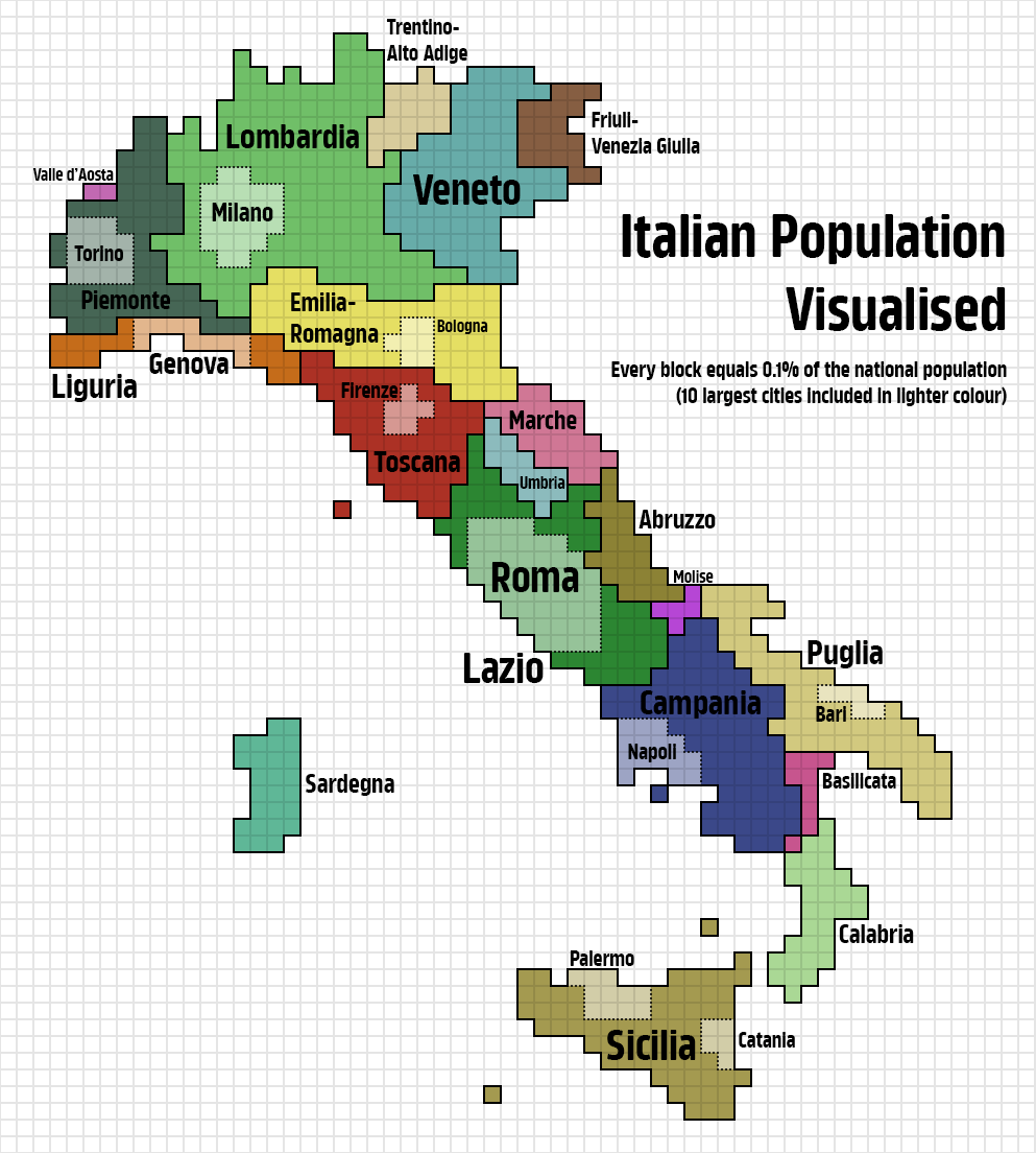
For anyone wondering what the four dots in the sea are, from north to south:
Tuscan Archipelago: most of the population by far lives on Elba, which is the 3rd largest island of Italy after Sicily and Sardinia. Population of Elba is 31,592 while there are 34,389 inhabitants in the whole archipelago.
Campanian Archipelago: the largest island by size and population is Ischia, the 8th largest island of Italy, which has 62,027 inhabitants. Capri has a population of 12,903 and Procida has 10,596.
Aeolian Islands: most of the population lives on Lipari, Italy’s 9th largest island which has 12,793 residents. The entire archipelago has a population of 15,419.
Pantelleria: this island is Italy’s 5th largest, and it has a population of 7,335. I assume the even more southerly and similarly remote Pelagian Islands of Lampedusa and Linosa are also included in this dot; they have a population of 6,462.
Wait wait wait there are a thousand blocks in this image?
Do the Vatican next (one square pixel)
this map would make my great uncles from basilicata go insane
Except for small Piedmont, Umbria, and Sardinia and big Lombardy, every other region is quite proportionate. That’s unsurprising given how evenly populated the whole country is.
Rome is bigger than I expected
Belgium!
Are italians racist towards different italians? Like do they look down on sicilians in the north?
….. I gotta see Australia now, that one is gonna be WILD.
Bellissimo

each block is 1%, not 0.1% of the population, right?
Just a suggestion, could you put a key where you comfirm what total pop. number is in each square? I know it’s a percentage, but would just be interesting to have a perspective on the total numbers too, gives additional insight into what a popular city means for each country.
I thought it was a vacum cleaner house’s mapping 😅