

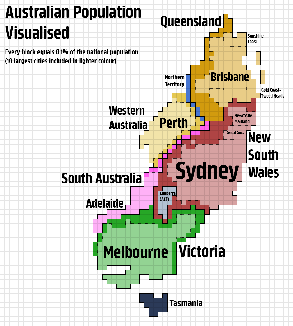
So, I think we were all a little disappointed by how normal the Italy map looked, so I thought I'd treat y'all to the biggest abomination I've made in this project thus far 😀
Goddang, Australia, why did you have to be like this, this was so difficult to make… Anyway, hope y'all enjoy!
Posted by KaleyTheKing
40 Comments
Australia: five city-states pretending to be a continent.
I accidentally squished it, sorry 🙁
You’ve been doing a really good job with these maps!
Who sar on it?
I vote for Argentina next!
Can u do canada?
I don’t like this one, why does Perth need to be so far up north?
Australigascar
Population density so skewed it became Madagascar
A visualisation of urbanisation
What’s the next country you’re gonna do? Japan?
Is this all by you? How much work does it take?
Do New Zealand?
This makes it look like Adelaide borders Victoria and NSW which it doesn’t.
Don’t worry OP, I know it’s because of the state borders.
Only Tassie looks remotely correct shaped
This one makes me a bit queasy
I’m really enjoying this series!
Probably wildest so far
Tasmania has more peopel thank I thought!
These are amazing. Would you do Ireland?
Make one of Brazil.
Please do Romania !
Just curious if Lake Macquarie was grouped in with Newcastle/Maitland?
Australia looks like someone has flipped new caledonia by 90 degree
Love how normally on these maps you can still see the rough shape of the country but Australia is just totally deformed lol
Would be really interested to see New Zealand!
I wait for Poland! and whole world map too
This is an awful map
Are the islands part of Brisbane?
Tried to do[ the same for France](https://imgur.com/a/C4TKtBu). Can’t wait to have your version of it.
Try chile. It will be a very distorted line
Australia is the least city-state shaped city-state
I’ve said this many times before about the population spread of Australia. Imagine the US’s only major population bases were the northeast corridor, and Los Angeles. That’d basically be how Australia’s population spread is like, and even then, what Australia has would be roughly a third of the US example I gave.
Mexico, Brazil, Russia and Colombia would all be interesting. Honestly most countries would.
Chile would no longer be long, as one metro area has 40% of the country. Argentina would also look odd.
As a lurking American, I was surprised to see how large Brisbane is
The Croweater Tendril…
Where’s Jervis Bay?
Genuinely the most ridiculous thing. So glad I caught this post in my feed!
Darwins doing all it can. xD
Thank you !!!
Wouldnt it be best to have the border of South Australia / Northern Territory against Victoria/ NSW / Queensland as the starting point? As a Perth-ling, having SA/Adelaide more west than WA is outrageous. Seeing as the east coast is generally distorted, it would be a better anchor point than…..Melbourne, as it appears????