
I remember back in the day Where is the bus? app. UI/UX needed improvements in my opinion, but the idea was good.
Now I have free time. I am a (geo)developer myself, and with today’s AI, one-man shipping can be done much easier, so I finally did my idea from 6-7 years ago, as a side project and to supplement myself.
I made a public transport app called What? Where?
Available on both iOS and Google Play: https://www.miskuhu.ee/sticker
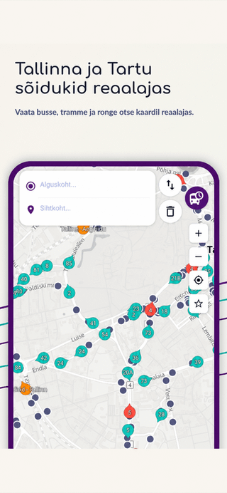
The goal is quite simple: you open the app and quickly understand when the next bus, tram or train is coming and how to get there. I also used the RAPTOR algorithm in the route planner. It can continuously supplement the journey planner with real-time data. Does not use an external service.
Tallinn City Transport also liked my choice of vehicle design. In the spring, they changed the vehicle icons into mummies and used the colors of public transport, almost. The trams did turn Elron orange 😀
The real-time data is updated approximately every 5 seconds and the focus is currently on Tallinn and Tartu. For other locations, I recommend good old peatus.ee or Google Maps. Their guide is generally the best anyway.
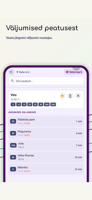
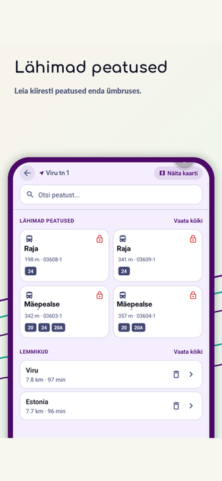
In the app you can see:
- buses, trams and trains on the map in real time
- the following exits of the stops
- next stops and schedule for a specific vehicle
- route search
The app also collects information about the use of stops. I thought that maybe I could make interesting statistics and analytics based on this later: which origin-destination matrices stand out, which stops are disproportionately popular, etc. Such topics are simply interesting.
Subscriptioni making it was purely a hand exercise and does not interfere with the basic functionalities. I wanted to try out the whole process that goes along with the app publishing and payment system.
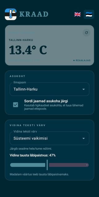
Another small application, Kraad, is for viewing the measured current temperature from the nearest weather station in Estonia.
In the spring, it was constantly viewed from the point of view of children: what to wear. They asked it themselves all the time. Almost all weather apps and widgets show a model forecast calculated the night before. In the spring we had a difference of 5+ degrees here in places between the model and the actual measurement.
Android: Degree Google Play
iOS: Degree App Store
As a side topic: if anyone has an idea for an exciting (geo) application that they would like or could use, feel free to let us know. If the idea is interesting and exciting to do yourself, then maybe you can do it. Monetizationit I’m not chasing. I just want to do something.
https://www.reddit.com/gallery/1tsu9gs
Posted by infectYO
7 Comments
Mul on niimoodi, et peatus mida ma kõige rohkem kasutan ei mahu lähima 10 peatuse hulka, kui ma kodus olen. Maakonnaliinide peatused on lähemal, kus väljumised on väga hõredad ja mida ma kunagi ei kasuta.
See loogika, et kuidas kõige relevantsemaid väljumisi kuvada peaks natuke parem olema kui lihtsalt lähimad peatused ja neist varasemaid väljumised.
Pigem peaks see sorting order olema midagi sellist, mis vaatab rohkemaid peatuseid, mis on läheduses ja sorteerib väljumised selle järgi, et mitme minuti pärast ma enda asukohast liikuma peaksin hakkama, et sellele veel jõuda.
Aga muidu väga lahe, et sellise asja teinud oled. Lihtsalt hea kasutajakogemus sõltub palju sellest, et kas oled transpordisõlme lähedal või kuskil suburbias, kus ongi läheduses ainult üks peatus.
Miks mitte tallinn.transport.ee ? Mida see äpp teeb paremini?
Tundub et iga kuu üritab keegi siin bussigraafikutest rakendust treida
Kas sa eeldad nende asukohta graafiku järgi, või kuidas see käib?
Endal pole vaja, aga tubli et asjatad ja teed midagi. Ui tundub ilus.
google maps ja gis.ee ei toimi?
Lahe. Aga mul tegelt rohkem vaja sellist äppi mis näitab millised kohad bussis vabad on, et ma saan juba enne bussi saabumist ennast seal istumas ette kujutada.