

This map always breaks my heart.
text from map:
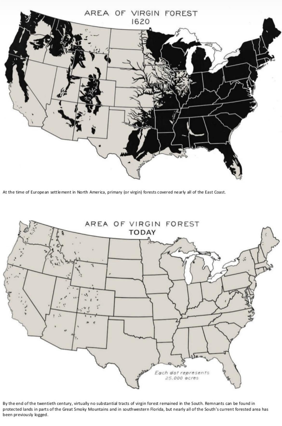
AREA OF VIRGIN FOREST 1620
At the time of European settlement in North America, primary (or virgin) forests covered nearly all of the East Coast.
AREA OF VIRGIN FOREST TODAY
Each dot represents 25.000 acres
By the end of the twentieth century, virtually no substantial tracts of virgin forest remained in the South. Remnants can be found in protected lands in parts of the Great Smoky Mountains and in southwestern Florida, but nearly all of the South's current forested area has been previously logged.
EDIT: for those thinking this is AI generated slop (I will *never* post anything AI generated, I’ve never used it in my life) this is the source of the original map:
This map of the area of virgin forest in 1620 was compiled by William B. Greeley, who was chief of the U.S. Forest Service from 1920 to 1928, in his 1925 article, The Relation of Geography to Timber Supply (Economic Geography, Vol. 1, No. 1, pp. 1 – 14).
EDIT TWO: apparently, the guy who made the original map was a POS and, according to u/cream_puffs_ “Teddy Roosevelt wanted to protect nature, this guy got appointed, this guy sold out the forests. A lot of the West got chopped down because regulators were in bed with industry. If you want a tome of a book to explain it all read The Ghost Forest.”
So yeah, that would explain the dearth of West Coast forests in the top map 😑
Posted by catshifturr
44 Comments
Missed some spots. Would make great land for a beautiful data center.
What did you do to Michigan’s UP and Lake Superior?
EDIT: okay I missed “Virgin”
Did they like fuck all of the trees? Like virgin forest is a stupid term
Misses by far and away the largest swaths of old growth in WA – the Olympic peninsula. Edit: There should also be a couple of dots just south representing the remaining “long corners” in the Willapa hills (SW WA).
Sort of weird to imply that indigenous peoples weren’t doing controlled burns, practicing agriculture and food forests, or just generally having an impact on the land they were living on
Not an accurate map 🙄
Holy shit! We drained Lake Superior and flooded the upper peninsula in 400 years.
How are they defining “virgin” forest? I know for a fact that WA is much more saturated than the map shows. However, if an area is remote AF but the presence of a logging road or a fire lookout station negates the “virgin” aspect, then of course there will be barely any virgin forest left.
Edit: looks like they mean original old growth trees. Well, the 19th and first half of the 20th centuries were brutal for logging. At least in the PNW, most of that has been replanted. You won’t find any 500 year-old trees, but it’s not uncommon to be in areas with evergreen trees as far as the eye can see.
kisatche?
This isn’t remotely accurate for 1620 on the west coast
I’m sorry, how exactly are we defining “virgin forest”?
Yea this seems massively inaccurate.
What caused that weird crescent gap in Mississippi and Alabama?
Thank God we got rid of all that haunted forest
I know Southern California has forests in the Mountains, so why aren’t they shown in either map ?
Is there really no virgin forest land in the Olympic Peninsula in Washington state? There’s a ton of old growth forests there so I guess I’m confused by the meaning of the two terms.
People don’t really seem to get the “virgin” part of this? Regardless of any l inaccuracies in the map, the truth is almost all of North Americas original forests have been logged or otherwise destroyed since Europeans arrived. What is now in its place are secondary-growth forests, development, and plantations often consisting of monocultures.
I’m wondering what that crescent area that’s covering Mississippi and Alabama is.
my bad yall
Keyword is “virgin” forest. European diseases killed most of the Native Americans by 1620. De Soto’s 1540s expedition to Mississippi River shown highly populated area.
A hundred years later they’re all dead. Hence there’s a post apocalyptic “virgin” forest.
This is misleading.
It’s a matter of perspective: to a German, the forests in the U.S.—especially in the Rockies and west of them—feel like untouched wilderness. In Germany, most forests are planted for commercial logging; the forest floor looks as if it’s been swept clean, and even the trees stand in neat rows.
Why is Moosehead lake in Maine the only lake shown as a gap in the forest for the 1620 map? There’s other similarly sized lakes that don’t get shown at all.
This is not accurate. The Pacific northwest is famously covered in forests, as is the deep south and North east
This map is a bit dodgy but Americans did chop down a lot of trees, however America is actually planting more trees than they cut down so forests are growing so it’s not like we just destroyed the land. We actually have more trees than we did a century ago which is amazing. It’s never gonna be the same because well, Americans live on that land now, but some growth is better than no growth
86 virgins
Ah yes. The California Nevada border.
Drawn exactly along the cleanly angled edge of the Sierra’s virgin forest boundary.
I guess the optimist’s view is that we’ve really done a great job creating all those artificial forests in the Great Basin.
I also wonder what the Nevada forest near Zion did to regain its virginity.
Quagmire
Who the hell is fucking the forests?
But in the logging country of the Pacific Northwest, they have been blaming “environmentalists” for their depressed economy for 40 years. If cutting down 95% of the old growth trees didn’t bring you economic security, I don’t think cutting down the last 5% will do the trick.
Now all we have are slutty forests I guess
What the hell is a “virgin forest?” Land that hasn’t been touched, ever?
Bs
Note that 1620 was after 90% of the Native American population died off and their farmland and villages were reclaimed by forest. So only virgin in the sense that it Europeans decided it was always there.
Crazy how they were able to map this in 1620
When the British and French to a lesser extent colonized North America, one of the primary reasons was to source lumber.
So we have slutty forests now?
It’s weird because humans are primates so we should have been able to build cool forest treetop cities. Instead we have suburbia.
Look at all those profits.
Not saying your wrong, but there are large western wilderness areas that do not seem to be consistent with your map, for example the Beartooth-Absaroka and Bob Marshall/Scapegoat/Great Bear in Montana, which are also adjacent to Yellowstone and Glacier, respectively. Those are multimillion acre swaths of timber.
Sorry guys I’ve been fucking like a LOT of trees
Ngl, I don’t trust the reliabiltiy of this map. I’d like to see a new one not made 100 years ago, which is more clear with how it’s defining its parameters.
Now it’s all slightly fucked forests