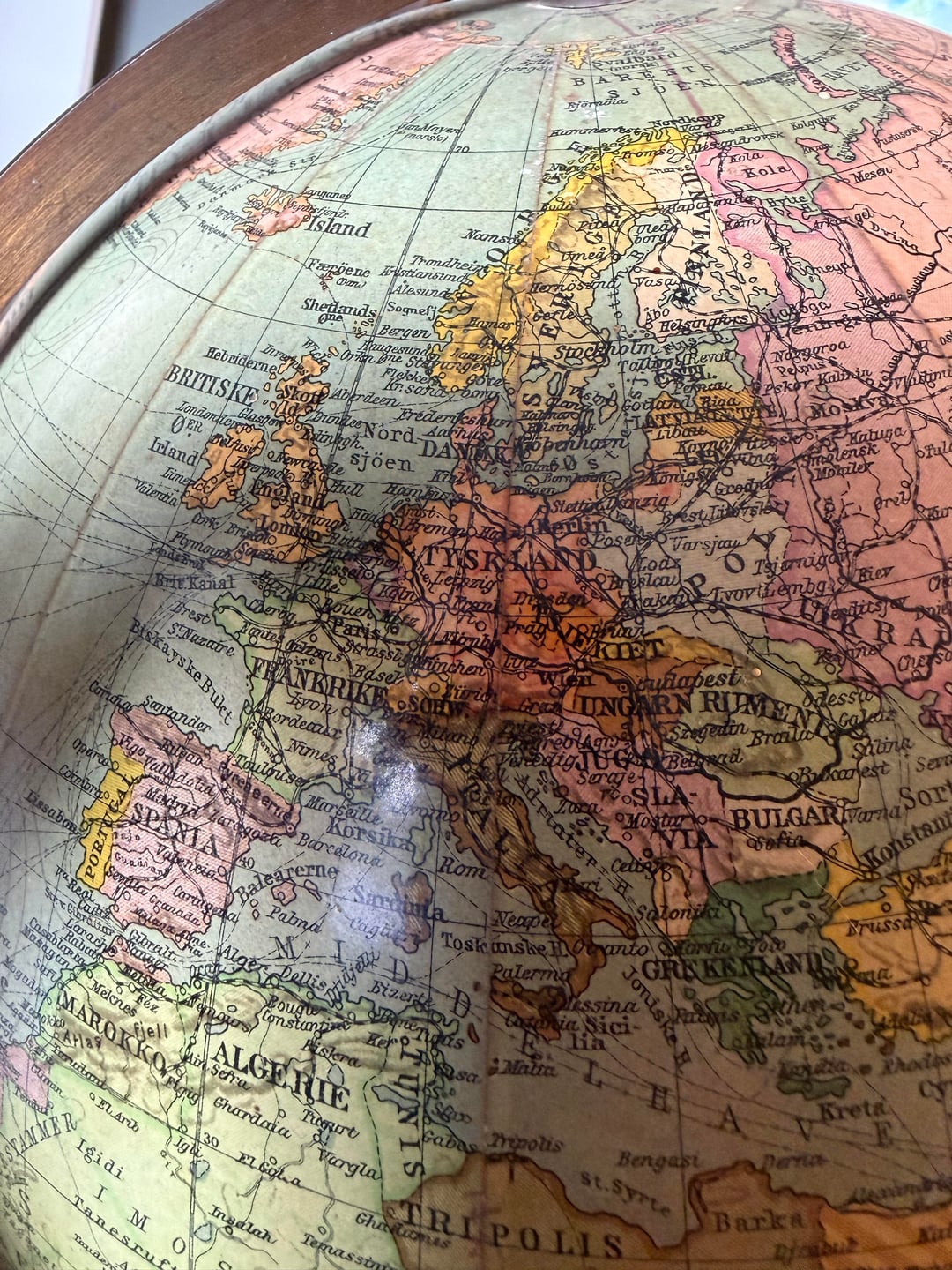
1938 – Austria and Sudetenland are German, but not Bohemia-Moravia
cole_red on
I mean I’ll take it out to a nice dinner but no promises
AccordingRegret8932 on
You might need to show some more, atm all I can say it’s a pre WW2 globe
Dominoe_z on
It’s a globe made during the inter-war period (pre-WW2)
_masssk_ on
Before 1939 – Lvov/Lviv is still Poland. After the ww2 started Soviets took it from Poland and join to Ukraine
ubermensch1001 on
1939 right before the start of WW2. Austria and sudentenland are part of greater Germany. Finland’s pre winter war with Karelia. Poland’s borders, etc.
Extreme-Shopping74 on
I don’t know why the other comments are trying to fail so desperate but Germany becoming larger is basic map knowledge.
12th March 1938 (Germany annexing/retaking Austria) – 2nd November 1938 (Hungary is awarded southern Slovakia)
RingGiver on
I’ll date this globe as long as it pays for dinner.
After-Trifle-1437 on
* USSR exists – Before 1991, but after 1917
* Germany has pre-WW2 Borders – Before 1945 or 39 (depending on wheter the annexations were included by the globe-makers)
* Austria Hungary gone – After 1918 (After 1920 because of Trianon)
* Türkiye exists – After 1923 (Turkish Republic was established)
* Austria Part of Germany – After 13 March 1938
* Sudetenland Part of Germany – After 10 October 1938, however the protectorate of Bohema and Moravia was established on 16 March 1939.
So my best guess is that this globe was made between **Oct. 10th, 1938 and March 16th, 1939**.
SharkeyGeorge on
I can’t, I’m married.
cronktilten on
Riiiiiight before the invasion of Poland
RedLemonSlice on
You can see the city of Gdansk on that globe. When this globe was made this city was just about to suddenly grow in importance
hernandezhero on
Ireland is not partitioned so possibly before 1923
Between 1918 and 1939.
That’s what Poland looked like between those dates.
Jaded-Author9380 on
Also Finland has parts it lost is Moscow treaty in 1940. So it is definitely pre Winter War which began November 30th 1939.
ComplexRecover8199 on
1920-1922
Die UDSSR existiert (1917) noch ohne die Baltischen Republiken (1940) . Irland gehört noch zu den Briten (1922) Deutschland hatte schon die Ostpreußische Enclave (1920)
enguldrav on
Finland is independent, and Karelia and Petsamo are still part of Finland on the map 1917 to 1944
Rolling-Pigeon94 on
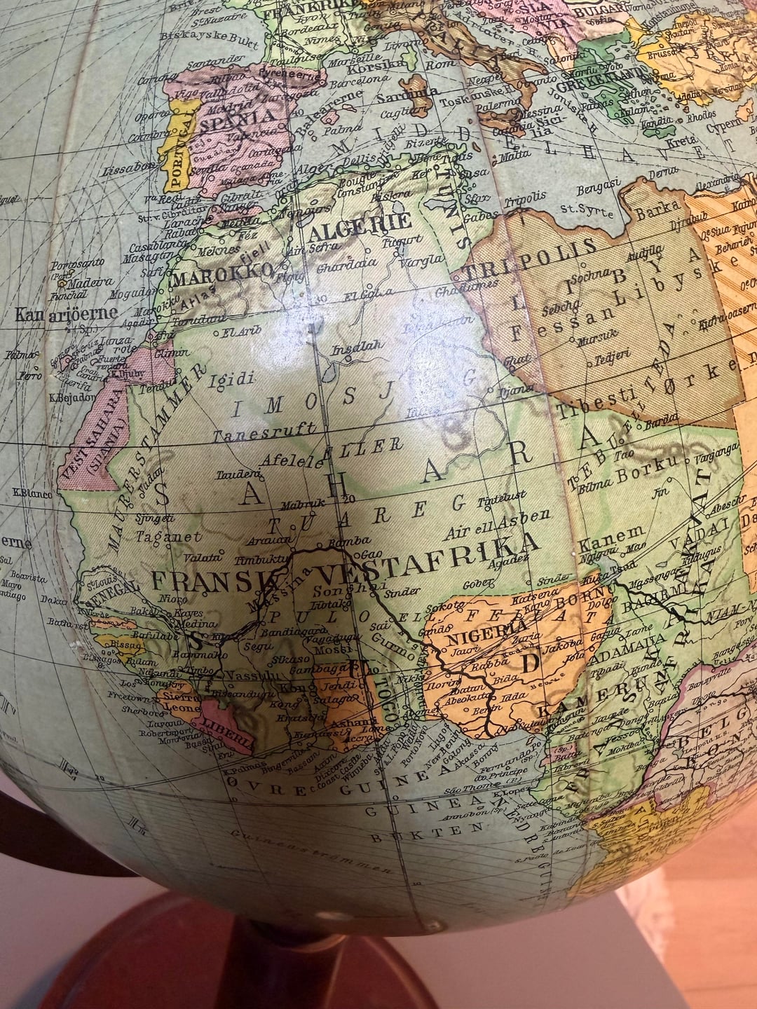
Due to the boarders shown in Africa, I’d say from the 1920s or 30s.
Spiritual-Hamster212 on
No thanks, I don’t need a girlfriend.
Cultural_Main_3286 on
The conversation would be ackward at best and she’d keep rolling off the bed. She’s also too old for you.
Nick_from_Yuma on
my mom says I can only date other globes from my country
lndlml on
Between 1938 and 1945.
1. Austria being incorporated into Germany. On your photo Austria doesn’t appear as a separate country. That would suggest after the Anschluss (March 1938).
2. The second strongest clue is Königsberg still being German which means before 1945.
Haestein_the_Naughty on
We have that exact same globe at home too (also Norwegian) that my great-great uncle got, it’s about 1938-1939
D0M2OO0 on
Well 1922 Irish free state declared, (Dominion status only). Prior to Partition 1921. So prior to 1921…
Ok-Compote-2806 on
Im just looking at this and wondering where the irish free state is? Or am I buggin
Mediocre-Run4725 on
its a nice globe!I wonder how often globes were updated before the WWII and if all the annexations which probably were not all acknowledged de iure were visible on them
Camp-Complete on
Isn’t there an XKCD comic that solves this?
Crazy-Cremola on
It says Britiske _Øer_ not Britiske _Øyer_ making me believe it is a Danish rather than Norwegian globe. I mean it is clearly produced after the Norwegian spelling reform in 1917. The second reform in 1938 was pretty “recently” when this globe was printed and may not yet be totally implemented.
Wondering why it says “Tsjekkien” (Norwegian would say Tsjekkia) and not Slovakien/Slovakia, or better still Tsjekkoslovakia. I mean it was Czechia, Sudetenland, that was “included” in Germany.
roylien on
1939
Taqao on
Austria and Czechia were annexed by Germany but not Poladn so around 1938 I guess
No_Rope_8250 on
Between October 1938 and March 1939. Sudetenland is part of Germany, which was annexed in October 1938. But the Czech part of Czechoslovakia isn’t part of Germany yet, which was invaded in March 1939.
gvallaji on
Pre 1938
Perfect-Fondant3373 on
Sorry I have a gf, flattered though 🙂
PuzzleheadedPitch612 on
Up to 1939, since Baltics are still not occupied and Vilnius is still Polish (which was 1919-1939)


38 Comments
1938 – Austria and Sudetenland are German, but not Bohemia-Moravia
I mean I’ll take it out to a nice dinner but no promises
You might need to show some more, atm all I can say it’s a pre WW2 globe
It’s a globe made during the inter-war period (pre-WW2)
Before 1939 – Lvov/Lviv is still Poland. After the ww2 started Soviets took it from Poland and join to Ukraine
1939 right before the start of WW2. Austria and sudentenland are part of greater Germany. Finland’s pre winter war with Karelia. Poland’s borders, etc.
I don’t know why the other comments are trying to fail so desperate but Germany becoming larger is basic map knowledge.
12th March 1938 (Germany annexing/retaking Austria) – 2nd November 1938 (Hungary is awarded southern Slovakia)
I’ll date this globe as long as it pays for dinner.
* USSR exists – Before 1991, but after 1917
* Germany has pre-WW2 Borders – Before 1945 or 39 (depending on wheter the annexations were included by the globe-makers)
* Austria Hungary gone – After 1918 (After 1920 because of Trianon)
* Türkiye exists – After 1923 (Turkish Republic was established)
* Austria Part of Germany – After 13 March 1938
* Sudetenland Part of Germany – After 10 October 1938, however the protectorate of Bohema and Moravia was established on 16 March 1939.
So my best guess is that this globe was made between **Oct. 10th, 1938 and March 16th, 1939**.
I can’t, I’m married.
Riiiiiight before the invasion of Poland
You can see the city of Gdansk on that globe. When this globe was made this city was just about to suddenly grow in importance
Ireland is not partitioned so possibly before 1923
This doesn’t apply for a photograph of a map, but sharing anyway https://xkcd.com/1688/
Let me ask it to dinner
Like how Iceland is just island in Norse
Between 1918 and 1939.
That’s what Poland looked like between those dates.
Also Finland has parts it lost is Moscow treaty in 1940. So it is definitely pre Winter War which began November 30th 1939.
1920-1922
Die UDSSR existiert (1917) noch ohne die Baltischen Republiken (1940) . Irland gehört noch zu den Briten (1922) Deutschland hatte schon die Ostpreußische Enclave (1920)
Finland is independent, and Karelia and Petsamo are still part of Finland on the map 1917 to 1944
Due to the boarders shown in Africa, I’d say from the 1920s or 30s.
No thanks, I don’t need a girlfriend.
The conversation would be ackward at best and she’d keep rolling off the bed. She’s also too old for you.
my mom says I can only date other globes from my country
Between 1938 and 1945.
1. Austria being incorporated into Germany. On your photo Austria doesn’t appear as a separate country. That would suggest after the Anschluss (March 1938).
2. The second strongest clue is Königsberg still being German which means before 1945.
We have that exact same globe at home too (also Norwegian) that my great-great uncle got, it’s about 1938-1939
Well 1922 Irish free state declared, (Dominion status only). Prior to Partition 1921. So prior to 1921…
Im just looking at this and wondering where the irish free state is? Or am I buggin
its a nice globe!I wonder how often globes were updated before the WWII and if all the annexations which probably were not all acknowledged de iure were visible on them
Isn’t there an XKCD comic that solves this?
It says Britiske _Øer_ not Britiske _Øyer_ making me believe it is a Danish rather than Norwegian globe. I mean it is clearly produced after the Norwegian spelling reform in 1917. The second reform in 1938 was pretty “recently” when this globe was printed and may not yet be totally implemented.
Wondering why it says “Tsjekkien” (Norwegian would say Tsjekkia) and not Slovakien/Slovakia, or better still Tsjekkoslovakia. I mean it was Czechia, Sudetenland, that was “included” in Germany.
1939
Austria and Czechia were annexed by Germany but not Poladn so around 1938 I guess
Between October 1938 and March 1939. Sudetenland is part of Germany, which was annexed in October 1938. But the Czech part of Czechoslovakia isn’t part of Germany yet, which was invaded in March 1939.
Pre 1938
Sorry I have a gf, flattered though 🙂
Up to 1939, since Baltics are still not occupied and Vilnius is still Polish (which was 1919-1939)
1939