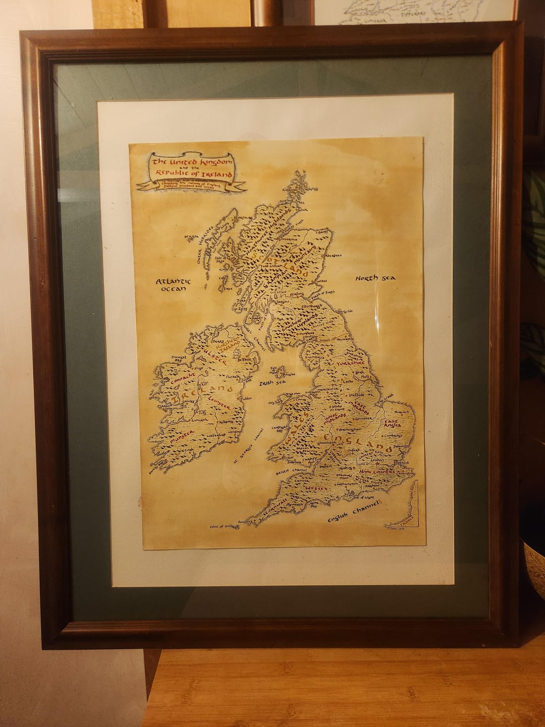
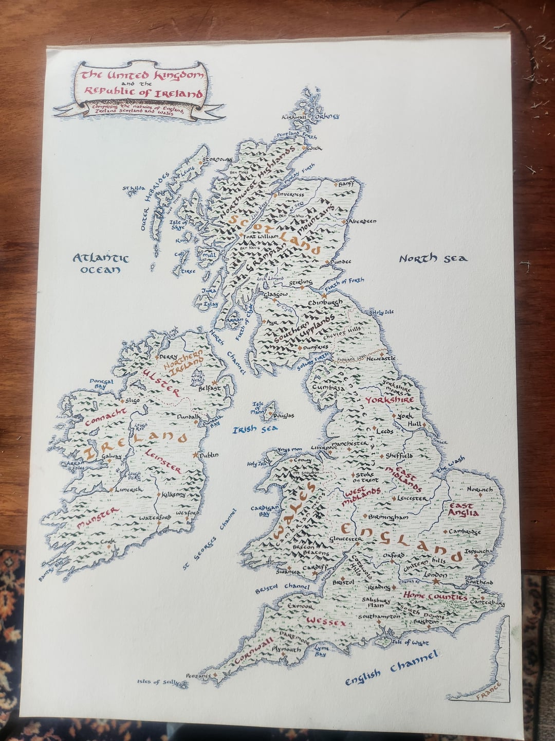
Shame there wasn’t room for Shetland on there, one of our most interesting communities on a linguistic and cultural level.
MathClassCrush on
Sell prints on Etsy and make some pocket money
brianybrian on
Nice map of the Irish Archipelago
Droenra on
looks like someone gave the geography teacher too much free time
ComplexAsk1541 on
You forgot Shetland.
ExampleMediocre6716 on
Very Tolkienesque. Should really have Sarehole annotated.
Sebulbaaaaaa on
Waiting for the inevitable offended Irishman.
EducationChemical488 on
You drew a picture of the “British Isles”.
No, you drew a picture of Britain & Ireland. “British Isles” is a politically charged term thats been deliberately dropped from diplomatic use & geography textbooks. Its a relic of 1800s British propaganda.
The British Isles is the Island of GB & its jear shore Islands.
Ireland is the Island & its near shore islands
redbottlecapbeercan on
France 😂
No-Willingness-4097 on
Is the exe estuary not on the other side of Dartmoor?
Arkan-Rie on
That’s an awesome map that is giving off LOTR vibes!
(Btw, please ignore the negative comments; this is Reddit, you can’t post anything without some deeply sad, lonely people trying to turn it into a political debate.)
nugnug90 on
There are three Celtic nations here. They’re definitely the Celtic isles not the latter.
Britain and Ireland* or literally just the title of the picture, the United Kingdom and Ireland*
Manaze85 on
If Tolkien had written History of the English Speaking Peoples instead of Churchill
Illustrious_Site_466 on
Why did you put Ireland on it?
SharkeyGeorge on
You’ve drawn Kilkenny and Waterford on the same river. Kilkenny is on the Nore while Waterford is on the Suir. They merge and empty into the Irish Sea at Waterford Harbour but Waterford isn’t on the Nore.
You’ve also placed Galway about 25km away from its location which is at the mouth of the River Corrib.
Haggis89 on
Banff? Of all the towns on the NE coast you went with those c*nts?
Disjointbacon on
Since you included part of France, The channel islands would’ve been a cool inclusion but even without it’s still an amazing map 🙂
cupan-tae on
Uh oh..
polabarto on
shetland always gets left out like it’s not literally part of the story
HohepaPuhipuhi on
Gtfoh
Petufo on
Derry ♥️🇮🇪
Terrible_Biscotti_16 on
Ireland isn’t part of the naming convention
JackWelshKazoo on
why is everybody mad😭 this is amazing
Fantastic_Low_1537 on
You know you can just buy one?
1tiredman on
That island on the left is Irish, not British. We are Irish
russians-gonna-rush on
Cool! Do you take orders?
Short-Detective-530 on
👍🏻
jesuslivesnow on
Each time I see these types of maps, the first thing that comes to mind “In the land of Mordor, in the fires of mount doom…”
Plastic-Ad-417 on
There is no such thing as the British Isles. Leave Ireland out of it.
Plastic-Ad-417 on
Please don’t use the expression British Isles much better to use something neutral like I.O.N.A. = Islands Of the North Atlantic (not withstanding Iceland is not part of the area, I know)
Jussme333 on
Fake and gay you didn’t add the glorious shire or Wiltshire or it’s shining capital among the green plains Trowbridge within it. 0/10
trysca on
What were the criteria for including/ excluding towns and cities? Exeter & Truro seem strange omissions for example


38 Comments
Very nice
Nice
Shame there wasn’t room for Shetland on there, one of our most interesting communities on a linguistic and cultural level.
Sell prints on Etsy and make some pocket money
Nice map of the Irish Archipelago
looks like someone gave the geography teacher too much free time
You forgot Shetland.
Very Tolkienesque. Should really have Sarehole annotated.
Waiting for the inevitable offended Irishman.
You drew a picture of the “British Isles”.
No, you drew a picture of Britain & Ireland. “British Isles” is a politically charged term thats been deliberately dropped from diplomatic use & geography textbooks. Its a relic of 1800s British propaganda.
The British Isles is the Island of GB & its jear shore Islands.
Ireland is the Island & its near shore islands
France 😂
Is the exe estuary not on the other side of Dartmoor?
That’s an awesome map that is giving off LOTR vibes!
(Btw, please ignore the negative comments; this is Reddit, you can’t post anything without some deeply sad, lonely people trying to turn it into a political debate.)
There are three Celtic nations here. They’re definitely the Celtic isles not the latter.
Edit : technically four including Cornwall
Still a great drawing
The [Aran islands](https://en.wikipedia.org/wiki/Aran_Islands) in Ireland only has one R in the name, not two.


Britain and Ireland* or literally just the title of the picture, the United Kingdom and Ireland*
If Tolkien had written History of the English Speaking Peoples instead of Churchill
Why did you put Ireland on it?
You’ve drawn Kilkenny and Waterford on the same river. Kilkenny is on the Nore while Waterford is on the Suir. They merge and empty into the Irish Sea at Waterford Harbour but Waterford isn’t on the Nore.
You’ve also placed Galway about 25km away from its location which is at the mouth of the River Corrib.
Banff? Of all the towns on the NE coast you went with those c*nts?
Since you included part of France, The channel islands would’ve been a cool inclusion but even without it’s still an amazing map 🙂
Uh oh..
shetland always gets left out like it’s not literally part of the story
Gtfoh
Derry ♥️🇮🇪
Ireland isn’t part of the naming convention
why is everybody mad😭 this is amazing
You know you can just buy one?
That island on the left is Irish, not British. We are Irish
Cool! Do you take orders?
👍🏻
Each time I see these types of maps, the first thing that comes to mind “In the land of Mordor, in the fires of mount doom…”
There is no such thing as the British Isles. Leave Ireland out of it.
Please don’t use the expression British Isles much better to use something neutral like I.O.N.A. = Islands Of the North Atlantic (not withstanding Iceland is not part of the area, I know)
Fake and gay you didn’t add the glorious shire or Wiltshire or it’s shining capital among the green plains Trowbridge within it. 0/10
What were the criteria for including/ excluding towns and cities? Exeter & Truro seem strange omissions for example