

The UK is set to be warmer than Greece this weekend – despite weather warnings for wind and rain.
Temperatures could peak at 16C on Friday, the Met Office said. It compares to 7C forecast in Athens, with Greece currently experiencing unusually chilly weather.
The above-average temperatures in the UK come as the weather agency issued yellow weather warnings for parts of the country on Friday and Sunday, with the potential for “dangerous conditions” near coasts.
On Friday, parts of Wales, Scotland and Northern Ireland could see winds of up to 70mph, while parts of Scotland could see up to 40mm of rainfall over a six-hour period.
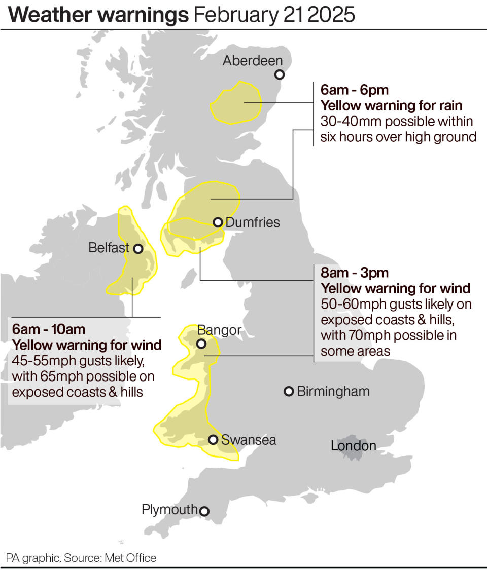
Weather warnings for Friday. (PA)
And on Sunday, many central, northern and western parts of the UK will see gusts of up to 60mph, some of which will be accompanied by heavy rain.
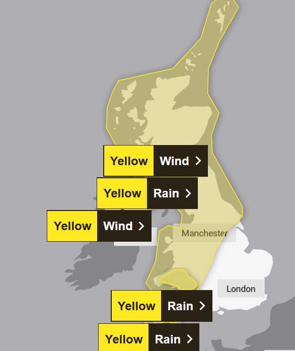
Weather warnings for wind and rain cover much of the country on Sunday. (Met Office)
Still, temperatures will remain mild: at 10C in many of the affected areas. It compares to 8C forecast in Athens.
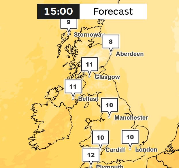
Mild temperatures are forecast on Sunday, despite the Met Office warnings. (Met Office)
Met Office chief meteorologist Steve Willington said: “As we shift from a cold easterly weather regime to milder westerly conditions, the Atlantic air brings with it some potentially impactful weather. Over the coming days, successive weather fronts bring strong winds and bands of rainfall across the UK with a risk some areas, particularly in the west later in the weekend, could see some low or even medium impacts.
“Weather warnings have been issued to highlight the potential for travel disruption, dangerous conditions near coasts and the possibility of power cuts for some.
“Temperatures are also on the rise as part of this change, possibly peaking at 16C in sheltered areas to the east and north of high ground today and on Friday, which is well above average for the time of year.”
Here, Yahoo News UK provides a region by region breakdown, using Met Office forecasts, of the weather over the next few days.
London and the South East
Mostly cloudy with strong winds, early rain clearing and then dry before another band of rain moves east later. Wind slowly easing, perhaps some mist patches towards dawn. Maximum temperature 13C.
Cloudy Saturday, with rain or showers slowly clearing east and afternoon sunny spells. Further rain, and strong winds later Sunday. Monday cloudy, some showers perhaps persistent rain far south. Mild.
South West
Another unsettled day with outbreaks of rain, heavy in places, and coastal gales. Becoming drier into the evening. Temperatures notably above the February average, but not always feeling so. Maximum temperature 14C.
Sunnier spells possible on Saturday and Monday with scattered showers. A wet and windy Sunday in between. Mild over the weekend, then temperatures dropping closer to average next week.
Midlands
East Midlands: Mostly cloudy with strong winds, mostly dry with some patchy rain over Derbyshire hills until evening. Winds slowly easing during the evening, perhaps some mist patches towards dawn. Maximum temperature 14C.
West Midlands: Another unsettled day with outbreaks of rain, heavy in places, and gales over hills. Becoming drier into the evening. Temperatures notably above the February average, but not always feeling so. Maximum temperature 14C.
East Midlands: Cloud slowly breaking Saturday, with sunny spells and scattered showers following. Further rain, and strong winds later Sunday. Monday showers at first, sunny spells. Mild.
West Midlands: Sunnier spells possible on Saturday and Monday with scattered showers. A wet and windy Sunday in between. Mild over the weekend, then temperatures dropping closer to average next week.
North East
Cloudy with strong winds and rain, persistent across some western hills, and drier intervals most frequent in the east. Rain clearing later and winds slowly easing. Clear spells overnight. Maximum temperature 12C.
Mainly dry Saturday, with sunny spells likely developing. Further rain, and strong winds Sunday. Monday, a mix of sunny spells and showers. Mild.
North West
Another unsettled day with outbreaks of rain, heavy in places, plus gales around coasts and hills. Drier into the evening. Temperatures above the February average, but not always feeling so. Maximum temperature 14C.
Sunnier spells possible on Saturday and Monday with scattered showers. A wet and windy Sunday in between. Mild over the weekend, then temperatures dropping closer to average next week.
It may be mild at the moment, but it’s also turning increasingly windy 🌬️
A swathe of gales, locally severe, will affect Irish Sea coasts on Friday
Strong winds are also expected on Sunday, with weather warnings issued for both days ⚠️
Latest info 👉 https://t.co/QwDLMfRBfs pic.twitter.com/ifLHc4JmBG
— Met Office (@metoffice) February 20, 2025
Scotland
Wet and windy with strong to gale force southerly winds. The rain heavy and persistent at times with surface water and spray. Mainly dry with clear spells developing by evening. Maximum temperature 12C.
Mainly dry and bright on Saturday with sunny spells. More wet and windy weather on Sunday, gales or severe gales, then bright with heavy, blustery showers on Monday.
Northern Ireland
Heavy rain with strong to gale force southerly winds, severe at first around the east coast. Drier and brighter conditions then developing in the afternoon with a scattering of showers. Maximum temperature 12C.
Bright with scattered showers on Saturday. More wet and windy weather on Sunday, gales or severe coastal gales, then bright with occasional showers on Monday.
Wales
Another unsettled day with outbreaks of rain, heavy in places, and locally severe coastal gales. Drier into the evening. Temperatures notably above the February average, but not always feeling so. Maximum temperature 13C.
Sunnier spells possible on Saturday and Monday with scattered showers. A wet and windy Sunday in between. Mild over the weekend, then temperatures dropping closer to average next week.