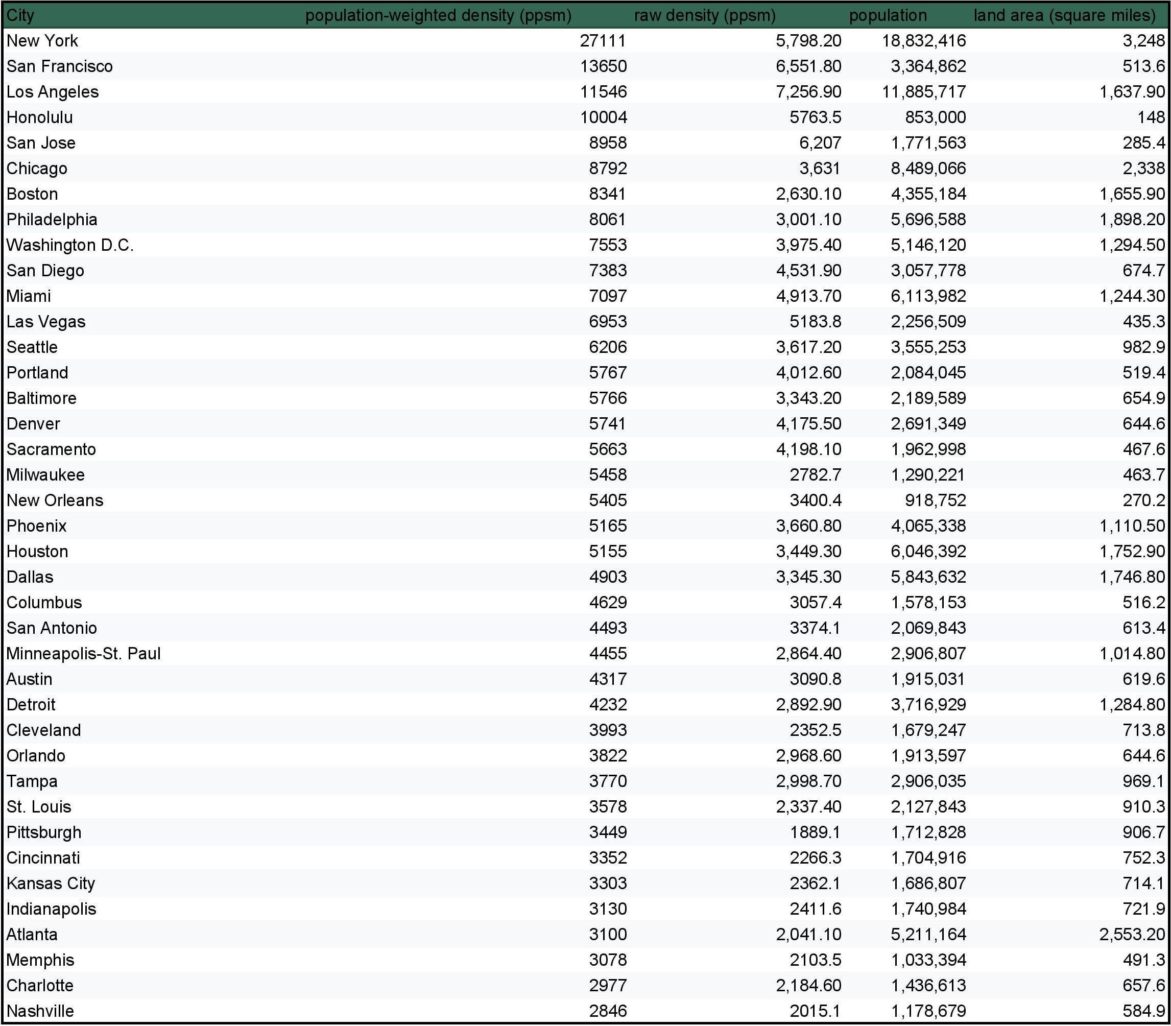
First, some context. What is an urbanized area, you might ask? An urbanized area is essentially a conglomeration of the entire built-up region of a city and its surrounding suburbs. One mistake a lot of people tend to make when comparing cities is solely looking at city limits. However, the problem with this approach is that city limits tend to be fairly arbitrary and inconsistent. They are imaginary lines on a map that don’t look at where people actually live. People have tried to fix this by using another measurement called metro areas, which are typically a conglomeration of counties that are part of the same area. However, this approach has the same issue of arbitrarily drawn lines, except at the county level. For example, Las Vegas’ Clark County includes a lot of empty desert, even though the overwhelming majority of the county’s population live in a relatively small portion of the land in Las Vegas and surrounding communities. To mitigate this, most urban planners use what is called urbanized areas, which only look at the built-up areas of a city and its surrounding areas. That means rural areas and areas that would be separate from the main city and its vicinity would not be included, so the statistics can focus solely on the areas that are actually urbanized, without the numbers being skewed by rural mountains/bodies of water, etc.
With that being said, raw population density alone can be misleading too, because it simply averages out the density in an entire region, without taking into consideration where the vast majority of people live. This is seen in New York City and Los Angeles, where despite LA City being significantly less dense than NYC, the Los Angeles urbanized area is actually denser than New York, and in fact is actually the densest urbanized area in the United States. That is because Los Angeles’ suburbs are about twice as dense as New York’s. With that being said, more people in New York experience higher density than people in Los Angeles. To fix this, population-weighted density was created, which weights population and adjusts calculations based on where the majority of people live.

![[OC] US urbanized areas ranked by population-weighted density](https://www.byteseu.com/wp-content/uploads/2025/03/i5k846htt8ne1-1536x1346.jpeg "[OC] US urbanized areas ranked by population-weighted density")
6 Comments
Yeah Minneapolis and Saint Paul isn’t really an area its two different cities with very different demographics.
A re-upload because I forgot to add Las Vegas (sorry Las Vegans!)
Sources:
[Weighted population densities](https://urbanstats.org/)
[Raw density, population, and land area](https://censusreporter.org/)
I made this chart using Google Sheets.
First, some context. What is an urbanized area, you might ask? An urbanized area is essentially a conglomeration of the entire built-up region of a city and its surrounding suburbs. One mistake a lot of people tend to make when comparing cities is solely looking at city limits. However, the problem with this approach is that city limits tend to be fairly arbitrary and inconsistent. They are imaginary lines on a map that don’t look at where people actually live. People have tried to fix this by using another measurement called metro areas, which are typically a conglomeration of counties that are part of the same area. However, this approach has the same issue of arbitrarily drawn lines, except at the county level. For example, Las Vegas’ Clark County includes a lot of empty desert, even though the overwhelming majority of the county’s population live in a relatively small portion of the land in Las Vegas and surrounding communities. To mitigate this, most urban planners use what is called urbanized areas, which only look at the built-up areas of a city and its surrounding areas. That means rural areas and areas that would be separate from the main city and its vicinity would not be included, so the statistics can focus solely on the areas that are actually urbanized, without the numbers being skewed by rural mountains/bodies of water, etc.
With that being said, raw population density alone can be misleading too, because it simply averages out the density in an entire region, without taking into consideration where the vast majority of people live. This is seen in New York City and Los Angeles, where despite LA City being significantly less dense than NYC, the Los Angeles urbanized area is actually denser than New York, and in fact is actually the densest urbanized area in the United States. That is because Los Angeles’ suburbs are about twice as dense as New York’s. With that being said, more people in New York experience higher density than people in Los Angeles. To fix this, population-weighted density was created, which weights population and adjusts calculations based on where the majority of people live.
[This video by Oh the Urbanity!](https://www.youtube.com/watch?v=85ris-glYLE) goes more into detail on this.
[This video by That Is Interesting](https://www.youtube.com/watch?v=2ObVNYkMPLY) explains the difference between city propers, metro areas, and urbanized areas.
At least it’s not a Sankey.
My dude, that’s not beautiful, that’s a raw data sheet.
How is New York defined here? ‘Cause New York is in no universe twice as large as Los Angeles.
Dark green header with black writings ?