

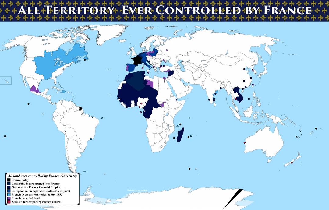
This map was created by Drix (u/RelatedRed) and me. As far as we know, it is the most detailed and complete map of its kind.
This project is the result of months of collaborative research, and none of it would have been possible without Drix joining me in this crazy endeavor.
Thank you so much!
-=-=-=-=-=-=-=-=-=-=-=-=-=-=-=-=-=-=-
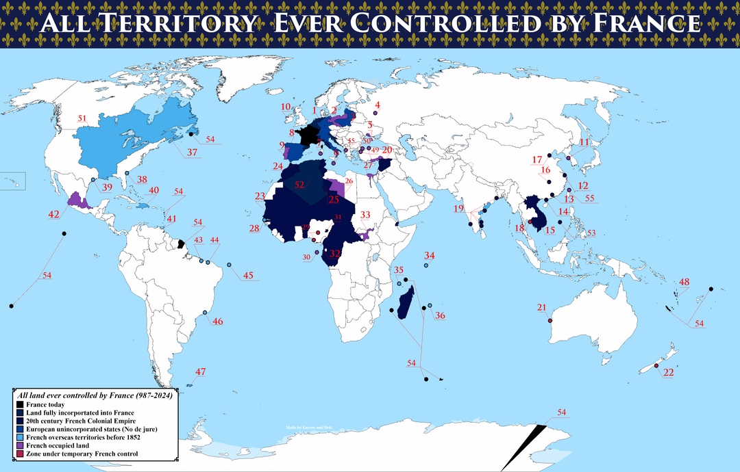
Below is the legend for the second image, explaining what everything reffers to.
2: Occupied Kingdom of Prussia before the Franco-Prussian treaty of Tilsit
3: Duchy of Warsaw and Courland Governorate
4: French occupation of Moscow
5: Southern Russia intervention
7: French expedition to Sardinia
8: Client states of the First Empire or Sister Republics
9: French Invasion of Portugal)
10: French expedition to Ireland
11: French expedition to Korea
12: French Concession of Shanghai
13: French Concession of Shamian Island
14: Leased Territory of Guangzhouwan
16: French concession of Hankou
17: French concession of Tianjin
18: Temporary French occupation of Chantaburi
19: French India
20: Mandate for Syria and the Lebanon
23: French colonial empire in Africa
24: French protectorate in Morocco and the treaty of Madrid of 27 November 1912
25: French concessions to Italian Libya
26: Fezzan-Ghadames Military Territory
27: French campaign in Egypt and Syria
29: Enclaves of Forcados and Badjibo
31: French de facto protectorate in Muri
32: French colony in Equatorial Guinea
33: Fashoda Incident
36: Isle de France)
37: New France
38: French Florida
39: French colonization of Texas
40: French colonies in Hispaniola
42: Second French intervention in Mexico
43: Equinoctial France at Saint-Louis
44: Ibiapaba
47: Îles Malouines
48: New Hebrides
49: French occupation of Anatolia
50: Occupation of Constantinople
51: Louisiana)
52: French Algeria
53: Paracel Islands and Spratley Islands
Posted by Enyrox
20 Comments
what a terrible colour scheme, is it so difficult to use different colours?
Could you redo these with different colours? most of these are very hard to distinguish.
it looks like you missed the French invasion of England where some of Britain was occupied in 1215-1217
[https://en.wikipedia.org/wiki/First_Barons%27_War](https://en.wikipedia.org/wiki/First_Barons%27_War)
Well done on including Clipperton Island. It’s uninhabited, so it’s often left off of these maps, but it is still straight up french territory.
How colorblind people see:
Why using such a royalist design? Most of those territories were controlled longer under the Empire (Napoleon) or the Republic.
It’s missing Indonesia and some islands in Asia/Oceania and the Atlantic.
Good job nonetheless.
For having made the exact same map for clients, I know that it required a lot of documentation.
Napoleon selling USA/Canada lands for making war to Russia is probably the worst deal in history
*claimed to be controlled
I never knew that France had a colony in New Zealand. We’re only told about British Colonisation here
Your title is a bit misleading. I clicked on some of your links because I never knew France controlled territories there, but the articles indicated they tried and lost the battles only to get chased out 😂
French Western Australia legally covered all of Western Australia and, likewise, the Second Mexican Empire legally claimed all of Mexico, if you’re going to include the French Antarctic claim then why not include these claims? Also, why didn’t you include the French Spheres of Influence in Siam and China?
Points for including Akaroa New Zealand.
Saying France controlled much of what was sold in Louisiana purchase is perhaps overselling reality. Claimed would be more precise.
The good old days
They surrendered most of those territories
England?
Yes I love the dark blue, lighter dark blue and kinda dark blue color scheme. Good choice.
It’s fascinating that despite having very little presence in Brazil, France motivated the building of two important Brazilian cities to keep them out, Rio de Janeiro and São Luís
Do not redo it with completely different colors. Use shades and patterns. That is a design recommendation. 4.5% of the world population is color blind. They would not be able to read the maps with completely different colors. You can also just look up color palettes online. What you have there doesn’t have enough contrast at the moment.