
![[OC]Mapping America’s Most Desolate Areas by Distance from Costco and Sam’s Club](https://www.byteseu.com/wp-content/uploads/2025/07/ux4o03wkmdaf1-1536x681.png "[OC]Mapping America’s Most Desolate Areas by Distance from Costco and Sam’s Club")
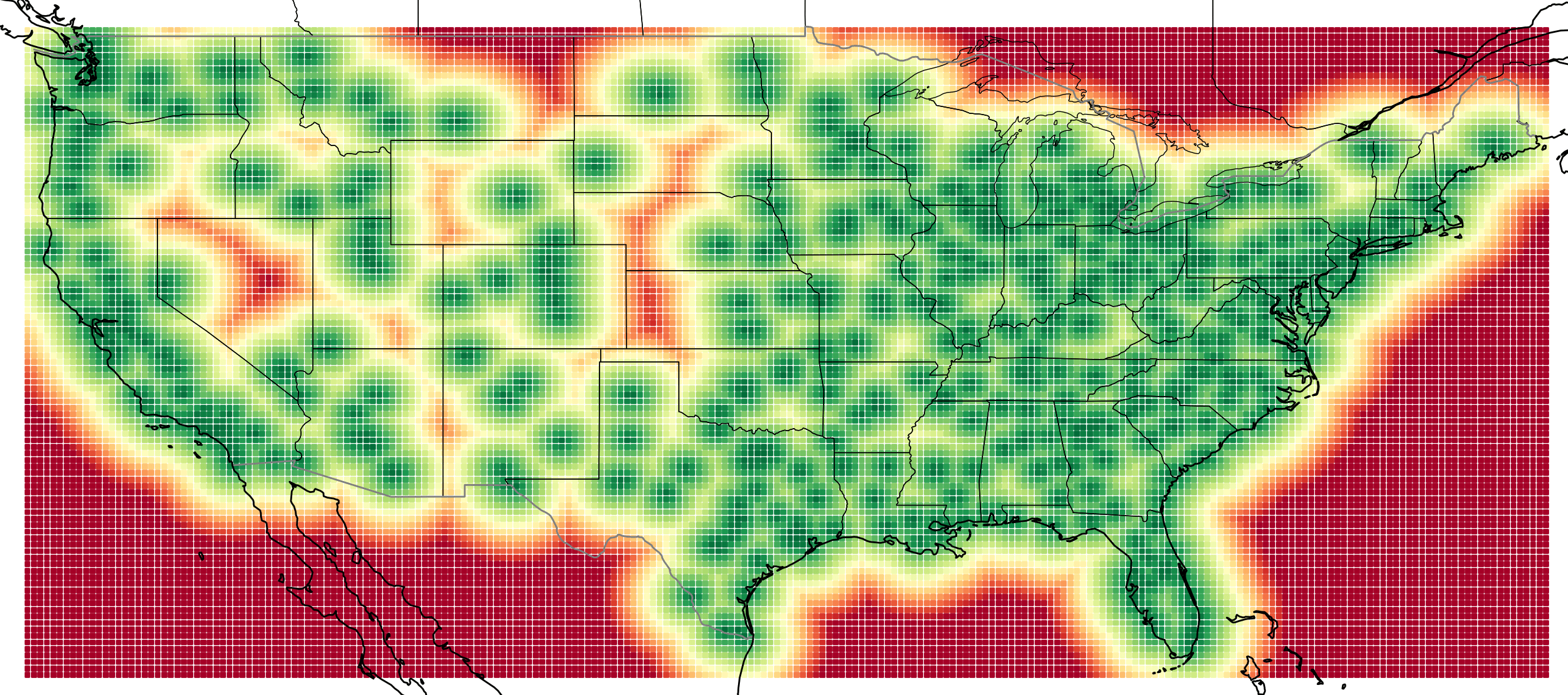
I created a heatmap showing how far every point in the continental US is from the nearest Costco or Sam’s Club location. Instead of population density, this measures geographic desolation based on access to these wholesale stores. The color scale runs from 0 to 220 miles, with red areas representing the most isolated regions and green areas indicating close proximity.
Data sources: Costco locations from Kaggle, Sam’s Club geocoded via OpenStreetMap. Visualization built with Python, Cartopy, and Matplotlib.
Posted by JiveTurkey90
25 Comments
That SLC Costco is the biggest I’ve ever been to. It was like 2.5x the size of a normal Costco.
I bought my first Costco membership a month ago, the Costco is 2 miles away, I’ve still never been -_-
Odd how there’s that little region in the middle that doesn’t have a Costco near it
Is Havre MT the largest city in the red zones?
[deleted]
Can you do this for the whole of North America? And just a Walmart one? I think I’ve heard 90% of Americans live 10 miles away from a Walmart
It’s hard explaining to people how unpopulated and isolated the area I grew up in is. I used to say you have to drive an hour just to get to a Walmart. But I think I found a better way to show it. I made this map that measures how far you are from the nearest Costco or Sam’s Club. I grew in the red, but to my surprise, not the deep red.
AMA From the Red
Cool, you should include Alaska and Hawaii
I’m not sure this is accurate. This seems to show a Costco on the panhandle near Panama City where there isn’t one.
Here are the Costco’s https://imgur.com/a/oKRuqNO
Oh or Sam’s club. Doh
Could you do one with just Costco?
/u/JiveTurkey90
I used to live in a red area. Watertown South Dakota.
Red as in conservative or red on this map? Yes.
And yet it’s just another population density map.
The map is incorrect for upstate NY – it’s missing Sam’s Clubs in Elmira, Binghamton, Albany, and Watertown
I take it you aren’t considering the Costco in Regina?
God I hate that protection for the US. Also a super easy map to make, and make look a lot better.
It’s interesting being able to visualize the sphere of influence around my local Sam’s Club
You can see the drive I made!
Weeks back I left Chardon, NE and drove to Omaha. I passed 0 Walmarts over about 400 miles. 1st one was in Freemont, NE.
It was a stark reminder that a few folks live a very different life than most.
Hell from Rapid City, SD to Omaha I passed only the one in Chardon. That’s 500 miles.
I aint no CEO but what I see is a bunch of oceanic business opportunities.
The fun yellow void in upstate NY is Albany. I lived there. It sucked because there was no Costco.
Since I’m not in the US I don’t know how much driving distance each point on the grid is.
Using Wyoming as an example, it looks like there are 2 Costcos or Sam Clubs (or 2 combinations of Costco+Sam Club), one at approximately Casper and one at approximately Cheyenne.
Using the Casper (ish) location occupying about 1/3 of Wyoming horizonally… are there really people driving 200+ miles to get to a Costco?
Nevada doesn’t get glizzy with it
You should add BJ’s to this list
I wonder if the map for Starbucks will be the same
I used to live 5 minutes from Costco. Now I live 45 minutes. It’s hell.
Couldn’t imagine being in the red death zones.
Equating Costco and Sam’s Club is criminal. Fuck Walmart.
You dumbass. This should/ve been sold to PE to buy up viable land ^/s