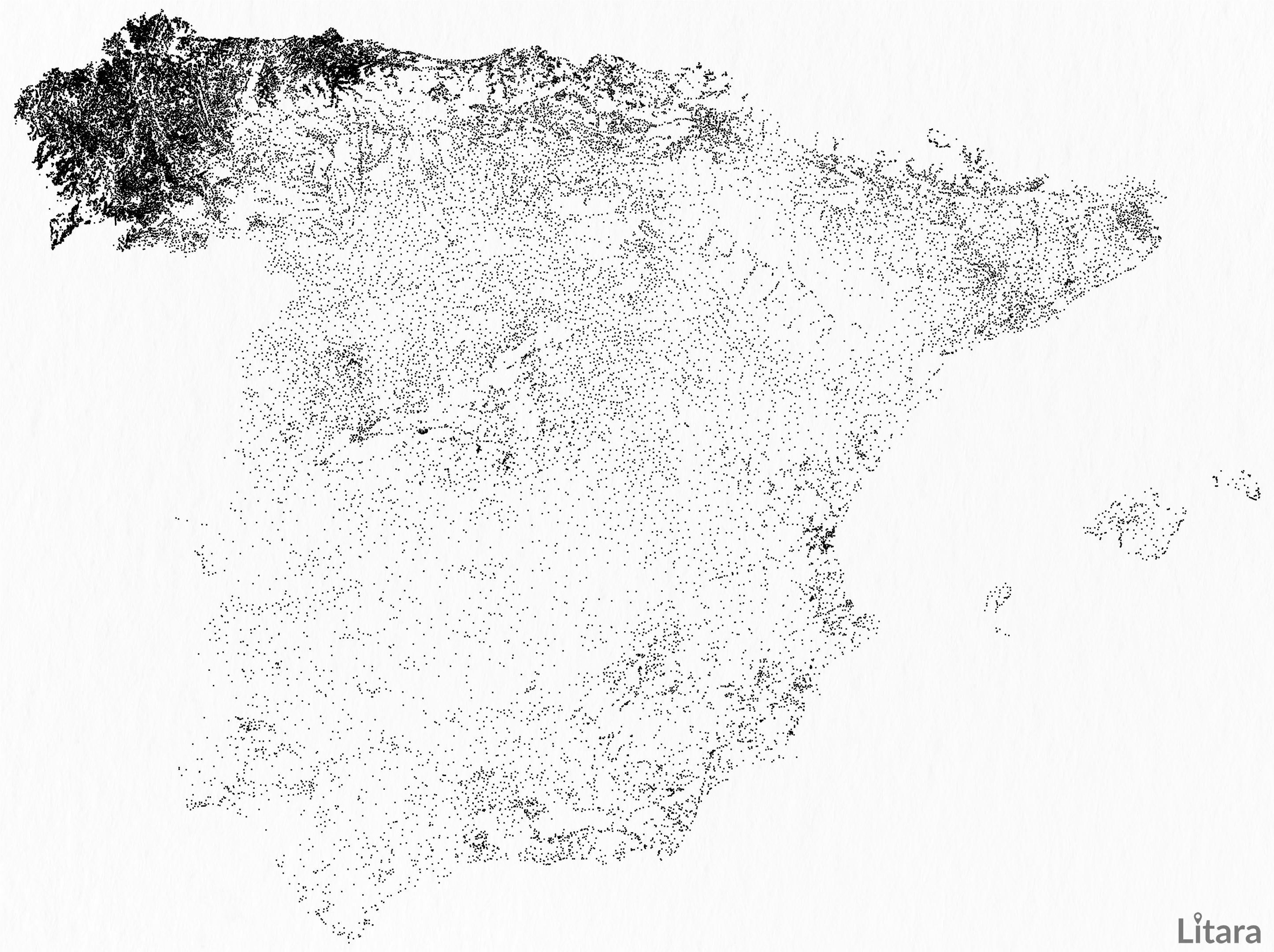
[OC] I visualized 52,323 populated places in European part of Spain and accidentally uncovered a stunning demographic phenomenon.
Posted by paveloush

![[OC] I visualized 52,323 populated places in European part of Spain and accidentally uncovered a stunning demographic phenomenon.](https://www.byteseu.com/wp-content/uploads/2025/08/s1b1v8lmq0lf1-1536x1148.jpeg "[OC] I visualized 52,323 populated places in European part of Spain and accidentally uncovered a stunning demographic phenomenon.")
[OC] I visualized 52,323 populated places in European part of Spain and accidentally uncovered a stunning demographic phenomenon.
Posted by paveloush
31 Comments
As a personal project, I’m creating artistic maps from geographic data. For this “Stardust” version of Spain, I plotted every single populated place from OpenStreetMap for the mainland and the Balearic Islands.
I initially thought the bright cluster in the northwest was a bug in my code. But after some research, I was amazed to find it’s a real, well-documented phenomenon known as “dispersed settlement,” unique to Galicia (where almost half of all of Spain’s populated entities are located).
What about those letters in the upper right side:
PTRIA?
Does this also apply in Portugal?
Very interesting. Asturias and cantabria are also remarkable
The Donegal of Spain…
Fascinating.
I love it, I’m actually from Galicia.
Due to agriculture and difficult terrain each “town” is composed of several hamlets or communities.
It also extends to Asturias and north of Portugal.
Galicia has rainy weather and a better environment for farms. The rural countryside is better able to sustain a population. It also has easy access to the sea
Is there a non European part of Spain?
Isn’t Spain more or less a union of previously independent states and doesn’t this map just show the remains of that period where every state had their own laws about what counted as a settlement and what doesn’t?
I’m a bit confused, seems like there’s areas in the middle of Madrid that are blank on this map? Did you just mark Madrid as one dot? If so, I understand that each settlement equals one dot, but the existence of a major city like Madrid is obviously going to prevent any other settlements from propping up within it’s preexisting boundaries, so it seems a little misleading to not acknowledge that some of those blank bits are in fact urban areas, as if the political entity that is Madrid didn’t exist, each neighbourhood could well have been considered it’s own settlement.
If I misunderstood then I take it back, cool map either way.
i don’t get what anything in this picture means, is each dot a unique ‘populated place’? are the darker regions suggesting a higher population?
There is definitely some difference with settlement pattern in Galicia being closer to Portugal than the rest of Spain but your OSM data is also off. I mean you can barely see Madrid, Barcelona, Valencia or any major cities outside of Galicia for that matter.
[Here is a map of inhabited areas in Spain I made sometime with Eurostat data](https://www.reddit.com/user/ZigZag2080/comments/1jkiuq9/spain_inhabited_areas/).
You always have to be careful with OSM-data because some areas are bound to be mapped in way more detail than others.
This might be a quirk of the website you were you using. Not every single Spanish town is included.
In galicia we call it dispersion poblacional. If you travel by road you will constantly see little groups of houses, not even a hamlet by the road.
I wonder if there are any historical reasons why there are so many separate/unique points for data collection for these hamlets. Less of a demographic phenomenon unless this is also representing population density, and more of an administrative phenomenon.
Define “populated place”. Is this to say there are lots and lots of officially recognized municipalities in Galicia, and fewer elsewhere? If so, that says nothing particularly profound. For comparison, my county has 19 incorporated municipalities, while Brooklyn county, NY has over 30 times the population but not even one complete city.
That’s it. I want to bikepack there!
It would be very interesting to check whether the Galician pattern continues southward to Portugal. Historically, the two regions have a lot in common (even the language was originally the same).
You uncovered they decided to spell something resembling PTEA on that Northeast area? 🤣
Joking aside, the weather on the North end is way much more comfortable.
European part of Spain? Which part of Spain isn’t in Europe?
If you would have done the entire peninsular you would have probably seen a similar pattern along the Portuguese coast That geographic area is just super nice. Feels like spring all year round. Also great Food and great people.
Spain and it’s people is a jewel, a real treasure. I just want to point it out.
Northern Portugal is similar, which isnt that surprising. More surprising perhaps is that Ireland is too
Top-notch content for this sub. Thanks for posting!
Western China is a lot like that. The mountains are functionally impassable, so you have little communities separated by only a few miles but with 5k meter ridges or fast-flowing mountain rivers between them.
Fast forward a few thousand years to today and theyre completely distinct from each other, not just politically but culturally and linguistically, too.
I have heard that we have around half the “places with a name” of the whole country.
So what’s this data showing then?
What is the stunning demographic phenomenon?
Please do the whole Peninsula! Would love to see Portugal too 🙂
Is there some reason why the dots seem to form the word (?) PTEM
Demographic? You mean geographic?