
![[OC] Distribution of Prehistoric Forts in Ireland](https://www.byteseu.com/wp-content/uploads/2025/09/p50zzc84a2qf1-1024x724.jpeg "[OC] Distribution of Prehistoric Forts in Ireland")
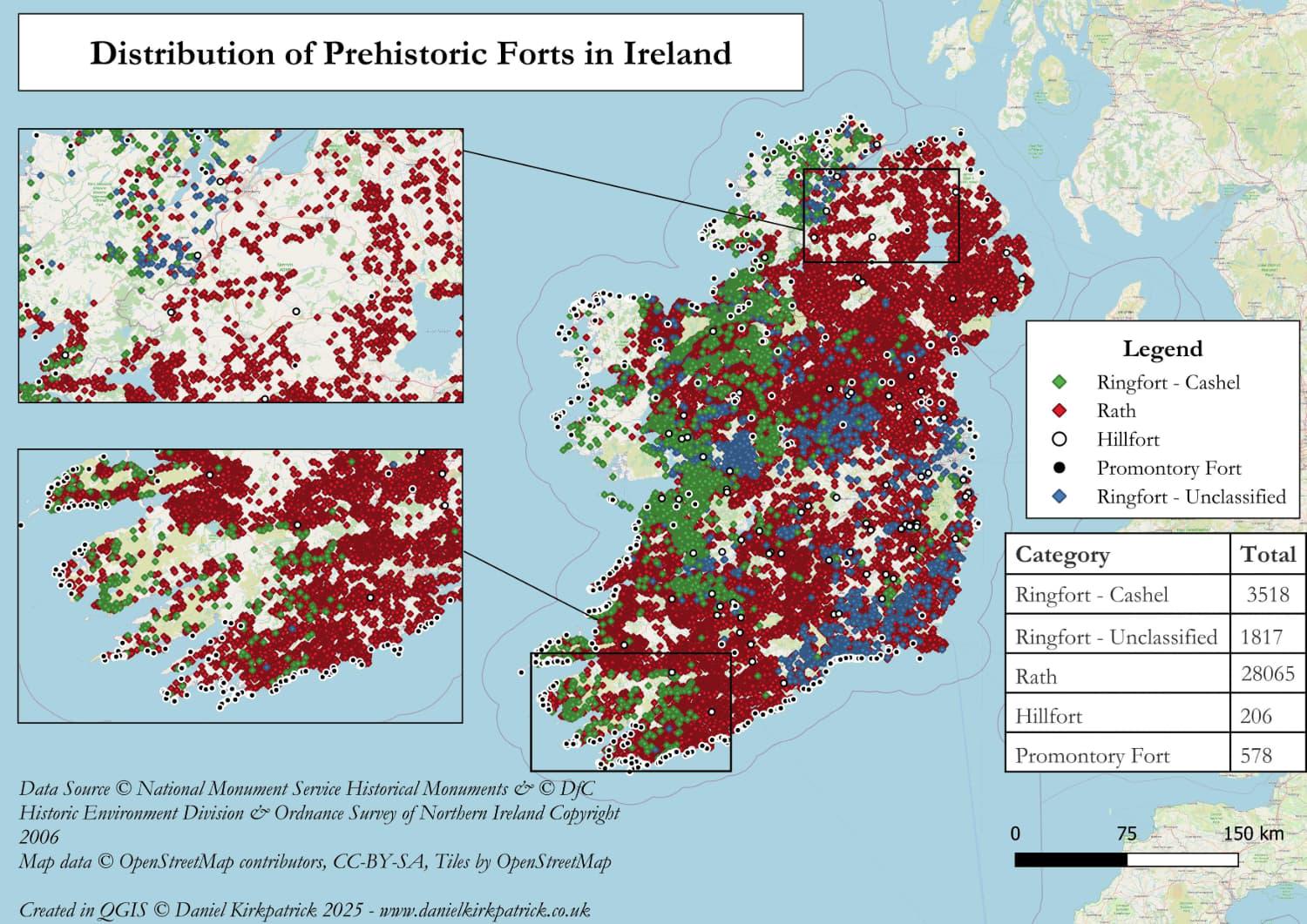
Here are all recorded prehistoric fort locations across Ireland.
The map is populated with a combination of National Monument Service data (Republic of Ireland) and Department for Communities data for Northern Ireland. The map was built using some PowerQuery transformations and then designed in QGIS. Note the data isn't an exact match between the datasets as Northern Ireland doesn't have all the categories provided for the Republic.
I previously mapped hillforts using the Atlas of Hillforts data. Several commented about gaps. This was largely due to the way the data is categorised, with Raths and Ringforts far surpassing hillforts.
Any thoughts about the map or insights would be very welcome
Posted by Sarquin
9 Comments
For those who want to see the data sources check out NMS here [https://www.archaeology.ie/collections-and-publications/publications/monument-class-and-scope-notes/](https://www.archaeology.ie/collections-and-publications/publications/monument-class-and-scope-notes/) and the UK Open Data here [https://www.data.gov.uk/dataset/46240fa5-db15-469e-b1c8-0460504b951c/northern-ireland-sites-and-monuments-record](https://www.data.gov.uk/dataset/46240fa5-db15-469e-b1c8-0460504b951c/northern-ireland-sites-and-monuments-record) For the tooling, I used QGIS and PowerQuery (Excel).
If interested in more background, I have summarised my research on Irish hillforts here: [https://www.danielkirkpatrick.co.uk/historical-sites/irish-hillforts/](https://www.danielkirkpatrick.co.uk/historical-sites/irish-hillforts/)
That’s amazing. I had no idea there were so many. Were they essentially to life back then? (no pun intended)
The prehistoric irish REALLY didn’t like eachother!
Fantastic OP! I’m fascinated by them. Is there a map available for us to use in real-time? Zoom in etc…
If not, what program/site can I use to import the json?
I wonder why there appear to be relatively few (low density) in West (Connacht/Mayo+Galway) Ireland. What’s up with that?
It says Fort not *fork*, brain…
https://preview.redd.it/bobigyirg3qf1.jpeg?width=3072&format=pjpg&auto=webp&s=e37be9eba251d318eb9d7d362a160a9b36f534bd
On the bank of one in Cavan. Overlooks a river and lots on both sides. River was a boundary for two different tribes in the past.
https://preview.redd.it/xz7ajeh0h3qf1.jpeg?width=4096&format=pjpg&auto=webp&s=8e2d0dd68797252dc36cb28eae5553a1cfd19c0e
Inside the ringfort
https://preview.redd.it/p3cr6mj4h3qf1.jpeg?width=4096&format=pjpg&auto=webp&s=bb788c115c4c18faa359dd96cae7dceea1835893
Outside view.