
![[OC] Map of Historical Sites Across North Antrim, Northern Ireland](https://www.byteseu.com/wp-content/uploads/2025/11/8peayqx0gnyf1-1024x712.jpeg "[OC] Map of Historical Sites Across North Antrim, Northern Ireland")
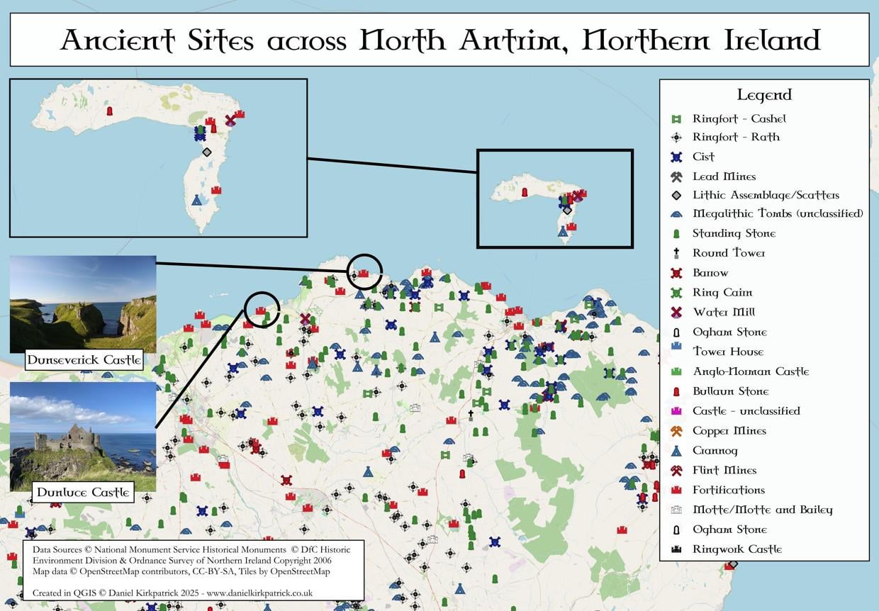
This is a map showing the locations of recorded historic locations across the North Antrim coastline in Northern Ireland. I've tried to focus on the main categories as otherwise it would become an even longer legend than it already is. Hopefully this is helpful for anyone visiting the area or researching it.
For those wondering why I chose my photographs to focus on Dunluce and Dunseverick castles, for me they are two of the most interesting for very different reasons: Dunluce because it just looks awesome (granted it also has an interesting medieval history), Dunseverick because it's one of the oldest and most historically significant locations in the region (having once been a royal site possibly dating back to the Bronze Age).
The locations are based on the Department for Communities data for Northern Ireland. The map was built using some PowerQuery transformations and then designed in QGIS.
I previously mapped a bunch of other ancient monument types, the latest being Bullaun stones across Ireland.
Any thoughts about the map or insights would be very welcome. I'm looking to create a few more like this focusing on specific regions of across Ireland, so also welcome suggestions on other areas to cover.
Posted by Sarquin
2 Comments
For those who want to see the data source check out the [UK Open Data here](https://www.data.gov.uk/dataset/46240fa5-db15-469e-b1c8-0460504b951c/northern-ireland-sites-and-monuments-record). For the tooling, I used QGIS and PowerQuery (Excel).
If interested, here are the links to my research on Dunluce castle – [https://www.danielkirkpatrick.co.uk/historical-sites/the-history-of-dunluce-castle/](https://www.danielkirkpatrick.co.uk/historical-sites/the-history-of-dunluce-castle/) – and Dunseverick Castle – [https://www.danielkirkpatrick.co.uk/historical-sites/the-history-of-dunseverick-castle/](https://www.danielkirkpatrick.co.uk/historical-sites/the-history-of-dunseverick-castle/)
Well done!
I’d love to see some of this data juxtaposed with potential threats to maintaining heritage sites, like planned development. It always kind of blew my mind that in NI you’ll see old castle fortifications totally unused in the middle of a small town. In other countries (especially ones with a history of sectarian violence) pre-Christian/pre-Islamic historic sites are often destroyed, either intentionally, or accidentally during the construction of housing. I think it’d be interesting to compare where some of these sites, like burial mounds, are in comparison to how the region is zoned and where major land-use changes can be expected.
It’d also be interesting to see where 20th and 21st century religious sites are located vs. ancient ones.