I’m in the middle of it, and I can confirm it’s wet here
_night_hawk19 on
Nothing but blue skies and sunshine in the SE
totowewentcarracing on
Even the weather hates the poors
Prestigious_Fan_1061 on
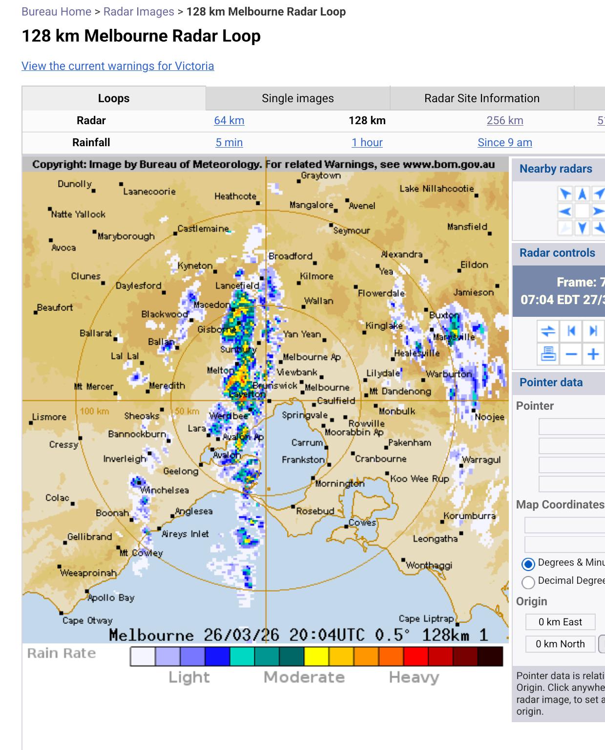
Wind is blowing Northerly from the South. Rain is largely missing Melbourne to the West. It’s unusual but it does happen…
Hot_Cicada_9318 on
Straight off Antarctica. It was a wild night, last night on the Peninsula
BronL-1912 on
Last night? It probably ran out of black ink
tnczvr on
Was it ever not broken?
Ryzi03 on
It’s called ‘[training](https://en.wikipedia.org/wiki/Training_(meteorology))’ in meteorological terms, as in trains along the tracks, and occurs due to an area of stationary instability causing showers to form parallel to the wind over the same area again and again.
It’s hard to tell what the exact source of stationary instability is in this case, possibly something to do with the edge of the upper level low pressure trough passing over us or just from the air being funnelled through the Heads, but the satellite imagery from this morning shows a clear line between the showery clouds to the west of the CBD vs the clearer skies to the east of the CBD.
I’m in Altona North and it’s been pissing down all day
Opening-Listen7833 on
I saw this too, and I was also wondering about it too.
I’ve seen this phenomenon before, but this is quite an extreme version of it
dildoeye on
BOM radar is always broken. I use the ‘Windy’ app now
archieb3000 on
I noticed that when I zoomed out to the national radar that the small line of rain to the west seemed to form over King Island and the central strip of storms started over the North West tip of Tassie. Made me wonder if the topography upwind was a factor.
CoolJRT on
How’d you access the old version? I can’t stand the new site that looks like a blank webpage
harbingerfas on
Most unreliable weather app in the world. You got a window? – open it.
Spectre092 on
Millions spent on the website just to be broken lol
MaximillianRebo on

here_for_the_lols on
It’s not that uncommon for weather features to cause something like this
gccmelb on
I was under it and felt targeted by the weather today.


18 Comments
I’m in the middle of it, and I can confirm it’s wet here
Nothing but blue skies and sunshine in the SE
Even the weather hates the poors
Wind is blowing Northerly from the South. Rain is largely missing Melbourne to the West. It’s unusual but it does happen…
Straight off Antarctica. It was a wild night, last night on the Peninsula
Last night? It probably ran out of black ink
Was it ever not broken?
It’s called ‘[training](https://en.wikipedia.org/wiki/Training_(meteorology))’ in meteorological terms, as in trains along the tracks, and occurs due to an area of stationary instability causing showers to form parallel to the wind over the same area again and again.
It’s hard to tell what the exact source of stationary instability is in this case, possibly something to do with the edge of the upper level low pressure trough passing over us or just from the air being funnelled through the Heads, but the satellite imagery from this morning shows a clear line between the showery clouds to the west of the CBD vs the clearer skies to the east of the CBD.
https://preview.redd.it/27ucl93a1irg1.png?width=1446&format=png&auto=webp&s=ab97461f325fd1340f3caea2ccc7347cfc59df14
I’m in Altona North and it’s been pissing down all day
I saw this too, and I was also wondering about it too.
I’ve seen this phenomenon before, but this is quite an extreme version of it
BOM radar is always broken. I use the ‘Windy’ app now
I noticed that when I zoomed out to the national radar that the small line of rain to the west seemed to form over King Island and the central strip of storms started over the North West tip of Tassie. Made me wonder if the topography upwind was a factor.
How’d you access the old version? I can’t stand the new site that looks like a blank webpage
Most unreliable weather app in the world. You got a window? – open it.
Millions spent on the website just to be broken lol

It’s not that uncommon for weather features to cause something like this
I was under it and felt targeted by the weather today.