Is there a version with the state boundaries overlaid? I’m curious how my expectations based on looking at the terrain would align with reality.
JohnDisinformation on
Does that look like a TACO to you in the first image
olive12108 on
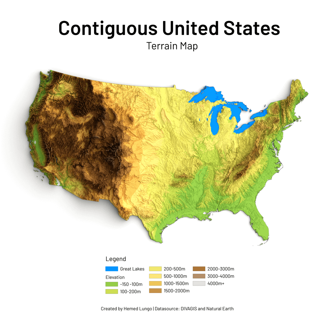
It’s quite crazy Just how much the Hudson and Connecticut Rivers cut through the Northern Appalachian mountains.
Wallace521 on
I love the irony of using metric for a map of the US.
Great map!
lc_barcode on
Why is Lake Tahoe not visible on this map? I’d argue that the elevation change from the Sierras into the Tahoe Basin should be a visible elevation difference.
xxYINKxx on
It looks like every avocado I get from Aldi after a day
xxearvinxx on
Why is Sacramento, CA just whited out on the map?
the_ballmer_peak on
Something weird going on in southeast California. I think that lake is supposed to be the Salton Sea, but the Salton Sea is nowhere near that large. It used to be bigger, but I’m not sure it was ever that big, and it was a long time ago.
It has a very interesting history, from being an accidentally man made lake, to a tourist resort destination, to a toxic puddle. All the while being surrounded by farmland.
jdavid on
I think California built a better wall than the east coast.
babygotthefever on
Would be cool if the spots below sea level were differentiated but otherwise a very interesting way of looking at the country.
No_Freedom_4098 on
Apparently that is the Snake River Plain that is creating that distinct U-shape in the Rocky Mountains. South there appears to be another smaller basin around the Great Salt Lake.
Big_Knife_SK on
You’ve included a lot of Canadian territory this map.
IamSunka on
Wow tornado alley is flat. No mountains.
BernieTheDachshund on
Nice except for the use of meters instead of feet.
Gargomon251 on
Left it in the oven too long
_Cat_12345 on
Oh god first Americans claimed the Gulf of Mexico, now they’re claiming Manitoulin Island.

![[OC] Map showing Contiguous United States Terrain Map](https://www.byteseu.com/wp-content/uploads/2026/04/740p53cdjsug1-1024x965.png "[OC] Map showing Contiguous United States Terrain Map")
20 Comments
Tools: QGIS and Blender
Datasource: DIVAGIS and Natural Earth
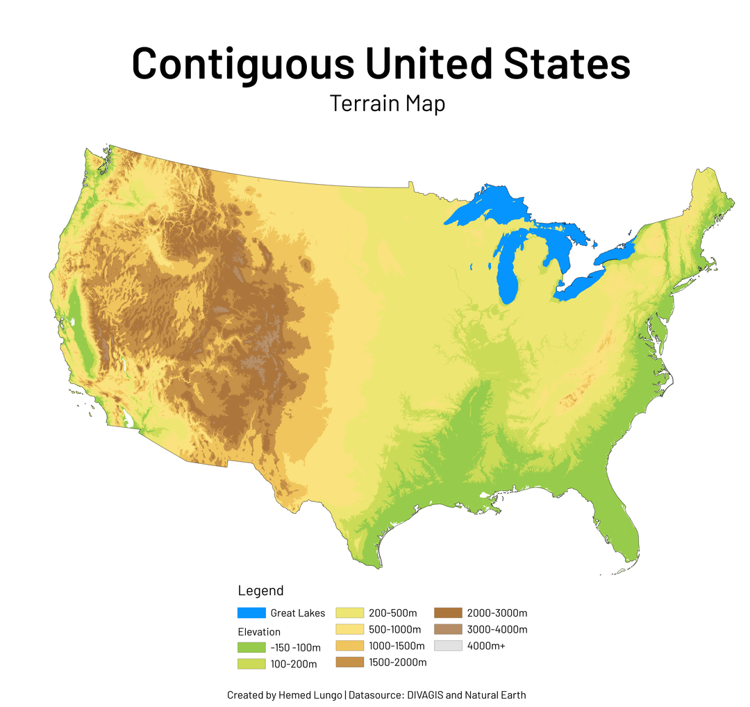
Yay a no shadow version this time 🥰
The blue indicating Great Lakes is very helpful.
Is there a version with the state boundaries overlaid? I’m curious how my expectations based on looking at the terrain would align with reality.
Does that look like a TACO to you in the first image
It’s quite crazy Just how much the Hudson and Connecticut Rivers cut through the Northern Appalachian mountains.
I love the irony of using metric for a map of the US.
Great map!
Why is Lake Tahoe not visible on this map? I’d argue that the elevation change from the Sierras into the Tahoe Basin should be a visible elevation difference.
It looks like every avocado I get from Aldi after a day
Why is Sacramento, CA just whited out on the map?
Something weird going on in southeast California. I think that lake is supposed to be the Salton Sea, but the Salton Sea is nowhere near that large. It used to be bigger, but I’m not sure it was ever that big, and it was a long time ago.
It has a very interesting history, from being an accidentally man made lake, to a tourist resort destination, to a toxic puddle. All the while being surrounded by farmland.
I think California built a better wall than the east coast.
Would be cool if the spots below sea level were differentiated but otherwise a very interesting way of looking at the country.
Apparently that is the Snake River Plain that is creating that distinct U-shape in the Rocky Mountains. South there appears to be another smaller basin around the Great Salt Lake.
You’ve included a lot of Canadian territory this map.
Wow tornado alley is flat. No mountains.
Nice except for the use of meters instead of feet.
Left it in the oven too long
Oh god first Americans claimed the Gulf of Mexico, now they’re claiming Manitoulin Island.
The green area doesn’t have long.